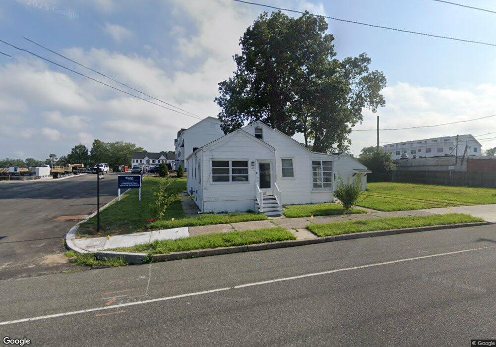
49 Mays Landing Rd Somers Point, NJ 08244
Estimated Value: $223,000 - $332,000
2
Beds
1
Bath
856
Sq Ft
$342/Sq Ft
Est. Value
About This Home
This home is located at 49 Mays Landing Rd, Somers Point, NJ 08244 and is currently estimated at $292,871, approximately $342 per square foot. 49 Mays Landing Rd is a home located in Atlantic County with nearby schools including Mainland Regional High School.
Ownership History
Date
Name
Owned For
Owner Type
Purchase Details
Closed on
Mar 5, 2003
Sold by
Estate Of Norine Snyder
Bought by
Karpf Richard
Current Estimated Value
Home Financials for this Owner
Home Financials are based on the most recent Mortgage that was taken out on this home.
Original Mortgage
$80,000
Interest Rate
5.86%
Create a Home Valuation Report for This Property
The Home Valuation Report is an in-depth analysis detailing your home's value as well as a comparison with similar homes in the area
Home Values in the Area
Average Home Value in this Area
Purchase History
| Date | Buyer | Sale Price | Title Company |
|---|---|---|---|
| Karpf Richard | $110,500 | -- | |
| Karpf Richard A | $110,500 | Congress Title Division |
Source: Public Records
Mortgage History
| Date | Status | Borrower | Loan Amount |
|---|---|---|---|
| Previous Owner | Karpf Richard | $80,000 |
Source: Public Records
Tax History Compared to Growth
Tax History
| Year | Tax Paid | Tax Assessment Tax Assessment Total Assessment is a certain percentage of the fair market value that is determined by local assessors to be the total taxable value of land and additions on the property. | Land | Improvement |
|---|---|---|---|---|
| 2025 | $5,607 | $156,800 | $58,600 | $98,200 |
| 2024 | $5,607 | $156,800 | $58,600 | $98,200 |
| 2023 | $5,239 | $156,800 | $58,600 | $98,200 |
| 2022 | $5,239 | $156,800 | $58,600 | $98,200 |
| 2021 | $5,160 | $156,800 | $58,600 | $98,200 |
| 2020 | $5,055 | $156,800 | $58,600 | $98,200 |
| 2019 | $4,913 | $156,800 | $58,600 | $98,200 |
| 2018 | $4,809 | $156,800 | $58,600 | $98,200 |
| 2017 | $4,637 | $156,800 | $58,600 | $98,200 |
| 2016 | $4,426 | $156,800 | $58,600 | $98,200 |
| 2015 | $4,381 | $156,800 | $58,600 | $98,200 |
| 2014 | $4,787 | $177,300 | $79,100 | $98,200 |
Source: Public Records
Map
Nearby Homes
- Aria Plan at Greate Bay - The Links
- Cadence Plan at Greate Bay - The Links
- Bethany Plan at Greate Bay - The Links
- Strauss with Rooftop Deck Plan at Greate Bay - The Links
- 22 Mays Landing Rd
- 3 Fresh Spring Cove
- 13 Gulph Mill Rd
- 14 Merion Dr
- 19 Holly Hills Dr
- 18 Colwick Dr
- 100 Colwick Dr
- 122 S Pointe Unit 122
- 36 Lehigh Dr
- 120 Jordan Rd
- 7 Shell Lane - Somerset Cove Marina
- 136 Bala Dr
- 173 Bala Dr
- 18 Greate Bay Dr
- 1810 Somers Point Rd
- 500 W New Jersey Ave
- 43 Mays Landing Rd Unit BLDG 6
- 43 Mays Landing Rd
- 43 Mays Landing Rd Unit STORE 5
- 43 Mays Landing Rd Unit 6
- 80 Mays Landing Rd
- 76 Mays Landing Rd
- 74 Mays Landing Rd
- 91 Mays Landing Rd
- 90 Mays Landing Rd
- 31 Mays Landing Rd
- 27 Mays Landing Rd
- 7 Horter Ave
- 92 Mays Landing Rd
- 101 Harlan Ave
- 14 Seashore Ln Unit 16
- 18 Seashore Ln Unit 20
- 26 Mays Landing Rd
- 13 Horter Ave
- 11 Horter Ave
- 3 Horter Ave