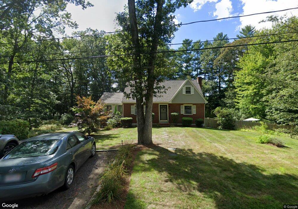
49 Phillips St Hanover, MA 02339
Estimated Value: $658,000 - $828,000
3
Beds
3
Baths
1,799
Sq Ft
$417/Sq Ft
Est. Value
About This Home
This home is located at 49 Phillips St, Hanover, MA 02339 and is currently estimated at $749,870, approximately $416 per square foot. 49 Phillips St is a home located in Plymouth County with nearby schools including Hanover High School, South Shore Charter Public School, and Norwell KinderCare.
Ownership History
Date
Name
Owned For
Owner Type
Purchase Details
Closed on
Jan 14, 2000
Sold by
Krall Thomas F and Krall Carol A
Bought by
Cahalane J Neil J and Cahalane Maryethel E
Current Estimated Value
Purchase Details
Closed on
Oct 29, 1992
Sold by
Mclaughlin Daniel J and Mclaughlin Ruth J
Bought by
Krall Thomas F and Krall Carol A
Create a Home Valuation Report for This Property
The Home Valuation Report is an in-depth analysis detailing your home's value as well as a comparison with similar homes in the area
Home Values in the Area
Average Home Value in this Area
Purchase History
| Date | Buyer | Sale Price | Title Company |
|---|---|---|---|
| Cahalane J Neil J | $259,900 | -- | |
| Cahalane J Neil J | $259,900 | -- | |
| Krall Thomas F | $173,000 | -- | |
| Krall Thomas F | $173,000 | -- |
Source: Public Records
Mortgage History
| Date | Status | Borrower | Loan Amount |
|---|---|---|---|
| Open | Krall Thomas F | $250,000 | |
| Closed | Krall Thomas F | $76,677 |
Source: Public Records
Tax History
| Year | Tax Paid | Tax Assessment Tax Assessment Total Assessment is a certain percentage of the fair market value that is determined by local assessors to be the total taxable value of land and additions on the property. | Land | Improvement |
|---|---|---|---|---|
| 2025 | $7,632 | $618,000 | $268,700 | $349,300 |
| 2024 | $7,454 | $580,500 | $268,700 | $311,800 |
| 2023 | $7,380 | $547,100 | $244,300 | $302,800 |
| 2022 | $7,802 | $511,600 | $244,300 | $267,300 |
| 2021 | $5,592 | $480,200 | $222,100 | $258,100 |
| 2020 | $7,762 | $475,900 | $222,100 | $253,800 |
| 2019 | $6,522 | $443,400 | $222,100 | $221,300 |
| 2018 | $7,150 | $439,200 | $222,100 | $217,100 |
| 2017 | $5,939 | $359,500 | $207,900 | $151,600 |
| 2016 | $5,798 | $343,900 | $189,000 | $154,900 |
| 2015 | $5,446 | $337,200 | $189,000 | $148,200 |
Source: Public Records
Map
Nearby Homes
- 535 Webster St
- 49 Washington Park Dr
- 7 Assinippi Ave Unit 205
- 7 Assinippi Ave Unit 306
- 53 Chestnut St
- 18 Winterberry Ln
- 44 Stone Meadow Ln
- 47 Stone Meadow Ln
- 73 Shingle Mill Ln
- 214 Wasington St Unit 16
- 214 Washington St Unit 24
- 214 Washington St Unit 28
- 164 Main St
- 6 Nelson Rd
- 225 Prospect St
- 36 Bayberry Ln
- 3 Blueberry Ct
- 5 Blueberry Ct
- 8 Blueberry Ct
- 62 Larchmont Ln
- 51 Phillips St
- 37 Phillips St
- 42 Phillips St
- 63 Phillips St
- 27 Phillips St
- 66 Phillips St
- 32 Phillips St
- 362 Webster St
- 352 Webster St
- 73 Phillips St
- 16 Phillips St
- 19 Phillips St
- 76 Phillips St
- 342 Webster St
- 9 Juniper Ln Unit 9
- 171 Juniper Ln Unit 24
- 8 Phillips St
- 197 Juniper Ln Unit 18
- 257 Juniper Ln Unit U
- 15 Juniper Ln
Your Personal Tour Guide
Ask me questions while you tour the home.