R
Seller's Agent in 2024
Ronald Dunbar
Bear Mountain Real Estate LLC
(570) 325-3300
85 in this area
459 Total Sales
Estimated Value: $249,677 - $379,000
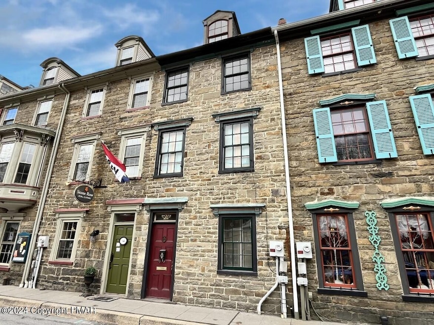
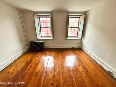
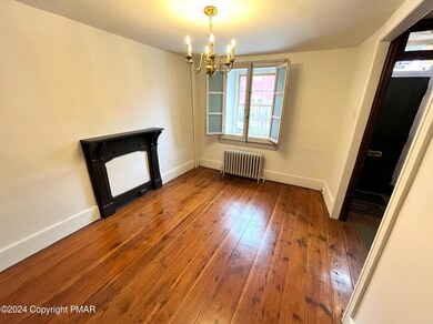
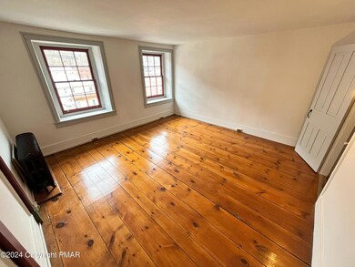
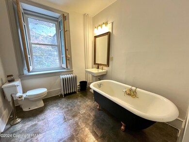
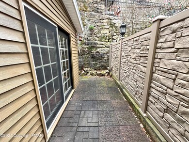
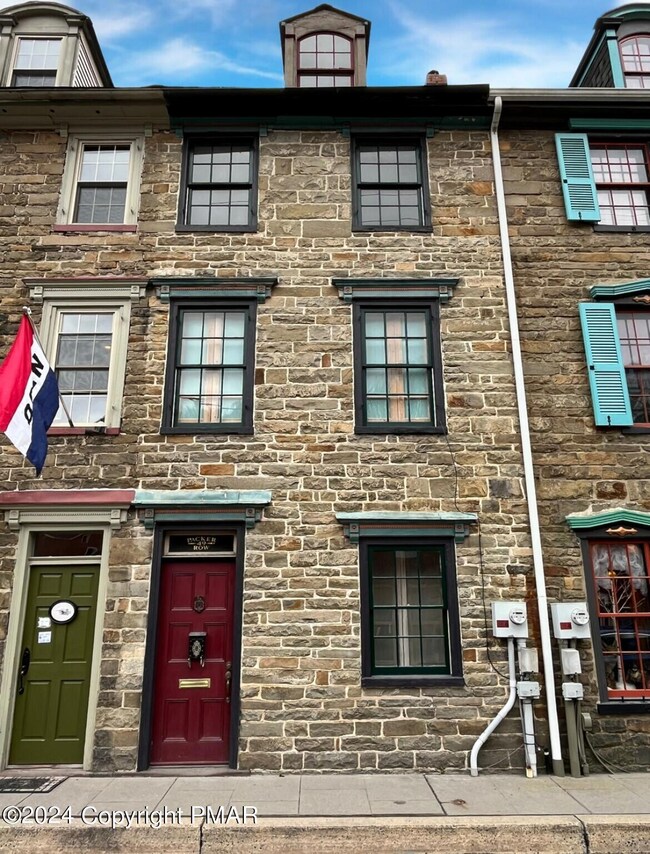
Gorgeous 5 bed/1 bath STONE ROW property for sale in the heart of historic downtown Jim Thorpe - walk out your front door to shops, restaurants, & more! As you enter you will immediately notice the lovingly restored hardwood floors throughout! 1st fl features a living room, formal dining room, & kitchen w/ sliders to the rear courtyard! Spacious 2nd fl front bedroom provides excellent flex space for an additional living area! The bathroom features a clawfoot tub & separate shower! Economical natural gas heat! Charming rear courtyard provides an enchanting ambiance w/ rear stone wall! This property provides a great opportunity to open a shop on the 1st floor & live above (w/ JT Borough approval)! Enjoy downtown living's benefits - Mauch Chunk Opera House, train station, D&L Trail, & more!
Last Agent to Sell the Property
Bear Mountain Real Estate LLC License #RM423608 Listed on: 03/19/2024
Last Buyer's Agent
Bear Mountain Real Estate LLC License #RM423608 Listed on: 03/19/2024
| Date | Buyer | Sale Price | Title Company |
|---|---|---|---|
| Ciconte Robert | $329,200 | First American Title | |
| 65 High Street Llc | $250 | Roberti Anthony | |
| Rodriguez Cuesta Manuel E | $205,000 | None Available |
| Date | Status | Borrower | Loan Amount |
|---|---|---|---|
| Previous Owner | Rodriguez Cuesta Manuel E | $164,000 |
| Date | Event | Price | List to Sale | Price per Sq Ft |
|---|---|---|---|---|
| 05/02/2024 05/02/24 | Sold | $329,200 | -8.5% | $207 / Sq Ft |
| 03/31/2024 03/31/24 | Pending | -- | -- | -- |
| 03/19/2024 03/19/24 | For Sale | $359,900 | -- | $226 / Sq Ft |
| Year | Tax Paid | Tax Assessment Tax Assessment Total Assessment is a certain percentage of the fair market value that is determined by local assessors to be the total taxable value of land and additions on the property. | Land | Improvement |
|---|---|---|---|---|
| 2025 | $4,341 | $54,688 | $4,233 | $50,455 |
| 2024 | $4,177 | $54,688 | $4,233 | $50,455 |
| 2023 | $4,101 | $54,688 | $4,233 | $50,455 |
| 2022 | $4,035 | $54,688 | $4,233 | $50,455 |
| 2021 | $4,035 | $54,688 | $4,233 | $50,455 |
| 2020 | $3,895 | $54,688 | $4,233 | $50,455 |
| 2019 | $3,786 | $54,688 | $4,233 | $50,455 |
| 2018 | $3,701 | $54,688 | $4,233 | $50,455 |
| 2017 | $3,591 | $54,688 | $4,233 | $50,455 |
| 2016 | -- | $54,688 | $4,233 | $50,455 |
| 2015 | -- | $54,688 | $4,233 | $50,455 |
| 2014 | -- | $54,688 | $4,233 | $50,455 |
R
Seller's Agent in 2024
Ronald Dunbar
Bear Mountain Real Estate LLC
(570) 325-3300
85 in this area
459 Total Sales
M
Seller Co-Listing Agent in 2024
Matthew Dunbar
Bear Mountain Real Estate LLC
(570) 325-3300
52 in this area
332 Total Sales
Source: Pocono Mountains Association of REALTORS®
MLS Number: PM-113606
APN: 83A2-17-F9
Disclaimer: Certain information contained herein is derived from information provided by parties other than Homes.com. All information provided is deemed reliable, but is not guaranteed to be accurate and should be independently verified.
![]() The data relating to real estate for sale on this web site includes listings held by MLS-IDX Participants of the Internet Data Exchange program of the Multiple Listing Service of the Pocono Mountains Association of Realtors®. Listings marked with the Internet Data Exchange logo are not necessarilty the listings of the owner of this web site. All listing data is the copyrighted property of the aforesaid Associations and its MLS-IDX Participants with all rights reserved. The information contained herein is believed to be accurate, but no warranty as such is expressed or implied.
The data relating to real estate for sale on this web site includes listings held by MLS-IDX Participants of the Internet Data Exchange program of the Multiple Listing Service of the Pocono Mountains Association of Realtors®. Listings marked with the Internet Data Exchange logo are not necessarilty the listings of the owner of this web site. All listing data is the copyrighted property of the aforesaid Associations and its MLS-IDX Participants with all rights reserved. The information contained herein is believed to be accurate, but no warranty as such is expressed or implied.
