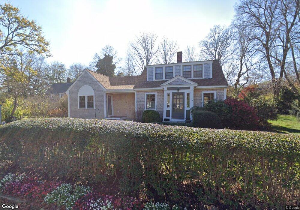
49 Ransom Rd Falmouth, MA 02540
Falmouth Village NeighborhoodEstimated Value: $906,000 - $1,126,000
3
Beds
3
Baths
1,639
Sq Ft
$631/Sq Ft
Est. Value
About This Home
This home is located at 49 Ransom Rd, Falmouth, MA 02540 and is currently estimated at $1,034,282, approximately $631 per square foot. 49 Ransom Rd is a home located in Barnstable County with nearby schools including Mullen-Hall School, Lawrence School, and Morse Pond School.
Ownership History
Date
Name
Owned For
Owner Type
Purchase Details
Closed on
Nov 21, 2024
Sold by
Kerfoot William B and Kerfoot Patricia H
Bought by
William B Kerfoot Ret and Kerfoot
Current Estimated Value
Purchase Details
Closed on
Feb 21, 1974
Bought by
Kerfoot William B and Kerfoot Patricia H
Create a Home Valuation Report for This Property
The Home Valuation Report is an in-depth analysis detailing your home's value as well as a comparison with similar homes in the area
Home Values in the Area
Average Home Value in this Area
Purchase History
| Date | Buyer | Sale Price | Title Company |
|---|---|---|---|
| William B Kerfoot Ret | -- | None Available | |
| William B Kerfoot Ret | -- | None Available | |
| Kerfoot William B | -- | -- |
Source: Public Records
Tax History Compared to Growth
Tax History
| Year | Tax Paid | Tax Assessment Tax Assessment Total Assessment is a certain percentage of the fair market value that is determined by local assessors to be the total taxable value of land and additions on the property. | Land | Improvement |
|---|---|---|---|---|
| 2025 | $5,073 | $864,200 | $435,700 | $428,500 |
| 2024 | $4,931 | $785,200 | $396,100 | $389,100 |
| 2023 | $4,499 | $650,100 | $316,800 | $333,300 |
| 2022 | $4,223 | $524,600 | $262,300 | $262,300 |
| 2021 | $4,092 | $481,400 | $250,900 | $230,500 |
| 2020 | $3,939 | $458,600 | $228,100 | $230,500 |
| 2019 | $3,643 | $425,600 | $228,100 | $197,500 |
| 2018 | $3,087 | $359,000 | $228,100 | $130,900 |
| 2017 | $3,026 | $354,700 | $228,100 | $126,600 |
| 2016 | $2,969 | $354,700 | $228,100 | $126,600 |
| 2015 | $2,905 | $354,700 | $228,100 | $126,600 |
| 2014 | $2,888 | $354,300 | $228,200 | $126,100 |
Source: Public Records
Map
Nearby Homes
- 38 Landfall Unit 38
- 38 Landfall
- 251 Woods Hole Rd
- 44 Carey Ln
- 87 Oyster Pond Rd
- 45 Haynes Ave
- 15 Hedge Ln
- 27 Upland Ave
- 76 F r Lillie Rd
- 29 Wilson Rd
- 71 Main St
- 65 Walker St
- 98 Main St
- 98 Main St Unit 1
- 30 Katherine Lee Bates Rd
- 33 Oakwood Ave
- 54 Whitman Rd
- 5 Park Rd
- 10 Shanks Pond Rd
- 10 Quissett Ave