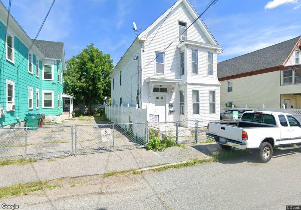
49 Royal St Lowell, MA 01851
Lower Highlands NeighborhoodEstimated Value: $555,073 - $679,000
5
Beds
2
Baths
2,960
Sq Ft
$208/Sq Ft
Est. Value
About This Home
This home is located at 49 Royal St, Lowell, MA 01851 and is currently estimated at $614,518, approximately $207 per square foot. 49 Royal St is a home located in Middlesex County with nearby schools including Abraham Lincoln Elementary School, Charles W. Morey Elementary School, and Charlotte M. Murkland Elementary School.
Ownership History
Date
Name
Owned For
Owner Type
Purchase Details
Closed on
Dec 2, 1997
Sold by
Aj Rt and Apostolos George J
Bought by
Chhoeun Roeuth
Current Estimated Value
Home Financials for this Owner
Home Financials are based on the most recent Mortgage that was taken out on this home.
Original Mortgage
$61,200
Outstanding Balance
$10,381
Interest Rate
7.26%
Mortgage Type
Purchase Money Mortgage
Estimated Equity
$604,137
Purchase Details
Closed on
Aug 4, 1994
Sold by
Hamilton George W
Bought by
Apostolos George J
Home Financials for this Owner
Home Financials are based on the most recent Mortgage that was taken out on this home.
Original Mortgage
$33,000
Interest Rate
8.4%
Mortgage Type
Purchase Money Mortgage
Create a Home Valuation Report for This Property
The Home Valuation Report is an in-depth analysis detailing your home's value as well as a comparison with similar homes in the area
Home Values in the Area
Average Home Value in this Area
Purchase History
| Date | Buyer | Sale Price | Title Company |
|---|---|---|---|
| Chhoeun Roeuth | $68,000 | -- | |
| Chhoeun Roeuth | $68,000 | -- | |
| Apostolos George J | $31,500 | -- | |
| Apostolos George J | $31,500 | -- |
Source: Public Records
Mortgage History
| Date | Status | Borrower | Loan Amount |
|---|---|---|---|
| Open | Apostolos George J | $61,200 | |
| Closed | Apostolos George J | $61,200 | |
| Previous Owner | Apostolos George J | $34,500 | |
| Previous Owner | Apostolos George J | $33,000 |
Source: Public Records
Tax History Compared to Growth
Tax History
| Year | Tax Paid | Tax Assessment Tax Assessment Total Assessment is a certain percentage of the fair market value that is determined by local assessors to be the total taxable value of land and additions on the property. | Land | Improvement |
|---|---|---|---|---|
| 2025 | $6,005 | $523,100 | $110,400 | $412,700 |
| 2024 | $5,571 | $467,800 | $103,100 | $364,700 |
| 2023 | $5,184 | $417,400 | $89,700 | $327,700 |
| 2022 | $4,660 | $367,200 | $70,900 | $296,300 |
| 2021 | $4,319 | $320,900 | $61,600 | $259,300 |
| 2020 | $4,016 | $300,600 | $61,600 | $239,000 |
| 2019 | $3,722 | $265,100 | $58,600 | $206,500 |
| 2018 | $3,462 | $240,600 | $55,800 | $184,800 |
| 2017 | $3,323 | $222,700 | $54,100 | $168,600 |
| 2016 | $3,319 | $218,900 | $50,300 | $168,600 |
| 2015 | $3,053 | $197,200 | $50,300 | $146,900 |
| 2013 | $2,781 | $185,300 | $60,300 | $125,000 |
Source: Public Records
Map
Nearby Homes
- 27 Royal St
- 45 Marshall St
- 173 Westford St
- 28 Grand St
- 42 Branch St
- 21 Kimball Ave
- 201 Thorndike St Unit 2-05
- 201 Thorndike St Unit 501
- 201 Thorndike St Unit 2-312
- 195 Thorndike St Unit 4
- 84 Cambridge St
- 490 School St Unit 2
- 100 Lane St
- 95 S Highland St
- 491 Dutton St Unit 320
- 491 Dutton St Unit 403
- 491 Dutton St Unit 415
- 491 Dutton St Unit 502
- 491 Dutton St Unit 504
- 710 School St