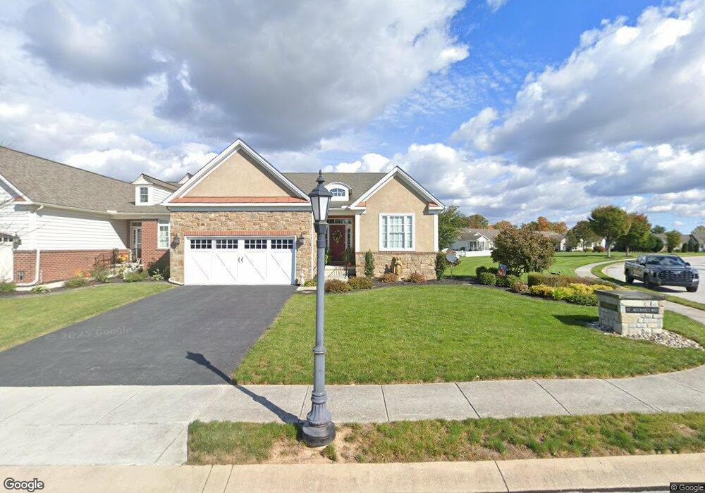
49 Saint Michaels Way Hanover, PA 17331
Estimated Value: $382,563 - $489,000
2
Beds
2
Baths
1,829
Sq Ft
$233/Sq Ft
Est. Value
About This Home
This home is located at 49 Saint Michaels Way, Hanover, PA 17331 and is currently estimated at $425,391, approximately $232 per square foot. 49 Saint Michaels Way is a home located in Adams County with nearby schools including New Oxford Senior High School, St. Teresa of Calcutta Catholic School - McSherrystown Campus, and St. Teresa of Calcutta Catholic School - Conewago Campus.
Ownership History
Date
Name
Owned For
Owner Type
Purchase Details
Closed on
Jan 21, 2014
Sold by
Harvest Investment Group Llc
Bought by
Poist John D and Poist Barbara S
Current Estimated Value
Create a Home Valuation Report for This Property
The Home Valuation Report is an in-depth analysis detailing your home's value as well as a comparison with similar homes in the area
Home Values in the Area
Average Home Value in this Area
Purchase History
| Date | Buyer | Sale Price | Title Company |
|---|---|---|---|
| Poist John D | $279,900 | None Available |
Source: Public Records
Tax History Compared to Growth
Tax History
| Year | Tax Paid | Tax Assessment Tax Assessment Total Assessment is a certain percentage of the fair market value that is determined by local assessors to be the total taxable value of land and additions on the property. | Land | Improvement |
|---|---|---|---|---|
| 2025 | $6,899 | $288,100 | $56,300 | $231,800 |
| 2024 | $6,373 | $288,100 | $56,300 | $231,800 |
| 2023 | $6,137 | $288,100 | $56,300 | $231,800 |
| 2022 | $5,949 | $288,100 | $56,300 | $231,800 |
| 2021 | $5,797 | $288,100 | $56,300 | $231,800 |
| 2020 | $5,805 | $288,100 | $56,300 | $231,800 |
| 2019 | $5,545 | $288,100 | $56,300 | $231,800 |
| 2018 | $5,428 | $288,100 | $56,300 | $231,800 |
| 2017 | $5,204 | $288,100 | $56,300 | $231,800 |
| 2016 | -- | $288,100 | $56,300 | $231,800 |
| 2015 | -- | $288,100 | $56,300 | $231,800 |
| 2014 | -- | $0 | $0 | $0 |
Source: Public Records
Map
Nearby Homes
- 152 St Michaels Way Unit 18
- 51 Michael St Unit 6
- 124 Flint Dr Unit 61
- 105 Flint Dr
- 108 Flint Dr
- 5955 Hanover Rd
- 73 Flint Dr
- 11 Flint Dr
- 24 Red Stone Ln Unit 47
- 62 Flint Dr
- 11 Shawl Dr
- 54 Flint Dr
- 46 Flint Dr
- 84 Red Stone Ln Unit 41
- 92 Red Stone Ln Unit 40
- 3211 Centennial Rd
- 9 Westview Dr Unit 2A
- 49 North St
- 1 Sease Dr Unit 1
- 128 North St
- 49 St Michaels Way Unit 35
- 49 St Michaels Way
- 55 Saint Michaels Way
- 55 St Michaels Way
- 77 St Michaels Way Unit 37
- 2 St Michaels Way
- 95 Saint Michaels Way
- 50 St Michaels Way Unit 1
- 50 St Michaels Way
- 56 St Michaels Way Unit 2
- 115 Saint Michaels Way
- 62 St Michaels Way Unit 3
- 115 St Michaels Way Unit 39
- 36 St Michaels Way Unit 34
- 36 St Michaels Way
- 36 Saint Michaels Way
- 125 St Michaels Way Unit 41
- 95 St Michaels Way Unit 38
- 30 St Michaels Way Unit 33
- 30 St Michaels Way