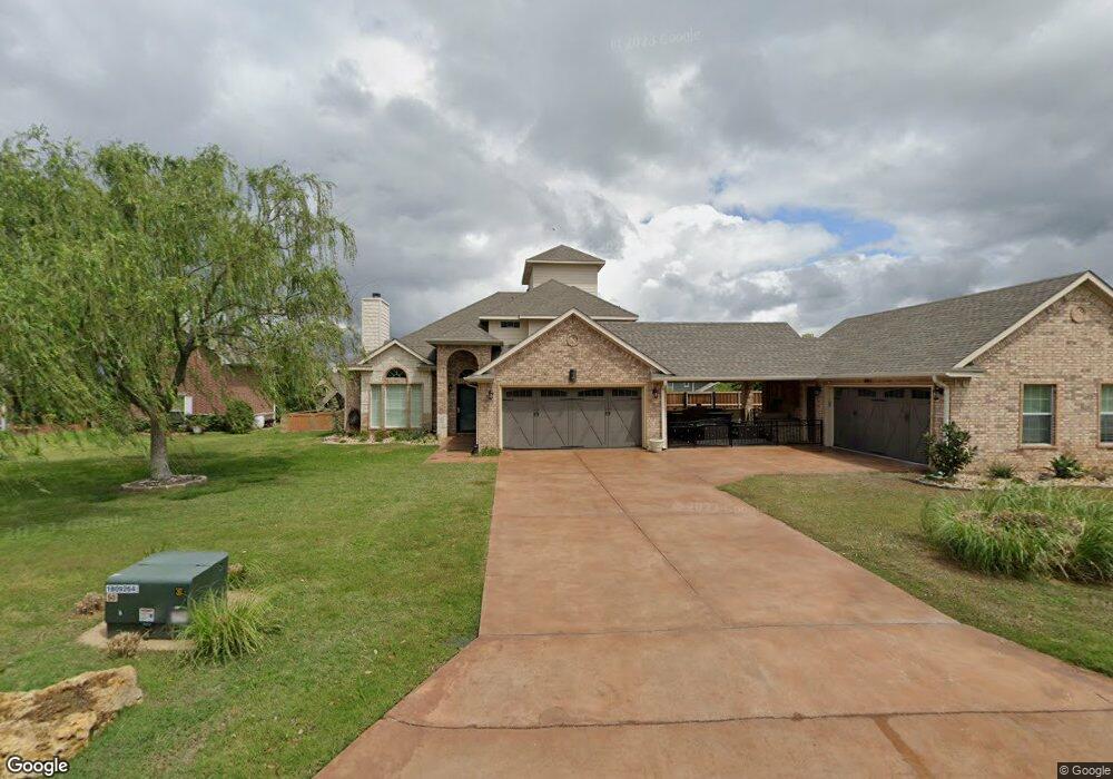
49 Sunrise Cir Pottsboro, TX 75076
Estimated Value: $572,332 - $681,000
3
Beds
3
Baths
2,547
Sq Ft
$237/Sq Ft
Est. Value
About This Home
This home is located at 49 Sunrise Cir, Pottsboro, TX 75076 and is currently estimated at $604,583, approximately $237 per square foot. 49 Sunrise Cir is a home located in Grayson County with nearby schools including Pottsboro Elementary School, Pottsboro Middle School, and Pottsboro High School.
Ownership History
Date
Name
Owned For
Owner Type
Purchase Details
Closed on
Apr 21, 2017
Sold by
Murphy Robert
Bought by
Pease Bryan and Pease Elizabeth
Current Estimated Value
Home Financials for this Owner
Home Financials are based on the most recent Mortgage that was taken out on this home.
Original Mortgage
$292,500
Outstanding Balance
$243,404
Interest Rate
4.21%
Mortgage Type
New Conventional
Estimated Equity
$361,179
Create a Home Valuation Report for This Property
The Home Valuation Report is an in-depth analysis detailing your home's value as well as a comparison with similar homes in the area
Home Values in the Area
Average Home Value in this Area
Purchase History
| Date | Buyer | Sale Price | Title Company |
|---|---|---|---|
| Pease Bryan | -- | Red River Title |
Source: Public Records
Mortgage History
| Date | Status | Borrower | Loan Amount |
|---|---|---|---|
| Open | Pease Bryan | $292,500 |
Source: Public Records
Tax History Compared to Growth
Tax History
| Year | Tax Paid | Tax Assessment Tax Assessment Total Assessment is a certain percentage of the fair market value that is determined by local assessors to be the total taxable value of land and additions on the property. | Land | Improvement |
|---|---|---|---|---|
| 2025 | $5,042 | $501,262 | -- | -- |
| 2024 | $6,314 | $455,693 | $0 | $0 |
| 2023 | $4,489 | $414,266 | $0 | $0 |
| 2022 | $5,927 | $376,605 | $0 | $0 |
| 2021 | $5,285 | $324,956 | $82,989 | $241,967 |
| 2020 | $4,810 | $284,943 | $46,240 | $238,703 |
| 2019 | $5,133 | $290,114 | $46,240 | $243,874 |
| 2018 | $5,029 | $280,726 | $78,740 | $201,986 |
| 2017 | $5,956 | $328,169 | $78,740 | $249,429 |
| 2016 | $5,628 | $310,087 | $63,620 | $246,467 |
| 2015 | $4,805 | $260,085 | $63,620 | $196,465 |
| 2014 | $3,780 | $313,411 | $63,620 | $249,791 |
Source: Public Records
Map
Nearby Homes
- 128 Bridlepath Dr
- 65 Lakewood Ln
- 91 Shadow Ln
- 2116 Tanglewood Blvd Unit A2003
- TBD 881-3 Tanglewood Trail
- 0000 Tanglewood Trail
- TBD 881-4 Tanglewood Trail
- 271 Lakewood Ln
- 399 Tanglewood Trail
- 2164 Tanglewood Blvd Unit A208
- 2164 Tanglewood Blvd Unit 115
- 2164 Tanglewood Blvd Unit 207
- 2164 Tanglewood Blvd Unit 215
- 2164 Tanglewood Blvd Unit 309
- 2164 Tanglewood Blvd Unit 308
- 2164 Tanglewood Blvd Unit 104
- 2164 Tanglewood Blvd Unit 210
- 355 Lakecrest Dr
- 188 Hacienda Dr
- 118 Hacienda Dr
- 23 Sunrise Cir
- 77 Sunrise Cir
- 1921 Tanglewood Blvd
- 759 Lakecrest Dr
- 737 Lakecrest Dr
- 83 Sunrise Cir
- 717 Lakecrest Dr
- 30 Idlewild Dr
- 801 Lakecrest Dr
- 1988 Tanglewood Blvd
- 26 Oak Knoll Dr
- 49 Oak Knoll Dr
- TBD Idlewild Dr
- 7 Oak Knoll Dr
- 52 Idlewild Dr
- 101 Oak Knoll Dr
- 662 Lakecrest Dr
- 122 North Meadows
- 86 Oak Knoll Dr
- 853 Lakecrest Dr