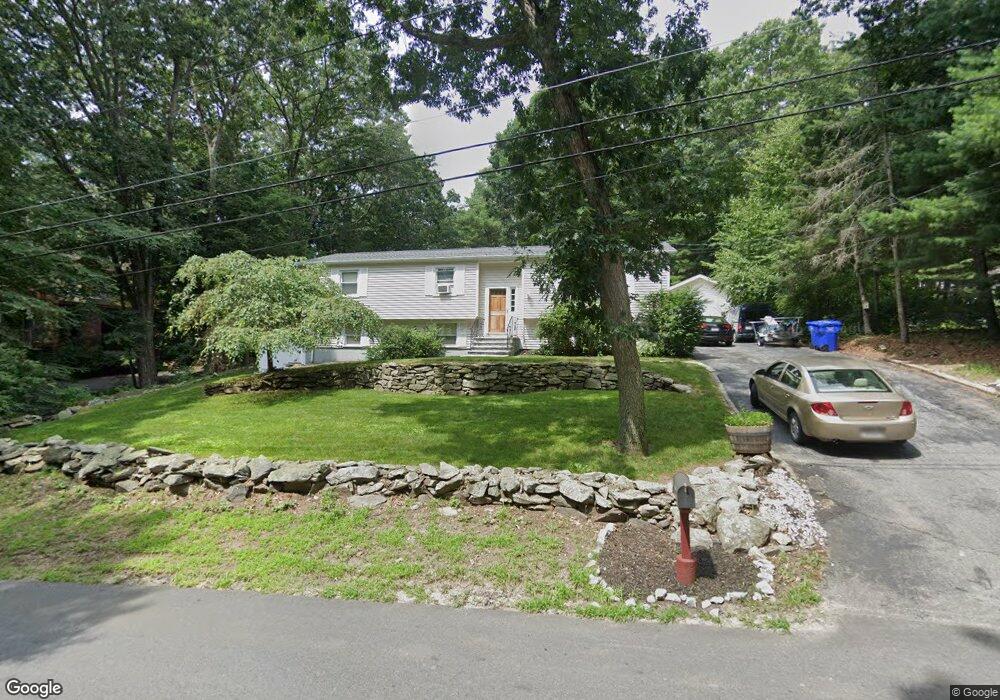
49 Warren St Boylston, MA 01505
Estimated Value: $496,068 - $662,000
3
Beds
2
Baths
1,196
Sq Ft
$480/Sq Ft
Est. Value
About This Home
This home is located at 49 Warren St, Boylston, MA 01505 and is currently estimated at $573,517, approximately $479 per square foot. 49 Warren St is a home located in Worcester County with nearby schools including Tahanto Regional High School and Cornerstone Academy.
Ownership History
Date
Name
Owned For
Owner Type
Purchase Details
Closed on
Aug 3, 2022
Sold by
Desouza Michelle
Bought by
Souza Michelle and Desouza Carlos
Current Estimated Value
Purchase Details
Closed on
Apr 11, 2008
Sold by
Souza Michelle and Desouza Carlos
Bought by
Desouza Michelle
Purchase Details
Closed on
Jun 1, 2005
Sold by
Wiggin Bruce E and Wiggin Carol A
Bought by
Desouza Carlos H
Home Financials for this Owner
Home Financials are based on the most recent Mortgage that was taken out on this home.
Original Mortgage
$238,000
Interest Rate
5.83%
Mortgage Type
Purchase Money Mortgage
Purchase Details
Closed on
Apr 12, 2002
Sold by
Ohara Terrance P and Ohara Lisa A
Bought by
Hays Markm and Hays Christy M
Home Financials for this Owner
Home Financials are based on the most recent Mortgage that was taken out on this home.
Original Mortgage
$232,900
Interest Rate
6.84%
Mortgage Type
Purchase Money Mortgage
Create a Home Valuation Report for This Property
The Home Valuation Report is an in-depth analysis detailing your home's value as well as a comparison with similar homes in the area
Home Values in the Area
Average Home Value in this Area
Purchase History
| Date | Buyer | Sale Price | Title Company |
|---|---|---|---|
| Souza Michelle | -- | None Available | |
| Desouza Michelle | -- | -- | |
| Desouza Carlos H | $297,500 | -- | |
| Hays Markm | $264,900 | -- |
Source: Public Records
Mortgage History
| Date | Status | Borrower | Loan Amount |
|---|---|---|---|
| Previous Owner | Desouza Carlos H | $238,000 | |
| Previous Owner | Hays Markm | $232,900 | |
| Previous Owner | Hays Markm | $131,000 | |
| Previous Owner | Hays Markm | $50,000 | |
| Previous Owner | Hays Markm | $25,000 |
Source: Public Records
Tax History Compared to Growth
Tax History
| Year | Tax Paid | Tax Assessment Tax Assessment Total Assessment is a certain percentage of the fair market value that is determined by local assessors to be the total taxable value of land and additions on the property. | Land | Improvement |
|---|---|---|---|---|
| 2025 | $5,514 | $398,700 | $166,400 | $232,300 |
| 2024 | $5,364 | $388,400 | $166,400 | $222,000 |
| 2023 | $5,301 | $368,100 | $166,400 | $201,700 |
| 2022 | $4,795 | $302,700 | $166,400 | $136,300 |
| 2021 | $4,906 | $288,900 | $166,400 | $122,500 |
| 2020 | $4,568 | $276,200 | $159,300 | $116,900 |
| 2019 | $4,326 | $269,700 | $157,400 | $112,300 |
| 2018 | $4,423 | $264,400 | $157,400 | $107,000 |
| 2017 | $4,262 | $264,400 | $157,400 | $107,000 |
| 2016 | $3,917 | $239,300 | $123,600 | $115,700 |
| 2015 | $4,166 | $239,300 | $123,600 | $115,700 |
| 2014 | $3,873 | $222,700 | $112,400 | $110,300 |
Source: Public Records
Map
Nearby Homes