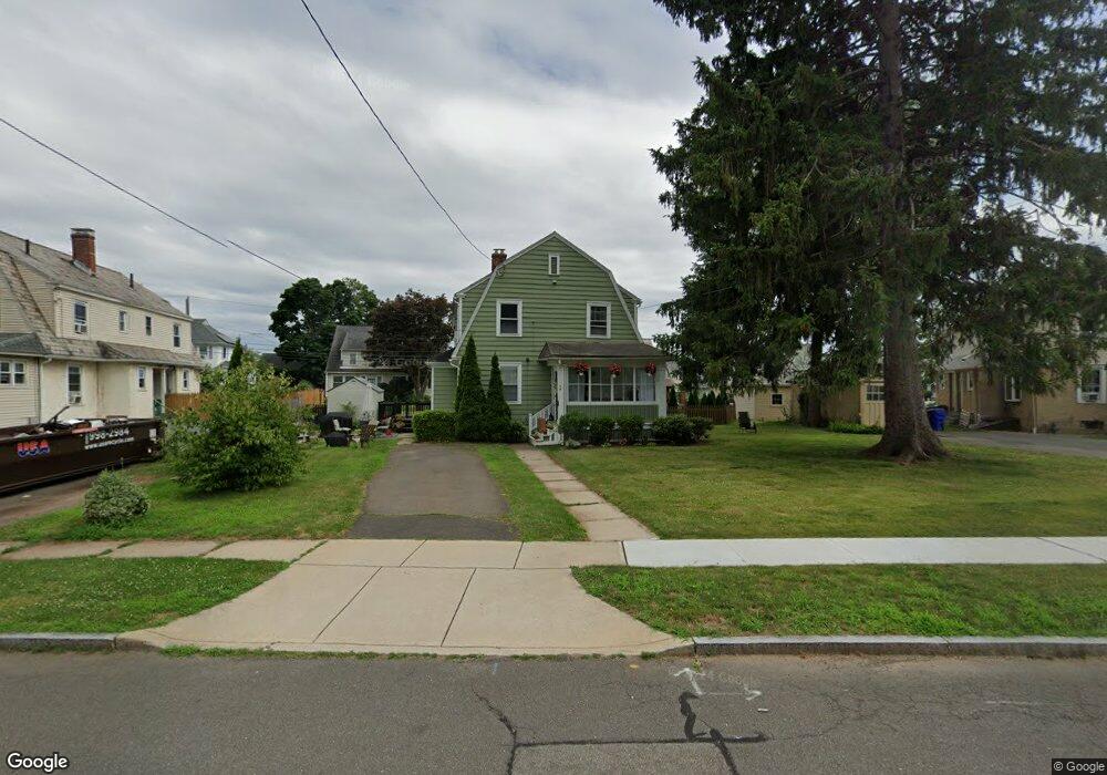
49 Washington Cir West Hartford, CT 06119
Estimated Value: $241,000 - $326,000
3
Beds
1
Bath
1,113
Sq Ft
$264/Sq Ft
Est. Value
About This Home
This home is located at 49 Washington Cir, West Hartford, CT 06119 and is currently estimated at $293,453, approximately $263 per square foot. 49 Washington Cir is a home located in Hartford County with nearby schools including Whiting Lane School, Adams Elementary School, and King Philip Middle School.
Ownership History
Date
Name
Owned For
Owner Type
Purchase Details
Closed on
May 13, 2005
Sold by
Erickson Dean R and Erickson Anne B
Bought by
Baker Damion A and Erickson Katrina A
Current Estimated Value
Home Financials for this Owner
Home Financials are based on the most recent Mortgage that was taken out on this home.
Original Mortgage
$116,471
Outstanding Balance
$61,546
Interest Rate
6.05%
Estimated Equity
$231,907
Create a Home Valuation Report for This Property
The Home Valuation Report is an in-depth analysis detailing your home's value as well as a comparison with similar homes in the area
Home Values in the Area
Average Home Value in this Area
Purchase History
| Date | Buyer | Sale Price | Title Company |
|---|---|---|---|
| Baker Damion A | $135,000 | -- |
Source: Public Records
Mortgage History
| Date | Status | Borrower | Loan Amount |
|---|---|---|---|
| Open | Baker Damion A | $116,471 |
Source: Public Records
Tax History Compared to Growth
Tax History
| Year | Tax Paid | Tax Assessment Tax Assessment Total Assessment is a certain percentage of the fair market value that is determined by local assessors to be the total taxable value of land and additions on the property. | Land | Improvement |
|---|---|---|---|---|
| 2025 | $5,169 | $115,420 | $43,600 | $71,820 |
| 2024 | $4,888 | $115,420 | $43,600 | $71,820 |
| 2023 | $4,723 | $115,420 | $43,600 | $71,820 |
| 2022 | $4,695 | $115,420 | $43,600 | $71,820 |
| 2021 | $3,156 | $74,410 | $39,600 | $34,810 |
| 2020 | $3,110 | $74,410 | $34,000 | $40,410 |
| 2019 | $3,110 | $74,410 | $33,950 | $40,460 |
| 2018 | $3,051 | $74,410 | $33,950 | $40,460 |
| 2017 | $3,054 | $74,410 | $33,950 | $40,460 |
| 2016 | $4,099 | $103,740 | $45,920 | $57,820 |
| 2015 | $3,974 | $103,740 | $45,920 | $57,820 |
| 2014 | $3,877 | $103,740 | $45,920 | $57,820 |
Source: Public Records
Map
Nearby Homes
- 89 Price Blvd
- 50 Acadia St
- 39 Fairlawn St
- 102 Oakwood Ave Unit B5
- 30 Outlook Ave Unit 205
- 72 Saint Charles St
- 869 Farmington Ave Unit 305
- 16 Lilley Rd
- 136 Kane St Unit B10
- 21 Warren Terrace
- 61 Woodmere Rd
- 16 Lockwood Terrace
- 100 Kane St Unit D10
- 48 Walkley Rd
- 54 Robin Rd Unit B2
- 26 Saint Augustine St
- 69 Saint Augustine St
- 478 Prospect Ave
- 85 Memorial Rd Unit 512
- 1006A Trout Brook Dr Unit 1006A
- 104 Washington Cir
- 34 Washington Cir
- 57 Washington Cir
- 57 Washington Cir Unit 2
- 57 Washington Cir
- 112 Washington Cir
- 32 Washington Cir
- 50 Washington Cir
- 48 Washington Cir
- 54 Washington Cir
- 44 Washington Cir
- 56 Washington Cir
- 118 Washington Cir
- 107 Washington Cir
- 101 Washington Cir
- 60 Washington Cir
- 109 Washington Cir
- 99 Washington Cir
- 41 Washington Cir
- 18 Washington Cir