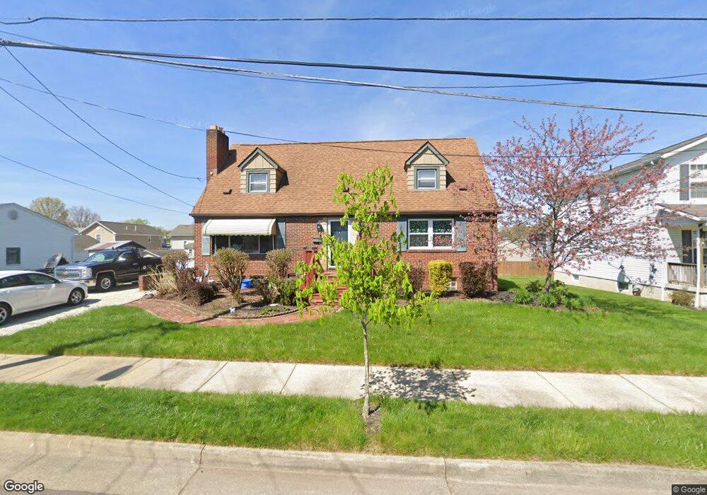
490 Boyd Ave Akron, OH 44305
Goodyear Heights NeighborhoodEstimated Value: $163,000 - $187,000
4
Beds
2
Baths
1,492
Sq Ft
$116/Sq Ft
Est. Value
About This Home
This home is located at 490 Boyd Ave, Akron, OH 44305 and is currently estimated at $173,093, approximately $116 per square foot. 490 Boyd Ave is a home located in Summit County with nearby schools including Ellet High School, Summit Academy Akron Elementary School, and Middlebury Academy.
Ownership History
Date
Name
Owned For
Owner Type
Purchase Details
Closed on
Nov 3, 2010
Sold by
Malish Jamie E and Malish Jonathan
Bought by
Mcintyre Kimberly E
Current Estimated Value
Home Financials for this Owner
Home Financials are based on the most recent Mortgage that was taken out on this home.
Original Mortgage
$87,875
Outstanding Balance
$58,273
Interest Rate
4.37%
Mortgage Type
New Conventional
Estimated Equity
$114,820
Purchase Details
Closed on
Feb 3, 2005
Sold by
Bolton Carol Ann
Bought by
Dyer Jamie E
Home Financials for this Owner
Home Financials are based on the most recent Mortgage that was taken out on this home.
Original Mortgage
$81,225
Interest Rate
5.83%
Mortgage Type
FHA
Purchase Details
Closed on
Jul 9, 2004
Sold by
Bolton Carol Ann
Bought by
Bolton Carol Ann and Estate Of Robert Carl Venham
Create a Home Valuation Report for This Property
The Home Valuation Report is an in-depth analysis detailing your home's value as well as a comparison with similar homes in the area
Home Values in the Area
Average Home Value in this Area
Purchase History
| Date | Buyer | Sale Price | Title Company |
|---|---|---|---|
| Mcintyre Kimberly E | $92,500 | Attorney | |
| Dyer Jamie E | $82,500 | Approved Statewide Title Age | |
| Bolton Carol Ann | -- | Bond & Associates Title Agen |
Source: Public Records
Mortgage History
| Date | Status | Borrower | Loan Amount |
|---|---|---|---|
| Open | Mcintyre Kimberly E | $87,875 | |
| Previous Owner | Dyer Jamie E | $81,225 |
Source: Public Records
Tax History Compared to Growth
Tax History
| Year | Tax Paid | Tax Assessment Tax Assessment Total Assessment is a certain percentage of the fair market value that is determined by local assessors to be the total taxable value of land and additions on the property. | Land | Improvement |
|---|---|---|---|---|
| 2025 | $2,366 | $44,867 | $9,653 | $35,214 |
| 2024 | $2,366 | $44,867 | $9,653 | $35,214 |
| 2023 | $2,366 | $44,867 | $9,653 | $35,214 |
| 2022 | $1,955 | $28,946 | $6,227 | $22,719 |
| 2021 | $1,957 | $28,946 | $6,227 | $22,719 |
| 2020 | $1,927 | $28,950 | $6,230 | $22,720 |
| 2019 | $2,134 | $29,230 | $6,040 | $23,190 |
| 2018 | $2,105 | $29,230 | $6,040 | $23,190 |
| 2017 | $2,139 | $29,230 | $6,040 | $23,190 |
| 2016 | $2,140 | $29,230 | $6,040 | $23,190 |
| 2015 | $2,139 | $29,230 | $6,040 | $23,190 |
| 2014 | $2,121 | $29,230 | $6,040 | $23,190 |
| 2013 | $2,172 | $30,600 | $6,040 | $24,560 |
Source: Public Records
Map
Nearby Homes
- 2216 Eastlawn Ave
- 428 Seaman Ave
- 522 Lamont St
- 2076 Congo St
- 382 Larkin Ave
- 2352 Newton St
- 2356 Newton St
- 287 E Park Blvd
- 2360 Newton St
- 359 Booth Ave
- 333 Cluster Ave
- 360 Cluster Ave
- 2382 Mogadore Rd
- 2258 Mogadore Rd
- 469 Lodi St
- 2253 Tyro Ave
- 249 Malacca St
- 276 Malacca St
- 248 Malacca St
- 1892 Malasia Rd