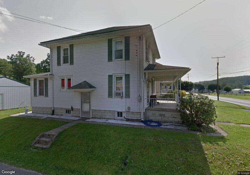
490 E Main St Thompsontown, PA 17094
Estimated Value: $62,388 - $201,000
3
Beds
2
Baths
1,248
Sq Ft
$122/Sq Ft
Est. Value
About This Home
This home is located at 490 E Main St, Thompsontown, PA 17094 and is currently estimated at $152,347, approximately $122 per square foot. 490 E Main St is a home located in Juniata County with nearby schools including East Juniata Elementary School, East Juniata Junior/Senior High School, and Delaware Creek School.
Ownership History
Date
Name
Owned For
Owner Type
Purchase Details
Closed on
May 8, 2012
Sold by
Lynch Sherry L and Mccurdy Sherry L
Bought by
Mccurdy Michael E and Mccurdy Sherry L
Current Estimated Value
Home Financials for this Owner
Home Financials are based on the most recent Mortgage that was taken out on this home.
Original Mortgage
$64,600
Interest Rate
3.88%
Mortgage Type
New Conventional
Purchase Details
Closed on
Apr 15, 2002
Bought by
Mccurdy Michael C and Mccurdy Sherry L
Create a Home Valuation Report for This Property
The Home Valuation Report is an in-depth analysis detailing your home's value as well as a comparison with similar homes in the area
Purchase History
| Date | Buyer | Sale Price | Title Company |
|---|---|---|---|
| Mccurdy Michael E | -- | None Available | |
| Mccurdy Michael C | $82,000 | -- |
Source: Public Records
Mortgage History
| Date | Status | Borrower | Loan Amount |
|---|---|---|---|
| Closed | Mccurdy Michael E | $64,600 |
Source: Public Records
Tax History
| Year | Tax Paid | Tax Assessment Tax Assessment Total Assessment is a certain percentage of the fair market value that is determined by local assessors to be the total taxable value of land and additions on the property. | Land | Improvement |
|---|---|---|---|---|
| 2025 | $1,432 | $12,320 | $1,100 | $11,220 |
| 2024 | $1,311 | $12,320 | $1,100 | $11,220 |
| 2023 | $1,268 | $12,320 | $1,100 | $11,220 |
| 2022 | $1,247 | $12,320 | $1,100 | $11,220 |
| 2021 | $1,207 | $12,320 | $1,100 | $11,220 |
| 2020 | $1,153 | $12,320 | $1,100 | $11,220 |
| 2019 | $1,151 | $12,320 | $1,100 | $11,220 |
| 2018 | $1,144 | $12,320 | $1,100 | $11,220 |
| 2017 | -- | $12,320 | $1,100 | $11,220 |
| 2016 | $1,085 | $12,320 | $1,100 | $11,220 |
| 2015 | -- | $12,320 | $1,100 | $11,220 |
| 2014 | -- | $9,360 | $1,100 | $8,260 |
Source: Public Records
Map
Nearby Homes
- 158 Farm Dr
- 33 W Main St
- 64 Metz Rd
- 320 Locust Run Rd
- 849 Sugar Run Rd
- 40 N Market St
- 25 S Market St
- 66 Brookview Dr
- 128 Wildcat Rd
- 207 Mill Race Rd
- 1703 Industrial Park Rd
- 7504 Raccoon Valley Rd
- 829 Pintail Dr
- 122 Wesson Ct
- 2291 Middle Ridge Rd
- 4201 Middle Ridge Rd
- 10678 Buffalo Trace
- US Route 322 and Rou Kauffman Ln
- 0 00 Gingerfield Drive (Lot 7&8)
- 67 S 2nd St
- 506 E Main St Unit 506
- 484 E Main St
- 466 E Main St
- 526 E Main St
- R R #1 Penn St Unit Box 332
- R R #1 Box 332 Penn St
- 54 Penn St
- 61 Penn St
- 546 E Main St
- 59 Harley Dr
- 438 E Main St
- 31 Juniata St
- 0 Juniata St Unit 1002748231
- 0 Juniata St Unit PAJT2005528
- 552 E Main St
- 49 Juniata St
- 29 Sparks Ln
- 2 Juniata St
- 80 Penn St
- 558 E Main St
Your Personal Tour Guide
Ask me questions while you tour the home.