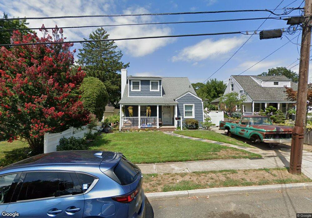
490 Grantland Ave West Hempstead, NY 11552
Estimated Value: $731,000 - $764,609
4
Beds
3
Baths
1,310
Sq Ft
$571/Sq Ft
Est. Value
About This Home
This home is located at 490 Grantland Ave, West Hempstead, NY 11552 and is currently estimated at $747,805, approximately $570 per square foot. 490 Grantland Ave is a home located in Nassau County with nearby schools including Chestnut Street School, West Hempstead Middle School, and West Hempstead Secondary School.
Ownership History
Date
Name
Owned For
Owner Type
Purchase Details
Closed on
Dec 3, 2012
Sold by
Klimkowsky Jane M and Klimkowsky Jane Margaret
Bought by
Irizarry John and Irizarry Michelle
Current Estimated Value
Home Financials for this Owner
Home Financials are based on the most recent Mortgage that was taken out on this home.
Original Mortgage
$322,059
Outstanding Balance
$221,446
Interest Rate
3.21%
Mortgage Type
FHA
Estimated Equity
$526,359
Purchase Details
Closed on
Sep 27, 2005
Sold by
Klimkowsky Jane
Create a Home Valuation Report for This Property
The Home Valuation Report is an in-depth analysis detailing your home's value as well as a comparison with similar homes in the area
Home Values in the Area
Average Home Value in this Area
Purchase History
| Date | Buyer | Sale Price | Title Company |
|---|---|---|---|
| Irizarry John | $328,000 | Advantage Title | |
| -- | -- | -- |
Source: Public Records
Mortgage History
| Date | Status | Borrower | Loan Amount |
|---|---|---|---|
| Open | Irizarry John | $322,059 |
Source: Public Records
Tax History Compared to Growth
Tax History
| Year | Tax Paid | Tax Assessment Tax Assessment Total Assessment is a certain percentage of the fair market value that is determined by local assessors to be the total taxable value of land and additions on the property. | Land | Improvement |
|---|---|---|---|---|
| 2025 | $12,947 | $485 | $217 | $268 |
| 2024 | $4,528 | $485 | $217 | $268 |
| 2023 | $12,311 | $485 | $217 | $268 |
| 2022 | $12,311 | $485 | $217 | $268 |
| 2021 | $16,925 | $463 | $207 | $256 |
| 2020 | $13,174 | $808 | $493 | $315 |
| 2019 | $13,584 | $808 | $493 | $315 |
| 2018 | $12,825 | $808 | $0 | $0 |
| 2017 | $7,239 | $808 | $493 | $315 |
| 2016 | $11,275 | $808 | $493 | $315 |
| 2015 | $3,591 | $771 | $493 | $278 |
| 2014 | $3,591 | $771 | $493 | $278 |
| 2013 | $3,362 | $771 | $493 | $278 |
Source: Public Records
Map
Nearby Homes
- 19 Richard St
- 23 Rhoda St
- 400 Langley Ave
- 613 Adams Ave
- 490 Walton Ct
- 199 Guildford Ct
- 635 Hempstead Ave
- 198 Guildford Ct
- 231 Wilson St
- 352 Hempstead Ave
- 279 Semton Blvd
- 594 Fenworth Blvd
- 306 Garfield Ave
- 670 Hempstead Ave
- 72 Munson Ave
- 688 Alton Rd
- 467 Susan Ct
- 268 Spruce St
- 72 Spruce St
- 149 Rule St
- 486 Grantland Ave
- 440 Mckinley St
- 450 Mckinley St
- 423 Roosevelt Blvd
- 480 Grantland Ave
- 427 Roosevelt Blvd
- 491 Grantland Ave
- 489 Grantland Ave
- 493 Grantland Ave
- 485 Grantland Ave
- 451 Mckinley St
- 447 Mckinley St
- 457 Mckinley St
- 443 Mckinley St
- 437 Roosevelt Blvd
- 501 Grantland Ave
- 463 Mckinley St
- 439 Mckinley St
- 469 Mckinley St
- 511 Grantland Ave