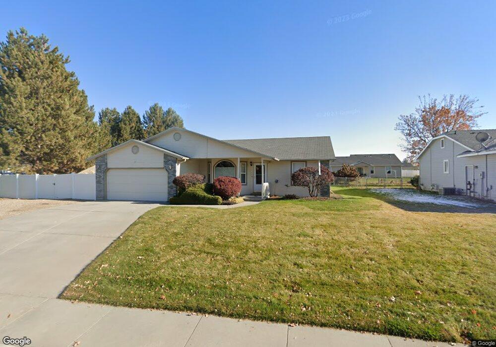
490 N 20th St Payette, ID 83661
Estimated Value: $375,000 - $396,000
4
Beds
2
Baths
1,756
Sq Ft
$218/Sq Ft
Est. Value
About This Home
This home is located at 490 N 20th St, Payette, ID 83661 and is currently estimated at $382,820, approximately $218 per square foot. 490 N 20th St is a home located in Payette County with nearby schools including Payette Primary School, Westside Elementary School, and McCain Middle School.
Ownership History
Date
Name
Owned For
Owner Type
Purchase Details
Closed on
Jan 8, 2026
Sold by
Godfrey Carolyn K
Bought by
Carolyn K Godfrey Family Trust and Godfrey
Current Estimated Value
Purchase Details
Closed on
Dec 2, 2025
Sold by
Clements Steven J
Bought by
Clements Lyn-Ann Brunson
Purchase Details
Closed on
Mar 10, 2009
Sold by
Roddy Joseph M and Roddy Karen G
Bought by
Amason S Elizabeth and Amason Kenneth W
Home Financials for this Owner
Home Financials are based on the most recent Mortgage that was taken out on this home.
Original Mortgage
$171,338
Interest Rate
5.03%
Mortgage Type
FHA
Create a Home Valuation Report for This Property
The Home Valuation Report is an in-depth analysis detailing your home's value as well as a comparison with similar homes in the area
Home Values in the Area
Average Home Value in this Area
Purchase History
| Date | Buyer | Sale Price | Title Company |
|---|---|---|---|
| Carolyn K Godfrey Family Trust | -- | Simplifile (Recording Service) | |
| Clements Lyn-Ann Brunson | -- | None Listed On Document | |
| Amason S Elizabeth | -- | -- |
Source: Public Records
Mortgage History
| Date | Status | Borrower | Loan Amount |
|---|---|---|---|
| Previous Owner | Amason S Elizabeth | $171,338 |
Source: Public Records
Tax History
| Year | Tax Paid | Tax Assessment Tax Assessment Total Assessment is a certain percentage of the fair market value that is determined by local assessors to be the total taxable value of land and additions on the property. | Land | Improvement |
|---|---|---|---|---|
| 2025 | $1,570 | $358,882 | $120,200 | $238,682 |
| 2024 | $1,488 | $351,736 | $112,700 | $239,036 |
| 2023 | $1,552 | $380,006 | $107,300 | $272,706 |
| 2022 | $2,090 | $383,101 | $107,300 | $275,801 |
| 2021 | $1,723 | $281,585 | $56,600 | $224,985 |
| 2020 | $1,361 | $208,830 | $27,180 | $181,650 |
| 2017 | $1,400 | $0 | $0 | $0 |
| 2016 | $1,340 | $0 | $0 | $0 |
| 2015 | $1,541 | $141,852 | $23,400 | $118,452 |
| 2014 | $1,429 | $118,160 | $23,400 | $94,760 |
Source: Public Records
Map
Nearby Homes
- 226 N 21st St
- 2061 Uehlin Dr
- 129 Country Lane Loop
- 10545 N Iowa Ave
- TBD U S Route 95
- 395 Cutlass St
- TBD Hwy 95
- 1602 2nd Ave S
- 3513 Highway 52
- 1440 Chaparral Way
- 316 N 11th St
- 215 Farber Dr
- TBD Consolidated Lot On Perry Dr
- 313 Sunrise Dr
- 2465 Augusta Ave
- L18-B6 Perry Dr
- L11-B6 Perry Dr
- 2585 NE 15th Ave
- 2560 NE 16th Ave
- 1825 NE 17th Ave
Your Personal Tour Guide
Ask me questions while you tour the home.