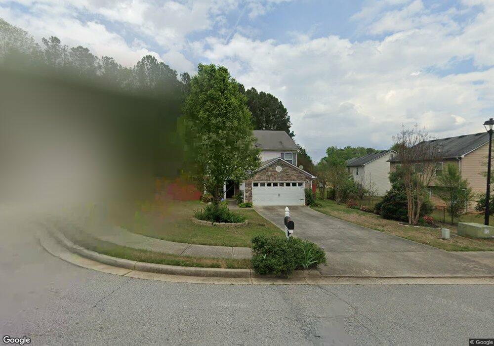
490 Rock Crest Dr Forest Park, GA 30297
Estimated Value: $258,000 - $316,000
4
Beds
3
Baths
2,110
Sq Ft
$134/Sq Ft
Est. Value
About This Home
This home is located at 490 Rock Crest Dr, Forest Park, GA 30297 and is currently estimated at $282,664, approximately $133 per square foot. 490 Rock Crest Dr is a home located in Clayton County with nearby schools including Forest Park Middle School, Forest Park High School, and Utopian Academy for the Arts Elementary School.
Ownership History
Date
Name
Owned For
Owner Type
Purchase Details
Closed on
Jul 23, 2010
Sold by
Strategic Holdings Group Llc
Bought by
Smith Ladonna
Current Estimated Value
Home Financials for this Owner
Home Financials are based on the most recent Mortgage that was taken out on this home.
Original Mortgage
$83,742
Outstanding Balance
$54,665
Interest Rate
4.37%
Mortgage Type
FHA
Estimated Equity
$227,999
Purchase Details
Closed on
May 13, 2010
Sold by
First Ga Cmnty Bk
Bought by
Strategic Holdings Group Llc
Home Financials for this Owner
Home Financials are based on the most recent Mortgage that was taken out on this home.
Original Mortgage
$96,000
Interest Rate
5%
Purchase Details
Closed on
Jun 2, 2009
Sold by
Clay Robertson Inc
Bought by
Federal Deposit Insurance Corporation
Create a Home Valuation Report for This Property
The Home Valuation Report is an in-depth analysis detailing your home's value as well as a comparison with similar homes in the area
Home Values in the Area
Average Home Value in this Area
Purchase History
| Date | Buyer | Sale Price | Title Company |
|---|---|---|---|
| Smith Ladonna | $96,900 | -- | |
| Strategic Holdings Group Llc | $60,100 | -- | |
| Federal Deposit Insurance Corporation | $178,042 | -- |
Source: Public Records
Mortgage History
| Date | Status | Borrower | Loan Amount |
|---|---|---|---|
| Open | Smith Ladonna | $83,742 | |
| Previous Owner | Strategic Holdings Group Llc | $96,000 |
Source: Public Records
Tax History Compared to Growth
Tax History
| Year | Tax Paid | Tax Assessment Tax Assessment Total Assessment is a certain percentage of the fair market value that is determined by local assessors to be the total taxable value of land and additions on the property. | Land | Improvement |
|---|---|---|---|---|
| 2024 | $3,741 | $104,920 | $8,800 | $96,120 |
| 2023 | $3,163 | $87,600 | $8,800 | $78,800 |
| 2022 | $2,952 | $84,240 | $8,800 | $75,440 |
| 2021 | $2,081 | $61,720 | $8,800 | $52,920 |
| 2020 | $1,930 | $57,311 | $8,800 | $48,511 |
| 2019 | $1,806 | $53,553 | $8,000 | $45,553 |
| 2018 | $1,633 | $49,290 | $8,000 | $41,290 |
| 2017 | $1,238 | $39,482 | $8,000 | $31,482 |
| 2016 | $1,251 | $39,806 | $8,000 | $31,806 |
| 2015 | $1,231 | $0 | $0 | $0 |
| 2014 | $1,134 | $37,530 | $8,000 | $29,530 |
Source: Public Records
Map
Nearby Homes
- 4390 Rock Valley Dr
- 4368 Rocky View Dr
- 4479 Richard Rd
- 4540 Karla Cir
- 1506 Ravenel Rd Unit 3
- 1153 Rocksprings St Unit 3
- 1556 Rock Cut Rd
- 1521 Valley Green Ct
- 1496 Greenwillow Dr
- 1112 Evelyn Dr
- 4346 Edinburgh Way Unit 1
- 1101 Lloyd Dr
- 4133 Conley Cir
- 4156 Boling Dr
- 1044 Rocksprings St
- 1660 Mallard Cir
- 4170 Jewell Terrace
- 1461 Enchanted Forest Dr
- 4376 Old Jonesboro Rd
- 484 Rock Crest Dr
- 484 Rock Crest Dr Unit 43
- 4421 Rock Valley Dr
- 4415 Rock Valley Dr
- 2210 Rock Place Dr
- 44390 Rock Valley Dr
- 478 Rock Crest Dr
- 478 Rock Crest Dr Unit 42
- 4403 Rock Valley Dr
- 0 Rock Crest Dr Unit 3021591
- 0 Rock Crest Dr Unit 3021585
- 4437 Rock Valley Dr
- 4437 Rock Valley Dr Unit 38
- 489 Rock Crest Dr
- 477 Rock Crest Dr
- 477 Rock Crest Dr Unit 41
- 483 Rock Crest Dr
- 483 Rock Crest Dr Unit 40
- 4397 Rock Valley Dr
- 4443 Rock Valley Dr