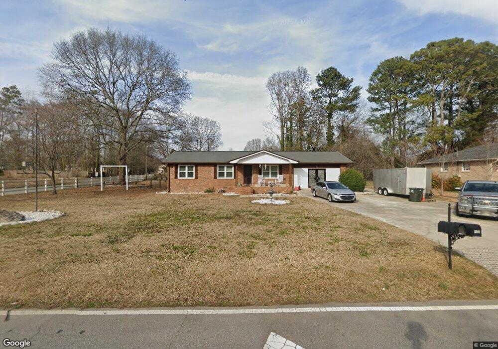
490 Vincent Dr Athens, GA 30607
Estimated Value: $212,871 - $321,000
--
Bed
--
Bath
1,674
Sq Ft
$166/Sq Ft
Est. Value
About This Home
This home is located at 490 Vincent Dr, Athens, GA 30607 and is currently estimated at $277,468, approximately $165 per square foot. 490 Vincent Dr is a home located in Clarke County with nearby schools including Burney-Harris-Lyons Middle School, Clarke Central High School, and Foothills Education Charter High School.
Ownership History
Date
Name
Owned For
Owner Type
Purchase Details
Closed on
Aug 28, 2000
Sold by
Butler Eddie J
Bought by
Williams Carlton
Current Estimated Value
Purchase Details
Closed on
May 25, 1999
Sold by
Coffey Cornelius E and Coffey Robin B
Bought by
Butler Eddie J
Purchase Details
Closed on
Sep 25, 1989
Sold by
Vickery Larry O
Bought by
Coffey Cornelius E and Coffey Robin B
Create a Home Valuation Report for This Property
The Home Valuation Report is an in-depth analysis detailing your home's value as well as a comparison with similar homes in the area
Home Values in the Area
Average Home Value in this Area
Purchase History
| Date | Buyer | Sale Price | Title Company |
|---|---|---|---|
| Williams Carlton | $87,900 | -- | |
| Butler Eddie J | $75,000 | -- | |
| Coffey Cornelius E | $55,900 | -- |
Source: Public Records
Tax History Compared to Growth
Tax History
| Year | Tax Paid | Tax Assessment Tax Assessment Total Assessment is a certain percentage of the fair market value that is determined by local assessors to be the total taxable value of land and additions on the property. | Land | Improvement |
|---|---|---|---|---|
| 2025 | $1,779 | $74,784 | $12,000 | $62,784 |
| 2024 | $1,779 | $70,804 | $12,000 | $58,804 |
| 2023 | $881 | $63,200 | $12,000 | $51,200 |
| 2022 | $1,317 | $51,280 | $10,400 | $40,880 |
| 2021 | $1,287 | $48,176 | $8,000 | $40,176 |
| 2020 | $1,185 | $45,150 | $8,000 | $37,150 |
| 2019 | $974 | $38,678 | $8,000 | $30,678 |
| 2018 | $681 | $30,044 | $8,000 | $22,044 |
| 2017 | $675 | $29,873 | $8,000 | $21,873 |
| 2016 | $575 | $26,950 | $8,000 | $18,950 |
| 2015 | $507 | $24,897 | $8,000 | $16,897 |
| 2014 | $515 | $25,103 | $8,000 | $17,103 |
Source: Public Records
Map
Nearby Homes
- 480 Vincent Dr
- 500 Vincent Dr
- 200 Harvest Way
- 204 Harvest Way
- 470 Vincent Dr
- 465 Vincent Dr
- 469 Vincent Dr
- 120 Harvest Way
- 208 Harvest Way
- 461 Vincent Dr
- 510 Vincent Dr
- 212 Harvest Way
- 460 Vincent Dr
- 116 Harvest Way
- 459 Vincent Dr
- 479 Vincent Dr
- 116 Winery Way Unit 1
- 200 Winery Way
- 216 Harvest Way
- 520 Vincent Dr