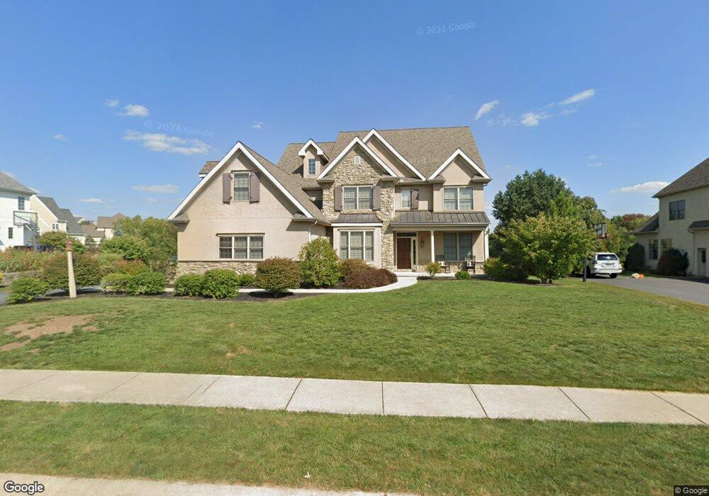
490 Wheatfield Dr Lititz, PA 17543
Kissel Hill NeighborhoodEstimated Value: $934,536 - $1,054,000
4
Beds
3
Baths
3,854
Sq Ft
$263/Sq Ft
Est. Value
About This Home
This home is located at 490 Wheatfield Dr, Lititz, PA 17543 and is currently estimated at $1,013,179, approximately $262 per square foot. 490 Wheatfield Dr is a home located in Lancaster County with nearby schools including Reidenbaugh Elementary School, Landis Run Intermediate School, and Manheim Township Middle School.
Ownership History
Date
Name
Owned For
Owner Type
Purchase Details
Closed on
Jul 13, 2005
Sold by
Hogan John and Herr Daryl D
Bought by
Sears Robert R and Sears Lisa L
Current Estimated Value
Home Financials for this Owner
Home Financials are based on the most recent Mortgage that was taken out on this home.
Original Mortgage
$300,000
Outstanding Balance
$143,380
Interest Rate
4.37%
Mortgage Type
Fannie Mae Freddie Mac
Estimated Equity
$869,799
Purchase Details
Closed on
Jun 13, 2003
Sold by
Snyder Road Partnership
Bought by
Sherman & Walton Inc
Create a Home Valuation Report for This Property
The Home Valuation Report is an in-depth analysis detailing your home's value as well as a comparison with similar homes in the area
Home Values in the Area
Average Home Value in this Area
Purchase History
| Date | Buyer | Sale Price | Title Company |
|---|---|---|---|
| Sears Robert R | $680,148 | -- | |
| Sherman & Walton Inc | $73,900 | -- |
Source: Public Records
Mortgage History
| Date | Status | Borrower | Loan Amount |
|---|---|---|---|
| Open | Sears Robert R | $300,000 |
Source: Public Records
Tax History
| Year | Tax Paid | Tax Assessment Tax Assessment Total Assessment is a certain percentage of the fair market value that is determined by local assessors to be the total taxable value of land and additions on the property. | Land | Improvement |
|---|---|---|---|---|
| 2025 | $12,353 | $570,900 | $123,100 | $447,800 |
| 2024 | $12,353 | $570,900 | $123,100 | $447,800 |
| 2023 | $11,828 | $570,900 | $123,100 | $447,800 |
| 2022 | $11,828 | $570,900 | $123,100 | $447,800 |
| 2021 | $11,564 | $570,900 | $123,100 | $447,800 |
| 2020 | $11,564 | $570,900 | $123,100 | $447,800 |
| 2019 | $11,452 | $570,900 | $123,100 | $447,800 |
| 2018 | $8,520 | $570,900 | $123,100 | $447,800 |
| 2017 | $12,367 | $486,000 | $110,500 | $375,500 |
| 2016 | $12,366 | $486,000 | $110,500 | $375,500 |
| 2015 | $3,108 | $486,000 | $110,500 | $375,500 |
| 2014 | $8,951 | $486,000 | $110,500 | $375,500 |
Source: Public Records
Map
Nearby Homes
- 649 Dorset St
- 628 Dorset St
- 1221 Brighton Ave
- 297 Sarsen Dr
- 505 Northampton Dr Unit 2
- 504 Cheltenham Ct
- 421 Southampton Dr
- 512 Northampton Dr Unit 43
- 701 Woodfield Dr
- LOT 12 Bent Creek Dr
- 660 Woodfield Dr
- 1098 Stillwood Cir
- LOT 34 Honey Farm Rd
- LOT 35 Honey Farm Rd
- 168 Olde Field Dr
- 634 Northfield Rd
- 50 Meadowbreeze
- #48 Meadowbreeze Ln
- 616 Petersburg Rd
- 393 Fern Ln Unit 8
- 486 Wheatfield Dr
- 494 Wheatfield Dr
- 482 Wheatfield Dr
- 493 Wheatfield Dr
- 493 Wheatfield Dr Unit 37
- 498 Wheatfield Dr
- 497 Wheatfield Dr
- 489 Wheatfield Dr
- 485 Wheatfield Dr
- 508 Dorset St
- 1508 Wheatfield Dr
- 0 Wheatfield Dr
- 512 Dorset St
- 502 Wheatfield Dr
- 676 Dorset St
- 481 Wheatfield Dr
- 504 Dorset St
- 681 Dorset St
- 506 Wheatfield Dr
- 600 Dorset St