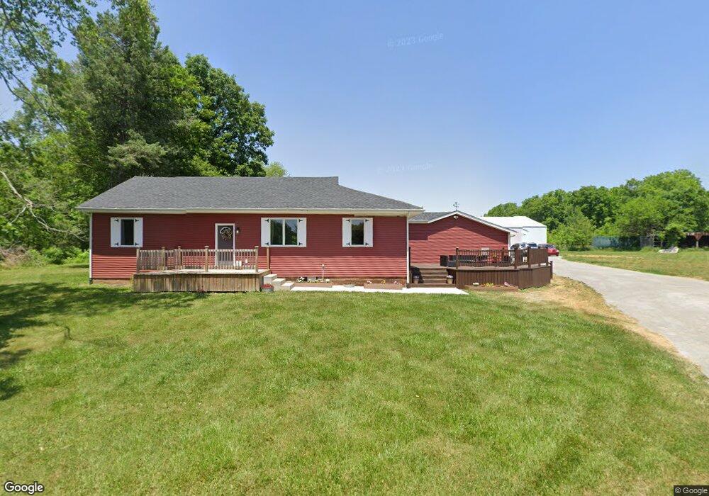
4900 W 650 N Thorntown, IN 46071
Estimated Value: $464,000 - $528,000
3
Beds
3
Baths
2,814
Sq Ft
$175/Sq Ft
Est. Value
About This Home
This home is located at 4900 W 650 N, Thorntown, IN 46071 and is currently estimated at $491,826, approximately $174 per square foot. 4900 W 650 N is a home located in Boone County with nearby schools including Western Boone Junior/Senior High School.
Ownership History
Date
Name
Owned For
Owner Type
Purchase Details
Closed on
Jul 27, 2021
Sold by
Way Collin W
Bought by
Geyer Eric and Geyer April
Current Estimated Value
Home Financials for this Owner
Home Financials are based on the most recent Mortgage that was taken out on this home.
Original Mortgage
$354,000
Outstanding Balance
$321,689
Interest Rate
3%
Mortgage Type
VA
Estimated Equity
$170,137
Purchase Details
Closed on
Apr 5, 2016
Sold by
Hester Andrea Lynn and Asbury John D
Bought by
Way Collin M
Purchase Details
Closed on
Mar 24, 2005
Sold by
Asbury Beula M
Bought by
Asbury R John
Home Financials for this Owner
Home Financials are based on the most recent Mortgage that was taken out on this home.
Original Mortgage
$57,787
Interest Rate
6.13%
Mortgage Type
VA
Create a Home Valuation Report for This Property
The Home Valuation Report is an in-depth analysis detailing your home's value as well as a comparison with similar homes in the area
Home Values in the Area
Average Home Value in this Area
Purchase History
| Date | Buyer | Sale Price | Title Company |
|---|---|---|---|
| Geyer Eric | $354,000 | Boston National Title | |
| Way Collin M | -- | Meridian Title | |
| Asbury R John | -- | -- |
Source: Public Records
Mortgage History
| Date | Status | Borrower | Loan Amount |
|---|---|---|---|
| Open | Geyer Eric | $354,000 | |
| Previous Owner | Asbury R John | $57,787 |
Source: Public Records
Tax History Compared to Growth
Tax History
| Year | Tax Paid | Tax Assessment Tax Assessment Total Assessment is a certain percentage of the fair market value that is determined by local assessors to be the total taxable value of land and additions on the property. | Land | Improvement |
|---|---|---|---|---|
| 2025 | $2,255 | $411,200 | $43,700 | $367,500 |
| 2024 | $2,255 | $382,100 | $43,700 | $338,400 |
| 2023 | $2,291 | $360,500 | $43,700 | $316,800 |
| 2022 | $4,222 | $338,600 | $43,700 | $294,900 |
| 2021 | $2,322 | $290,400 | $43,700 | $246,700 |
| 2020 | $2,234 | $280,300 | $43,700 | $236,600 |
| 2019 | $978 | $139,500 | $43,700 | $95,800 |
| 2018 | $1,365 | $188,300 | $43,700 | $144,600 |
| 2017 | $1,327 | $188,000 | $43,700 | $144,300 |
| 2016 | $1,224 | $177,000 | $43,700 | $133,300 |
| 2014 | $1,102 | $173,400 | $43,700 | $129,700 |
| 2013 | $1,059 | $157,900 | $30,400 | $127,500 |
Source: Public Records
Map
Nearby Homes
- 5571 W 700 N
- 6823 N US Highway 52
- 5593 W 700 N
- 5779 W State Road 47
- 6519 N 350 W
- 6433 W State Road 47
- 6691 Indiana 47
- 328 N Front St
- 4535 N Us Hwy 52
- 117 N Market St
- 5000 N 275 W
- 3502 W 450 N
- 223 S West St
- 1321 Locust Place
- 1323 Locust Place
- 5388 W Hazelrigg Rd
- Ironwood Plan at Northwood Haven
- Spruce Plan at Northwood Haven
- Ashton Plan at Northwood Haven
- Palmetto Plan at Northwood Haven