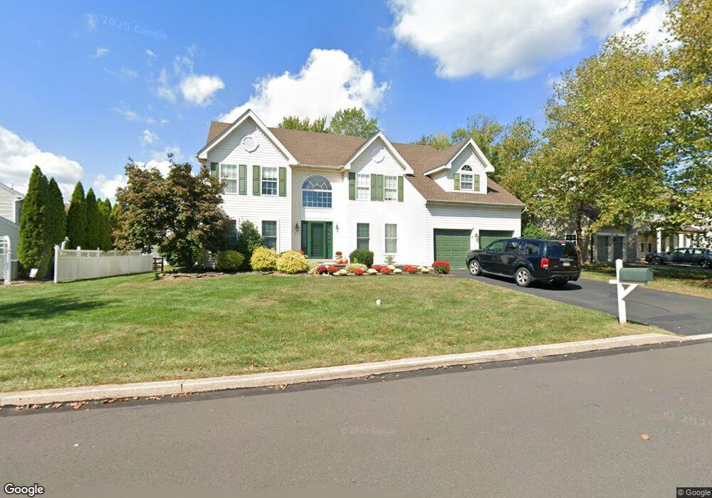
4902 Crosspoint Dr Doylestown, PA 18902
Estimated Value: $867,566 - $935,000
4
Beds
3
Baths
3,300
Sq Ft
$271/Sq Ft
Est. Value
About This Home
This home is located at 4902 Crosspoint Dr, Doylestown, PA 18902 and is currently estimated at $894,142, approximately $270 per square foot. 4902 Crosspoint Dr is a home located in Bucks County with nearby schools including Cold Spring Elementary School, Holicong Middle School, and Central Bucks High School - East.
Ownership History
Date
Name
Owned For
Owner Type
Purchase Details
Closed on
Aug 17, 1998
Sold by
Gira Barron M and Gira Kathleen M
Bought by
Crabbe James S and Crabbe Virginia C
Current Estimated Value
Home Financials for this Owner
Home Financials are based on the most recent Mortgage that was taken out on this home.
Original Mortgage
$209,600
Interest Rate
6.9%
Purchase Details
Closed on
Aug 27, 1996
Sold by
Barnside Development Co Ltd Prtnrshp
Bought by
Gira Barron M and Gira Kathleen M
Home Financials for this Owner
Home Financials are based on the most recent Mortgage that was taken out on this home.
Original Mortgage
$202,000
Interest Rate
8.11%
Create a Home Valuation Report for This Property
The Home Valuation Report is an in-depth analysis detailing your home's value as well as a comparison with similar homes in the area
Home Values in the Area
Average Home Value in this Area
Purchase History
| Date | Buyer | Sale Price | Title Company |
|---|---|---|---|
| Crabbe James S | $262,000 | -- | |
| Gira Barron M | $224,900 | -- |
Source: Public Records
Mortgage History
| Date | Status | Borrower | Loan Amount |
|---|---|---|---|
| Previous Owner | Crabbe James S | $209,600 | |
| Previous Owner | Gira Barron M | $202,000 |
Source: Public Records
Tax History Compared to Growth
Tax History
| Year | Tax Paid | Tax Assessment Tax Assessment Total Assessment is a certain percentage of the fair market value that is determined by local assessors to be the total taxable value of land and additions on the property. | Land | Improvement |
|---|---|---|---|---|
| 2025 | $7,346 | $47,090 | $9,960 | $37,130 |
| 2024 | $7,346 | $45,120 | $9,960 | $35,160 |
| 2023 | $7,097 | $45,120 | $9,960 | $35,160 |
| 2022 | $7,012 | $45,120 | $9,960 | $35,160 |
| 2021 | $6,928 | $45,120 | $9,960 | $35,160 |
| 2020 | $6,928 | $45,120 | $9,960 | $35,160 |
| 2019 | $6,883 | $45,120 | $9,960 | $35,160 |
| 2018 | $6,883 | $45,120 | $9,960 | $35,160 |
| 2017 | $6,827 | $45,120 | $9,960 | $35,160 |
| 2016 | $6,894 | $45,120 | $9,960 | $35,160 |
| 2015 | -- | $45,120 | $9,960 | $35,160 |
| 2014 | -- | $45,120 | $9,960 | $35,160 |
Source: Public Records
Map
Nearby Homes
- 3689 Hancock Ln
- 5063 Sagewood Ct
- 5115 Sugar Hill Ct
- 3479 Durham Rd
- 3455 Durham Rd
- 4928 Edgewood Rd
- 3975 Amberton Ct
- 3468 Holicong Rd
- 4605 Twinbrook Cir
- 4936 Davis Dr
- 5281 Harrington Ct
- 4925 Redfield Rd
- 3865 Burnt House Hill Rd
- 4542 Deep Creek Way
- 4250 Aly Dr
- 4871 E Blossom Dr
- 5110 Harmony Ct W
- 5491 Long Ln
- 3555 Northview Ln
- 4201 Sir Andrew Cir
- 4910 Crosspoint Dr
- 4898 Crosspoint Dr
- 3747 E Brandon Way
- 4916 Crosspoint Dr
- 3706 Seneca Ct
- 4901 Crosspoint Dr
- 3755 E Brandon Way
- 4924 Crosspoint Dr
- 3696 Seneca Ct
- 3734 E Brandon Way
- 3705 Seneca Ct
- 3763 E Brandon Way
- 3711 E Brandon Way
- 4930 Crosspoint Dr
- 3724 E Brandon Way
- 3711 Seneca Ct
- 3695 Seneca Ct
- 3690 Seneca Ct
- 4868 Winterson Ct
- 3769 E Brandon Way