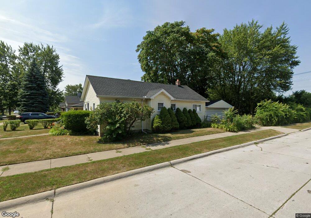
4902 Westpoint St Dearborn Heights, MI 48125
Estimated Value: $141,000 - $150,000
2
Beds
1
Bath
932
Sq Ft
$156/Sq Ft
Est. Value
About This Home
This home is located at 4902 Westpoint St, Dearborn Heights, MI 48125 and is currently estimated at $145,355, approximately $155 per square foot. 4902 Westpoint St is a home located in Wayne County with nearby schools including Polk Elementary School, Bedford School, and Pardee School.
Ownership History
Date
Name
Owned For
Owner Type
Purchase Details
Closed on
Jul 7, 2009
Sold by
Donovan Shaun
Bought by
Hayden William Francis
Current Estimated Value
Purchase Details
Closed on
Jan 22, 2009
Sold by
Midfirst Bank
Bought by
The Secretary Of Housing & Urban Develop
Purchase Details
Closed on
Jul 16, 2008
Sold by
Dace Irene
Bought by
Midfirst Bank
Purchase Details
Closed on
Jan 19, 2005
Sold by
Haskell Debra C and Cortes Gilberto
Bought by
Dace Irene
Home Financials for this Owner
Home Financials are based on the most recent Mortgage that was taken out on this home.
Original Mortgage
$90,578
Interest Rate
5.79%
Mortgage Type
FHA
Create a Home Valuation Report for This Property
The Home Valuation Report is an in-depth analysis detailing your home's value as well as a comparison with similar homes in the area
Home Values in the Area
Average Home Value in this Area
Purchase History
| Date | Buyer | Sale Price | Title Company |
|---|---|---|---|
| Hayden William Francis | $18,000 | None Available | |
| The Secretary Of Housing & Urban Develop | -- | None Available | |
| Midfirst Bank | $98,573 | None Available | |
| Dace Irene | $92,000 | Downriver Title Agency |
Source: Public Records
Mortgage History
| Date | Status | Borrower | Loan Amount |
|---|---|---|---|
| Previous Owner | Dace Irene | $90,578 |
Source: Public Records
Tax History Compared to Growth
Tax History
| Year | Tax Paid | Tax Assessment Tax Assessment Total Assessment is a certain percentage of the fair market value that is determined by local assessors to be the total taxable value of land and additions on the property. | Land | Improvement |
|---|---|---|---|---|
| 2025 | $1,584 | $65,200 | $0 | $0 |
| 2024 | $1,584 | $58,200 | $0 | $0 |
| 2023 | $1,649 | $50,100 | $0 | $0 |
| 2022 | $2,109 | $43,900 | $0 | $0 |
| 2021 | $2,169 | $39,800 | $0 | $0 |
| 2019 | $2,020 | $32,800 | $0 | $0 |
| 2018 | $1,652 | $27,300 | $0 | $0 |
| 2017 | $796 | $25,100 | $0 | $0 |
| 2016 | $1,578 | $23,900 | $0 | $0 |
| 2015 | $2,220 | $22,200 | $0 | $0 |
| 2013 | $2,300 | $23,800 | $0 | $0 |
| 2010 | -- | $29,000 | $0 | $0 |
Source: Public Records
Map
Nearby Homes
- 4901 Cornell St
- 4665 Syracuse St
- 24117 Eton Ave
- 24035 Currier St
- 4489 Westpoint St
- 4506 Syracuse St
- 4474 Syracuse St
- 5689 Cornell St
- 5671 Syracuse St
- 24339 Eton Ave
- 24360 Pennie St
- 4193 Cornell St
- 4449 Academy St
- 24443 Powers Ave
- 23214 S Brookside Dr
- 5908 Pine St
- 24426 Lehigh St
- 4459 Parker St
- 24409 Stanford St
- 5954 Pine St
- 4910 Westpoint St
- 4918 Westpoint St
- 4928 Westpoint St
- 4706 Westpoint St
- 4936 Westpoint St
- 4698 Westpoint St
- 4944 Westpoint St
- 4903 Westpoint St
- 4843 S Telegraph Rd
- 4929 S Telegraph Rd
- 4690 Westpoint St
- 4715 Westpoint St
- 4927 Westpoint St
- 4970 Westpoint St
- 4682 Westpoint St
- 4699 Westpoint St
- 4996 Westpoint St
- 4945 Westpoint St
- 4691 Westpoint St
- 0 Pennie St