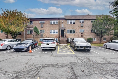
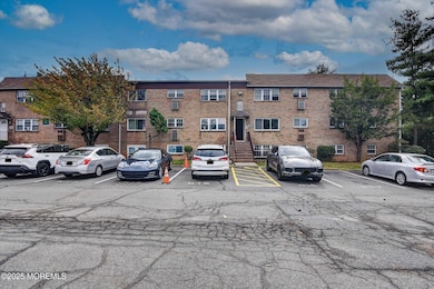
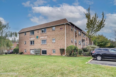
491 College Dr Unit 491 Edison, NJ 08817
Estimated payment $2,444/month
Highlights
- Very Popular Property
- Basketball Court
- End Unit
- Benjamin Franklin Elementary School Rated A-
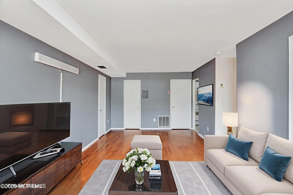
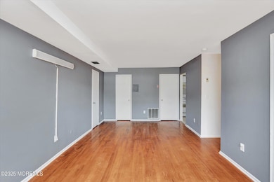
- Wood Flooring
- Eat-In Kitchen
About This Home
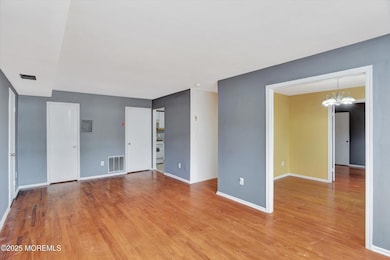
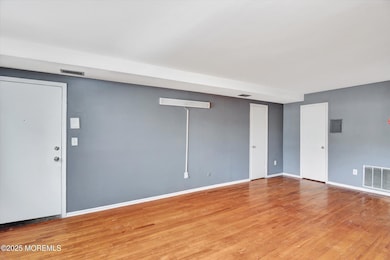
Welcome to this bright and inviting FIRST-fl. (not ground fl.) end unit, offering the perfect combination of comfort and convenience. This beautifully maintained 3-bedroom, 2-bath home features gleaming hardwood floors throughout and large windows that flood the space with natural light. Enjoy a spacious and open layout with a generous living room, dedicated dining area, and an EI kitchenideal for both everyday living and entertaining. The freshly painted interior (2025) and newer hot water heater (2024) make this home move-in ready. The primary suite offers privacy and comfort with its own full bath and ample closet space. Additional highlights include plenty of storage, assigned parking, and a low HOA fee that covers water, sewer, trash, snow removal, and exterior maintenance. With improved property management, low taxes, and a commuter-friendly location near Middlesex College, shopping, major highways, and bus #813, this home checks all the boxes. New owner required to reside 2 yr before RENTING. Cash & Conv loans ONLY!
Listing Agent
Keller Williams Realty West Monmouth License #1650219 Listed on: 10/22/2025

Property Details
Home Type
- Condominium
Est. Annual Taxes
- $5,060
Year Built
- Built in 1977
HOA Fees
- $442 Monthly HOA Fees
Home Design
- Brick Exterior Construction
- Shingle Roof
Interior Spaces
- 1,188 Sq Ft Home
- 1-Story Property
Kitchen
- Eat-In Kitchen
- Gas Cooktop
- Dishwasher
Flooring
- Wood
- Ceramic Tile
Bedrooms and Bathrooms
- 3 Bedrooms
- 2 Full Bathrooms
- Primary Bathroom includes a Walk-In Shower
Parking
- 1 Parking Space
- No Garage
- Common or Shared Parking
- Assigned Parking
Schools
- Edison High School
Utilities
- No Cooling
- Forced Air Heating System
- Natural Gas Water Heater
Additional Features
- Basketball Court
- End Unit
Listing and Financial Details
- Assessor Parcel Number 05-00375-32-00025-0000-C0491
Community Details
Overview
- Front Yard Maintenance
- Association fees include trash, lawn maintenance, mgmt fees, sewer, snow removal, water
- Millpointe Subdivision
Recreation
- Snow Removal
Map
Home Values in the Area
Average Home Value in this Area
Tax History
| Year | Tax Paid | Tax Assessment Tax Assessment Total Assessment is a certain percentage of the fair market value that is determined by local assessors to be the total taxable value of land and additions on the property. | Land | Improvement |
|---|---|---|---|---|
| 2025 | $5,060 | $85,000 | $40,000 | $45,000 |
| 2024 | $5,033 | $85,000 | $40,000 | $45,000 |
| 2023 | $5,033 | $85,000 | $40,000 | $45,000 |
| 2022 | $4,798 | $81,000 | $40,000 | $41,000 |
| 2021 | $4,603 | $81,000 | $40,000 | $41,000 |
| 2020 | $4,738 | $81,000 | $40,000 | $41,000 |
| 2019 | $4,291 | $81,000 | $40,000 | $41,000 |
| 2018 | $4,213 | $81,000 | $40,000 | $41,000 |
| 2017 | $4,172 | $81,000 | $40,000 | $41,000 |
| 2016 | $4,095 | $81,000 | $40,000 | $41,000 |
| 2015 | $3,940 | $81,000 | $40,000 | $41,000 |
| 2014 | $3,828 | $81,000 | $40,000 | $41,000 |
Property History
| Date | Event | Price | List to Sale | Price per Sq Ft |
|---|---|---|---|---|
| 11/11/2025 11/11/25 | Price Changed | $300,000 | -3.2% | $253 / Sq Ft |
| 10/22/2025 10/22/25 | For Sale | $310,000 | -- | $261 / Sq Ft |
Purchase History
| Date | Type | Sale Price | Title Company |
|---|---|---|---|
| Deed | $172,500 | Simplicity Title Llc | |
| Bargain Sale Deed | $210,000 | None Available |
Mortgage History
| Date | Status | Loan Amount | Loan Type |
|---|---|---|---|
| Open | $129,000 | New Conventional | |
| Previous Owner | $150,000 | Purchase Money Mortgage |
Source: MOREMLS (Monmouth Ocean Regional REALTORS®)
MLS Number: 22532044
APN: 05-00375-32-00025-0000-C0491
Disclaimer: Certain information contained herein is derived from information provided by parties other than Homes.com. All information provided is deemed reliable, but is not guaranteed to be accurate and should be independently verified.
![]() IDX information is provided exclusively for personal, non-commercial use, and may not be used for any purpose other than to identify prospective properties consumers may be interested in purchasing.
IDX information is provided exclusively for personal, non-commercial use, and may not be used for any purpose other than to identify prospective properties consumers may be interested in purchasing.
Information is deemed reliable but not guaranteed.
- 190 College Dr
- 15 College Dr Unit 15
- 23 College Dr Unit 23
- 14 College Dr
- 203 College Dr
- 106 College Dr
- 2505 Woodbridge Ave Unit 26L
- 2505 Woodbridge Ave Unit 9 L
- 2505 Woodbridge Ave Unit 19L
- 22 Trenton Ave
- 7 Candy Ct
- 1 Laurie Ln
- 2 Laurie Ln
- 7 Laurie Ln
- 9 Laurie Ln
- 6 Laurie Ln
- 5 Meyer Rd
- 14 Roger Rd
- 11 Marie Ln
- 27 Mill Rd
- 215 College Dr
- 71 College Dr
- 99 College Dr
- 420 College Dr Unit 420
- 0 College Dr Unit NJMX2010898
- 97 Horizon Dr
- 601 Horizon Dr
- 30 Brookside Rd
- 27 Mill Rd
- 238 Old Post Rd
- 2221 Edward Stec Blvd
- 2336 Edward Stec Blvd Unit 2336
- 340 Old Post Rd
- 28 Woodedge Ave Unit 2802
- 32 Woodedge Ave
- 38 Woodedge Ave
- 10 Hector Ave
- 1000 Us Highway 1
- 17 Jill Ct Unit 19
- 19 Jill Ct