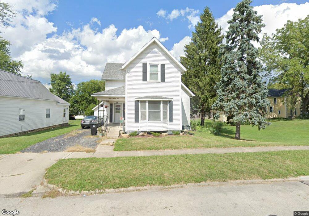
491 Douglas St Wilmington, OH 45177
Estimated Value: $161,691 - $180,000
3
Beds
1
Bath
1,185
Sq Ft
$143/Sq Ft
Est. Value
About This Home
This home is located at 491 Douglas St, Wilmington, OH 45177 and is currently estimated at $169,673, approximately $143 per square foot. 491 Douglas St is a home located in Clinton County with nearby schools including Wilmington High School, Arcadia Learning Commons, and Wilmington Christian Academy.
Ownership History
Date
Name
Owned For
Owner Type
Purchase Details
Closed on
Jul 1, 2021
Sold by
Snarr D Neil D and Snarr Ruth E
Bought by
Snarr Isaiah C and Snarr Michael T
Current Estimated Value
Home Financials for this Owner
Home Financials are based on the most recent Mortgage that was taken out on this home.
Original Mortgage
$90,000
Outstanding Balance
$81,661
Interest Rate
2.9%
Mortgage Type
Commercial
Estimated Equity
$88,012
Purchase Details
Closed on
Aug 20, 2019
Sold by
Snarr D Neil and Snarr Ruth E
Bought by
Snarr D Neil and Snarr Ruth E
Purchase Details
Closed on
Dec 13, 2010
Sold by
Household Realty Corporation
Bought by
Snarr D Neil and Snarr Ruth E
Purchase Details
Closed on
May 14, 2010
Sold by
Ralph D Fizer Sr Sheriff Of Clinton Cou
Bought by
Household Realty Corp
Purchase Details
Closed on
Jan 1, 1990
Bought by
Plotner Joel D
Create a Home Valuation Report for This Property
The Home Valuation Report is an in-depth analysis detailing your home's value as well as a comparison with similar homes in the area
Home Values in the Area
Average Home Value in this Area
Purchase History
| Date | Buyer | Sale Price | Title Company |
|---|---|---|---|
| Snarr Isaiah C | $333 | None Listed On Document | |
| Snarr Isaiah C | $100,000 | None Available | |
| Snarr D Neil | -- | None Available | |
| Snarr D Neil | -- | Frank P Dee Attorney At Law | |
| Household Realty Corp | -- | -- | |
| Plotner Joel D | -- | -- |
Source: Public Records
Mortgage History
| Date | Status | Borrower | Loan Amount |
|---|---|---|---|
| Open | Snarr Isaiah C | $90,000 | |
| Closed | Snarr Isaiah C | $90,000 |
Source: Public Records
Tax History Compared to Growth
Tax History
| Year | Tax Paid | Tax Assessment Tax Assessment Total Assessment is a certain percentage of the fair market value that is determined by local assessors to be the total taxable value of land and additions on the property. | Land | Improvement |
|---|---|---|---|---|
| 2024 | $1,129 | $32,770 | $4,520 | $28,250 |
| 2023 | $1,129 | $32,770 | $4,520 | $28,250 |
| 2022 | $952 | $26,000 | $4,100 | $21,900 |
| 2021 | $951 | $25,650 | $4,100 | $21,550 |
| 2020 | $894 | $25,650 | $4,100 | $21,550 |
| 2019 | $720 | $18,870 | $4,100 | $14,770 |
| 2018 | $727 | $18,870 | $4,100 | $14,770 |
| 2017 | $707 | $18,870 | $4,100 | $14,770 |
| 2016 | $709 | $18,690 | $4,060 | $14,630 |
| 2015 | $698 | $18,690 | $4,060 | $14,630 |
| 2013 | $706 | $18,690 | $4,060 | $14,630 |
Source: Public Records
Map
Nearby Homes
- 0 Prairie Rd Unit 1835070
- 1053 Main St
- 0 Antioch Rd Unit 891198
- 272 S Walnut St
- 62 Applegate St
- 454 Belmont Ave
- 338 S Walnut St
- 289 S Walnut St
- 0 St Rt 134 Unit 1607133
- 0 S Us Rt 68 Unit 1527315
- 354 Darbyshire Dr
- 0 Rombach Ave Unit 1846041
- 1046 Fife Ave
- 1.458 AC Prairie Ave
- 326 N Walnut St
- 442 High St
- 600 Kathryn Dr
- 149 W Truesdell St
- 440 N Walnut St
- 71 W Short St