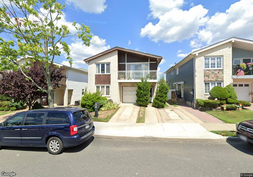
491 Klondike Ave Staten Island, NY 10314
New Springville NeighborhoodEstimated Value: $999,000 - $1,194,000
6
Beds
4
Baths
3,012
Sq Ft
$376/Sq Ft
Est. Value
About This Home
This home is located at 491 Klondike Ave, Staten Island, NY 10314 and is currently estimated at $1,131,251, approximately $375 per square foot. 491 Klondike Ave is a home located in Richmond County with nearby schools including P.S. 69 - Daniel D. Tompkins, Is 72 Rocco Laurie, and Susan E Wagner High School.
Ownership History
Date
Name
Owned For
Owner Type
Purchase Details
Closed on
May 27, 2010
Sold by
Alhadeff Reuben
Bought by
Mai Wei Dong and Li Yan Yun
Current Estimated Value
Home Financials for this Owner
Home Financials are based on the most recent Mortgage that was taken out on this home.
Original Mortgage
$430,000
Outstanding Balance
$290,159
Interest Rate
5.11%
Mortgage Type
New Conventional
Estimated Equity
$841,092
Purchase Details
Closed on
Sep 23, 2008
Sold by
Alhadeff Reuben and Alhadeff Vicki G
Bought by
Alhadeff Reuben
Create a Home Valuation Report for This Property
The Home Valuation Report is an in-depth analysis detailing your home's value as well as a comparison with similar homes in the area
Home Values in the Area
Average Home Value in this Area
Purchase History
| Date | Buyer | Sale Price | Title Company |
|---|---|---|---|
| Mai Wei Dong | $630,000 | New Jersey Title Ins Company | |
| Alhadeff Reuben | -- | Commonwealth Land Title Insu |
Source: Public Records
Mortgage History
| Date | Status | Borrower | Loan Amount |
|---|---|---|---|
| Open | Mai Wei Dong | $430,000 |
Source: Public Records
Tax History Compared to Growth
Tax History
| Year | Tax Paid | Tax Assessment Tax Assessment Total Assessment is a certain percentage of the fair market value that is determined by local assessors to be the total taxable value of land and additions on the property. | Land | Improvement |
|---|---|---|---|---|
| 2025 | $9,555 | $77,100 | $8,712 | $68,388 |
| 2024 | $9,555 | $65,100 | $9,734 | $55,366 |
| 2023 | $9,662 | $47,574 | $9,305 | $38,269 |
| 2022 | $9,425 | $62,640 | $13,320 | $49,320 |
| 2021 | $9,374 | $51,840 | $13,320 | $38,520 |
| 2020 | $10,249 | $46,320 | $13,320 | $33,000 |
| 2019 | $8,293 | $49,380 | $13,320 | $36,060 |
| 2018 | $8,082 | $39,645 | $11,415 | $28,230 |
| 2017 | $8,020 | $39,345 | $12,604 | $26,741 |
| 2016 | $7,420 | $37,119 | $12,736 | $24,383 |
| 2015 | $6,340 | $35,019 | $9,713 | $25,306 |
| 2014 | $6,340 | $33,038 | $10,993 | $22,045 |
Source: Public Records
Map
Nearby Homes
- 507 Klondike Ave
- 44 McVeigh Ave
- 343 Travis Ave
- 86 Evans St
- 41 Furness Place
- 101 McVeigh Ave
- 107 Denker Place
- 72 Bangor St
- 22 Braisted Ave
- 23 Bangor St
- 45 Braisted Ave
- 9 Furness Place
- 110 Lewiston St
- 81 Fraser St
- 611 Klondike Ave
- 186 Monahan Ave
- 190 Monahan Ave
- 60 Copley St
- 143 Monahan Ave
- 4 Bangor St
- 487 Klondike Ave
- 495 Klondike Ave
- 483 Klondike Ave
- 499 Klondike Ave
- 477 Klondike Ave
- 503 Klondike Ave
- 284 Travis Ave
- 288 Travis Ave
- 282 Travis Ave
- 290 Travis Ave
- 280 Travis Ave
- 292 Travis Ave
- 473 Klondike Ave
- 278 Travis Ave
- 294 Travis Ave
- 276 Travis Ave
- 480 Klondike Ave
- 484 Klondike Ave
- 298 Travis Ave
- 476 Klondike Ave