Estimated Value: $500,391 - $568,000
2
Beds
2
Baths
1,824
Sq Ft
$300/Sq Ft
Est. Value
About This Home
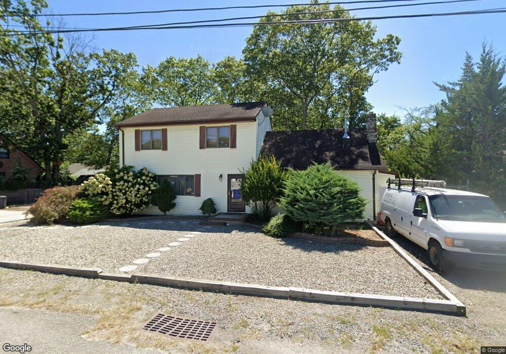
This home is located at 491 W Briarcliff Dr, Brick, NJ 08723 and is currently estimated at $548,098, approximately $300 per square foot. 491 W Briarcliff Dr is a home located in Ocean County with nearby schools including Emma Havens Young Elementary School, Lake Riviera Middle School, and Brick Township High School.
Ownership History
Date
Name
Owned For
Owner Type
Purchase Details
Closed on
Apr 23, 2021
Sold by
Kebeck Edmond
Bought by
Kebeck Darren A
Current Estimated Value
Home Financials for this Owner
Home Financials are based on the most recent Mortgage that was taken out on this home.
Original Mortgage
$270,000
Outstanding Balance
$244,167
Interest Rate
3.1%
Mortgage Type
New Conventional
Estimated Equity
$303,931
Create a Home Valuation Report for This Property
The Home Valuation Report is an in-depth analysis detailing your home's value as well as a comparison with similar homes in the area
Home Values in the Area
Average Home Value in this Area
Purchase History
| Date | Buyer | Sale Price | Title Company |
|---|---|---|---|
| Kebeck Darren A | $357,500 | Foundation Title Llc | |
| Kebeck Darren A | $337,500 | Foundation Title |
Source: Public Records
Mortgage History
| Date | Status | Borrower | Loan Amount |
|---|---|---|---|
| Open | Kebeck Darren A | $270,000 | |
| Closed | Kebeck Darren A | $270,000 |
Source: Public Records
Tax History
| Year | Tax Paid | Tax Assessment Tax Assessment Total Assessment is a certain percentage of the fair market value that is determined by local assessors to be the total taxable value of land and additions on the property. | Land | Improvement |
|---|---|---|---|---|
| 2025 | $7,018 | $258,600 | $141,100 | $117,500 |
| 2024 | $6,349 | $258,600 | $141,100 | $117,500 |
| 2023 | $6,266 | $258,600 | $141,100 | $117,500 |
| 2022 | $6,266 | $258,600 | $141,100 | $117,500 |
| 2021 | $6,134 | $258,600 | $141,100 | $117,500 |
| 2020 | $6,056 | $258,600 | $141,100 | $117,500 |
| 2019 | $5,956 | $258,600 | $141,100 | $117,500 |
| 2018 | $5,819 | $258,600 | $141,100 | $117,500 |
| 2017 | $5,661 | $258,600 | $141,100 | $117,500 |
| 2016 | $5,632 | $258,600 | $141,100 | $117,500 |
| 2015 | $5,485 | $258,600 | $141,100 | $117,500 |
| 2014 | $5,441 | $258,600 | $141,100 | $117,500 |
Source: Public Records
Map
Nearby Homes
- 488 Mohawk Dr
- 0 Mantoloking Rd Unit East of 113 crosses
- 477 Mantoloking Rd
- 478 Mantoloking Rd
- 484 Bara St
- 471 Woodpark Dr
- 511 Pinecroft Dr
- 521 Dorothy Place
- 507 Adamston Rd
- 439 Adamston Rd
- 56 Tall Timber Dr
- 421 Malibu Way
- 61 Reservation Row
- 9 Bayberry Ave
- 53 Country Club Ct
- 00 Mantoloking Rd
- 33 Wintergreen Ave
- 353 Church Rd
- 593 Leanora St
- 592 Kingfisher Cir
- 493 W Briarcliff Dr
- 492 Mohawk Dr
- 485 W Briarcliff Dr
- 484 Mohawk Dr
- 489 Mantoloking Rd
- 496 Mohawk Dr
- 491 Mantoloking Rd
- 495 W Briarcliff Dr
- 487 Mantoloking Rd
- 495 Mantoloking Rd
- 500 Mohawk Dr
- 487 Mohawk Dr
- 497 Mantoloking Rd
- 483 Mantoloking Rd
- 491 Mohawk Dr
- 485 Mohawk Dr
- 480 Mohawk Dr
- 0 Mantoloking Rd Unit 11584872
- 0 Mantoloking Rd Unit 22514308
- 0 Mantoloking Rd Unit 22506750
Your Personal Tour Guide
Ask me questions while you tour the home.