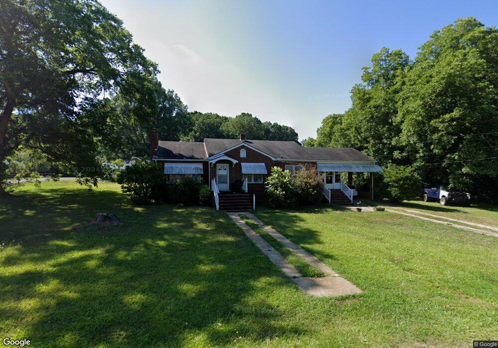
491 York St Ramseur, NC 27316
Estimated Value: $190,322 - $245,000
--
Bed
1
Bath
1,480
Sq Ft
$152/Sq Ft
Est. Value
About This Home
This home is located at 491 York St, Ramseur, NC 27316 and is currently estimated at $225,081, approximately $152 per square foot. 491 York St is a home located in Randolph County with nearby schools including Ramseur Elementary School, Southeastern Randolph Middle School, and Eastern Randolph High School.
Ownership History
Date
Name
Owned For
Owner Type
Purchase Details
Closed on
Dec 17, 2018
Sold by
Mcneil Eddie Howard and Estate Of Henrietta W Mcneil
Bought by
Davidson And Norris Rentals Llc
Current Estimated Value
Purchase Details
Closed on
Jul 18, 2018
Sold by
Marshall R Cox
Bought by
Hernandez Chelsey and Hicks Kenneth
Home Financials for this Owner
Home Financials are based on the most recent Mortgage that was taken out on this home.
Original Mortgage
$127,636
Interest Rate
4.53%
Create a Home Valuation Report for This Property
The Home Valuation Report is an in-depth analysis detailing your home's value as well as a comparison with similar homes in the area
Home Values in the Area
Average Home Value in this Area
Purchase History
| Date | Buyer | Sale Price | Title Company |
|---|---|---|---|
| Davidson And Norris Rentals Llc | $87,000 | None Available | |
| Hernandez Chelsey | -- | -- |
Source: Public Records
Mortgage History
| Date | Status | Borrower | Loan Amount |
|---|---|---|---|
| Previous Owner | Hernandez Chelsey | $127,636 | |
| Previous Owner | Hernandez Chelsey | -- |
Source: Public Records
Tax History Compared to Growth
Tax History
| Year | Tax Paid | Tax Assessment Tax Assessment Total Assessment is a certain percentage of the fair market value that is determined by local assessors to be the total taxable value of land and additions on the property. | Land | Improvement |
|---|---|---|---|---|
| 2025 | $1,866 | $152,950 | $28,320 | $124,630 |
| 2024 | $1,866 | $152,950 | $28,320 | $124,630 |
| 2023 | $1,790 | $152,950 | $28,320 | $124,630 |
| 2022 | $1,401 | $107,540 | $21,850 | $85,690 |
| 2021 | $1,401 | $107,540 | $21,850 | $85,690 |
| 2020 | $1,401 | $107,540 | $21,850 | $85,690 |
| 2019 | $1,401 | $107,540 | $21,850 | $85,690 |
| 2018 | $1,208 | $91,340 | $14,480 | $76,860 |
| 2016 | $1,208 | $91,344 | $14,480 | $76,864 |
| 2015 | $1,210 | $91,344 | $14,480 | $76,864 |
| 2014 | -- | $91,344 | $14,480 | $76,864 |
Source: Public Records
Map
Nearby Homes
- 545 Coleridge Rd
- 715 Liberty St
- 321 Coleridge Rd
- 507 Columbia Ave
- 1001 Meadowood Dr
- 324 Elam Ave
- 5182 Foushee Rd
- 0 State Highway 49
- 309 Elam Ave
- 7187 Jordan Rd
- 4737 Huntingwood Rd
- 4650 Huntingwood Rd
- 4659 Huntingwood Rd
- 2050 Welborn Cir
- 2110 Newell St
- 5713 Us Highway 64 E
- 0 Mulberry Academy St Unit 1198788
- 518 E Main St
- 4242 Lake Ridge Ct
- 8521 Us Highway 64 E