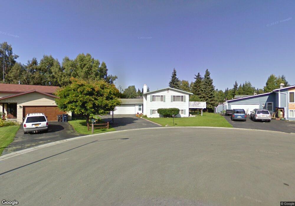
4910 Tiffin Cir Anchorage, AK 99508
University Area NeighborhoodEstimated Value: $199,000 - $488,993
3
Beds
3
Baths
1,192
Sq Ft
$327/Sq Ft
Est. Value
About This Home
This home is located at 4910 Tiffin Cir, Anchorage, AK 99508 and is currently estimated at $390,331, approximately $327 per square foot. 4910 Tiffin Cir is a home located in Anchorage Municipality with nearby schools including College Gate Elementary School, Wendler Middle School, and Bettye Davis East Anchorage High School.
Ownership History
Date
Name
Owned For
Owner Type
Purchase Details
Closed on
Oct 22, 1992
Sold by
Stroble Calvin L and Stroble Connie F
Bought by
Jackson Robert and Jackson Francine B
Current Estimated Value
Home Financials for this Owner
Home Financials are based on the most recent Mortgage that was taken out on this home.
Original Mortgage
$152,600
Interest Rate
7.86%
Mortgage Type
VA
Create a Home Valuation Report for This Property
The Home Valuation Report is an in-depth analysis detailing your home's value as well as a comparison with similar homes in the area
Home Values in the Area
Average Home Value in this Area
Purchase History
| Date | Buyer | Sale Price | Title Company |
|---|---|---|---|
| Jackson Robert | -- | -- |
Source: Public Records
Mortgage History
| Date | Status | Borrower | Loan Amount |
|---|---|---|---|
| Closed | Jackson Robert | $152,600 |
Source: Public Records
Tax History Compared to Growth
Tax History
| Year | Tax Paid | Tax Assessment Tax Assessment Total Assessment is a certain percentage of the fair market value that is determined by local assessors to be the total taxable value of land and additions on the property. | Land | Improvement |
|---|---|---|---|---|
| 2025 | $3,302 | $462,700 | $94,600 | $368,100 |
| 2024 | $3,302 | $429,500 | $94,600 | $334,900 |
| 2023 | $2,888 | $394,600 | $94,600 | $300,000 |
| 2022 | $3,245 | $392,700 | $94,600 | $298,100 |
| 2021 | $6,529 | $362,300 | $94,600 | $267,700 |
| 2020 | $2,583 | $353,100 | $94,600 | $258,500 |
| 2019 | $2,583 | $357,900 | $94,600 | $263,300 |
| 2018 | $4,869 | $346,900 | $94,600 | $252,300 |
| 2017 | $5,162 | $349,600 | $94,600 | $255,000 |
| 2016 | $4,377 | $341,900 | $92,600 | $249,300 |
| 2015 | $4,377 | $330,000 | $92,600 | $237,400 |
| 2014 | $4,377 | $325,600 | $84,500 | $241,100 |
Source: Public Records
Map
Nearby Homes
- 3305 Briarcliff Dr
- 000 Wesleyan Dr
- 4719 Mills Dr Unit 24
- 4838 Bryn Mawr Ct Unit 1
- 3310 Wells Cir
- 2942 Lily St
- 5013 Marlowe Ave
- 3215 Eastgate Place Unit 301
- 3668 Little Bear Place Unit 6
- 2601 Palmer Ct Unit D4
- 3910 Lynn Dr
- 2529 Wesleyan Dr
- 3948 Boniface Pkwy
- 2718 Lee St
- 2731 Lee St
- 5240 E 42nd Ave
- 3651 Mirage Cir
- 5527 Chilkoot Ct Unit 2
- 5018 E 43rd Ave Unit 5
- 5875 Kennyhill Dr
- 4915 Tiffin Cir
- 4920 Tiffin Cir
- 3317 Briarcliff Dr
- 3329 Briarcliff Dr
- 3405 Briarcliff Dr
- 3241 Briarcliff Dr
- 4925 Tiffin Cir
- 3450 Newcomb Dr
- 4938 Tiffin Cir
- 3419 Briarcliff Dr
- 3231 Briarcliff Dr
- 3464 Newcomb Dr
- 4937 Tiffin Cir
- 3221 Briarcliff Dr
- 3356 Newcomb Dr
- 3439 Briarcliff Dr
- 4962 Barat Cir
- 3330 Newcomb Dr
- 3340 Newcomb Dr
- 3240 Briarcliff Dr