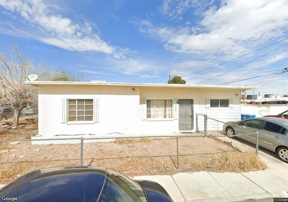
4912 Kansas Ave Unit none Las Vegas, NV 89107
Michael Way NeighborhoodEstimated Value: $275,244 - $346,000
3
Beds
1
Bath
954
Sq Ft
$320/Sq Ft
Est. Value
About This Home
This home is located at 4912 Kansas Ave Unit none, Las Vegas, NV 89107 and is currently estimated at $305,561, approximately $320 per square foot. 4912 Kansas Ave Unit none is a home located in Clark County with nearby schools including J.T. McWlliams Elementary School, Robert O Gibson Middle School, and Western High School.
Ownership History
Date
Name
Owned For
Owner Type
Purchase Details
Closed on
Jul 26, 2017
Sold by
Adame Xavier
Bought by
Adame Xavier and Bautista Vicente Adame
Current Estimated Value
Purchase Details
Closed on
Jul 24, 2012
Sold by
Cook Tommy
Bought by
Cook Melody
Purchase Details
Closed on
Jul 23, 2012
Sold by
Heintz James
Bought by
Adame Xavier
Purchase Details
Closed on
Aug 31, 2009
Sold by
Ballenger Tiffany
Bought by
Heintz James and Morrarty Nicklaus
Purchase Details
Closed on
Dec 18, 1995
Sold by
Mata Saldivar Miguel A and Mata Alicia
Bought by
Pangborn Timothy E and Heintz Judith
Create a Home Valuation Report for This Property
The Home Valuation Report is an in-depth analysis detailing your home's value as well as a comparison with similar homes in the area
Home Values in the Area
Average Home Value in this Area
Purchase History
| Date | Buyer | Sale Price | Title Company |
|---|---|---|---|
| Adame Xavier | -- | None Available | |
| Cook Melody | -- | Fidelity National Title | |
| Heintz James | -- | Fidelity National Title | |
| Adame Xavier | $56,000 | Fidelity National Title | |
| Heintz James | -- | None Available | |
| Pangborn Timothy E | $11,500 | Ati Title |
Source: Public Records
Tax History Compared to Growth
Tax History
| Year | Tax Paid | Tax Assessment Tax Assessment Total Assessment is a certain percentage of the fair market value that is determined by local assessors to be the total taxable value of land and additions on the property. | Land | Improvement |
|---|---|---|---|---|
| 2025 | $601 | $37,448 | $25,200 | $12,248 |
| 2024 | $601 | $37,448 | $25,200 | $12,248 |
| 2023 | $601 | $36,954 | $25,900 | $11,054 |
| 2022 | $557 | $30,955 | $21,000 | $9,955 |
| 2021 | $516 | $27,447 | $18,200 | $9,247 |
| 2020 | $476 | $24,056 | $15,050 | $9,006 |
| 2019 | $446 | $23,728 | $15,050 | $8,678 |
| 2018 | $426 | $18,650 | $10,500 | $8,150 |
| 2017 | $589 | $17,962 | $9,800 | $8,162 |
| 2016 | $400 | $14,937 | $7,000 | $7,937 |
| 2015 | $398 | $12,952 | $5,250 | $7,702 |
| 2014 | $386 | $11,429 | $3,780 | $7,649 |
Source: Public Records
Map
Nearby Homes
- 4901 Nebraska Ave
- 104 Stanford St
- 421 Harvard St
- 424 Stanford St
- 0 N Decatur Blvd
- 5117 Arbor Way
- 504 N Minnesota St
- 605 N Yale St
- 605 Stanford St
- 5220 Mission Carmel Ln Unit 103
- 5250 Mission Carmel Ln Unit 102
- 5250 Mission Carmel Ln Unit 204
- 220 Mission Catalina Ln Unit 207
- 5300 Sugarfoot Ave
- 5260 Mission Monterey Ln Unit 105
- 230 Mission Newport Ln Unit 104
- 5261 Mission Carmel Ln Unit 204
- 601 Huntington St
- 221 Mission Catalina Ln Unit 101
- 220 Mission Newport Ln Unit 203