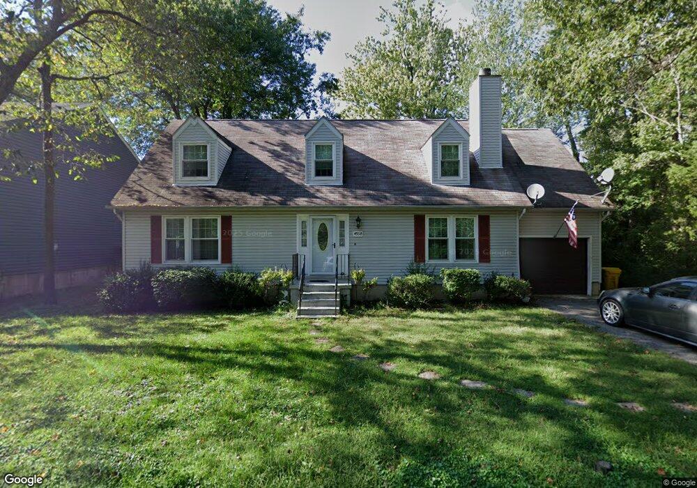
4918 Elm St Shady Side, MD 20764
Estimated Value: $443,000 - $476,000
--
Bed
2
Baths
1,782
Sq Ft
$258/Sq Ft
Est. Value
About This Home
This home is located at 4918 Elm St, Shady Side, MD 20764 and is currently estimated at $460,146, approximately $258 per square foot. 4918 Elm St is a home located in Anne Arundel County with nearby schools including Shady Side Elementary School, Southern Middle School, and Southern High School.
Ownership History
Date
Name
Owned For
Owner Type
Purchase Details
Closed on
Apr 13, 2005
Sold by
Canning David J
Bought by
Anderson Robert J and Phelps Barbara J
Current Estimated Value
Home Financials for this Owner
Home Financials are based on the most recent Mortgage that was taken out on this home.
Original Mortgage
$212,280
Outstanding Balance
$110,185
Interest Rate
5.87%
Mortgage Type
New Conventional
Estimated Equity
$349,961
Purchase Details
Closed on
Dec 31, 2003
Sold by
Hamel Dale A
Bought by
Canning David J and Canning Jennifer L
Create a Home Valuation Report for This Property
The Home Valuation Report is an in-depth analysis detailing your home's value as well as a comparison with similar homes in the area
Home Values in the Area
Average Home Value in this Area
Purchase History
| Date | Buyer | Sale Price | Title Company |
|---|---|---|---|
| Anderson Robert J | $349,000 | -- | |
| Canning David J | $299,900 | -- |
Source: Public Records
Mortgage History
| Date | Status | Borrower | Loan Amount |
|---|---|---|---|
| Open | Anderson Robert J | $212,280 | |
| Closed | Canning David J | -- |
Source: Public Records
Tax History Compared to Growth
Tax History
| Year | Tax Paid | Tax Assessment Tax Assessment Total Assessment is a certain percentage of the fair market value that is determined by local assessors to be the total taxable value of land and additions on the property. | Land | Improvement |
|---|---|---|---|---|
| 2025 | $3,471 | $339,467 | -- | -- |
| 2024 | $3,471 | $318,333 | $0 | $0 |
| 2023 | $3,362 | $297,200 | $136,100 | $161,100 |
| 2022 | $3,154 | $294,167 | $0 | $0 |
| 2021 | $6,173 | $291,133 | $0 | $0 |
| 2020 | $2,999 | $288,100 | $136,100 | $152,000 |
| 2019 | $2,948 | $278,467 | $0 | $0 |
| 2018 | $198 | $268,833 | $0 | $0 |
| 2017 | $2,753 | $259,200 | $0 | $0 |
| 2016 | $198 | $257,200 | $0 | $0 |
| 2015 | $198 | $255,200 | $0 | $0 |
| 2014 | -- | $253,200 | $0 | $0 |
Source: Public Records
Map
Nearby Homes
- 4913 Chestnut St
- 4912 Beech St
- 1302 Spruce St
- 4908 Aspen St
- 4992 Lerch Dr
- 1419 Shady Rest Rd
- 4900 Thomas Dr
- 4938 Rullman Rd
- 4846 Woods Wharf Rd
- 4907 Quince St
- 6152 Shady Side Rd
- 6508 Shady Side Rd
- 1133 Steamboat Rd
- 6512 Shady Side Rd
- 6118 Shady Side Rd
- 0 Shady Side Rd Unit MDAA2113156
- 0 Shady Side Rd Unit MDAA2113166
- 6070 Shady Side Rd
- 1428 Haile Pkwy
- 1408 & 1410 Haile Pkwy