Estimated Value: $394,000 - $572,000
3
Beds
1
Bath
2,208
Sq Ft
$209/Sq Ft
Est. Value
About This Home
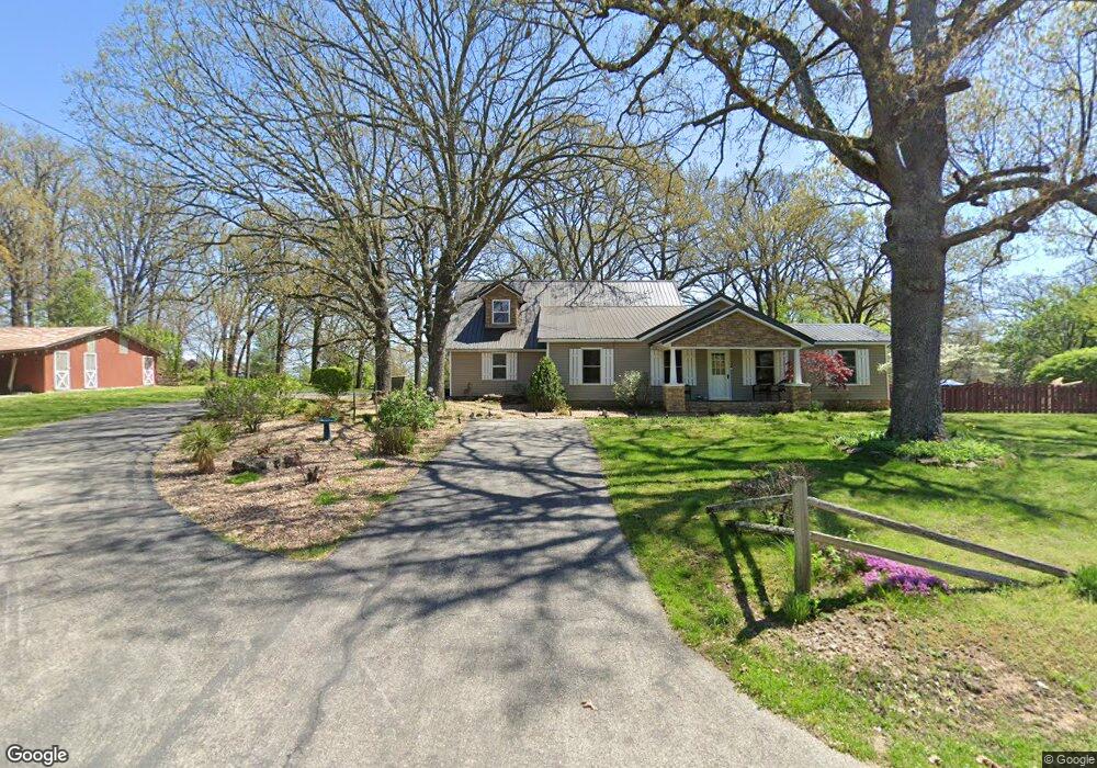
This home is located at 492 Maynard Rd, Nixa, MO 65714 and is currently estimated at $460,494, approximately $208 per square foot. 492 Maynard Rd is a home with nearby schools including Espy Elementary School, Nicholas A. Inman Intermediate School, and Nixa Junior High School.
Ownership History
Date
Name
Owned For
Owner Type
Purchase Details
Closed on
Dec 30, 2019
Sold by
Long Craig A and Coley Travis A
Bought by
Long Craig A and Coley Travis A
Current Estimated Value
Home Financials for this Owner
Home Financials are based on the most recent Mortgage that was taken out on this home.
Original Mortgage
$229,955
Interest Rate
4.62%
Mortgage Type
FHA
Purchase Details
Closed on
Sep 6, 2007
Sold by
Long Christina
Bought by
Long Craig
Create a Home Valuation Report for This Property
The Home Valuation Report is an in-depth analysis detailing your home's value as well as a comparison with similar homes in the area
Home Values in the Area
Average Home Value in this Area
Purchase History
| Date | Buyer | Sale Price | Title Company |
|---|---|---|---|
| Long Craig A | -- | Great Amer Ttl All Branches | |
| Long Craig | -- | None Available |
Source: Public Records
Mortgage History
| Date | Status | Borrower | Loan Amount |
|---|---|---|---|
| Closed | Long Craig A | $229,955 |
Source: Public Records
Tax History
| Year | Tax Paid | Tax Assessment Tax Assessment Total Assessment is a certain percentage of the fair market value that is determined by local assessors to be the total taxable value of land and additions on the property. | Land | Improvement |
|---|---|---|---|---|
| 2025 | $1,998 | $35,660 | -- | -- |
| 2024 | $1,998 | $33,670 | -- | -- |
| 2023 | $1,998 | $33,670 | $0 | $0 |
| 2022 | $1,706 | $28,710 | $0 | $0 |
| 2021 | $1,707 | $28,710 | $0 | $0 |
| 2020 | $1,560 | $25,100 | $0 | $0 |
| 2019 | $1,560 | $25,100 | $0 | $0 |
| 2018 | $1,447 | $25,100 | $0 | $0 |
| 2017 | $1,447 | $25,100 | $0 | $0 |
| 2016 | $1,061 | $18,720 | $0 | $0 |
| 2015 | $1,063 | $18,720 | $18,720 | $0 |
| 2014 | $1,030 | $18,620 | $0 | $0 |
| 2013 | $1,031 | $18,620 | $0 | $0 |
| 2011 | -- | $32,160 | $0 | $0 |
Source: Public Records
Map
Nearby Homes
- 5 Ac Dewberry Rd
- 188 Highland Dr
- 184 Apricot Ct
- 1353 Norfolk Ave
- Lot #4 N Ginger Ln
- 1344 W Berkshire Ave
- 145 S Blazing Star Ln
- 000 W Copper Creek Dr
- 1209 W Mount Vernon St
- 1205 W Yellowstone St
- 2063 Olde Gate Rd
- 120 N Nicholas Rd
- 1334 W Mount Vernon St
- 605 Glen Oaks Cir
- 1343 W Tracker Rd
- 1266 W Bridgewood Place
- 1257 W Bridgewood Place
- 601 S Gregg Rd
- 805 W Briarwood Ln
- 912 Wesley Ave
- 493 Maynard Rd
- 450 Maynard Rd
- 424 Maynard Rd
- 549 Maynard Rd
- 1586 W Dewberry Rd
- 1612 W Dewberry Rd
- 396 Maynard Rd
- 399 Maynard Rd
- 0 Maynard Rd Unit 10800249
- 0 Maynard Rd Unit 10800250
- 0 Maynard Rd Unit 10800248
- 0 Maynard Rd Unit 10811612
- 0 Maynard Rd Unit 10811611
- 0 Maynard Rd Unit 10813161
- 0 Maynard Rd Unit 10813160
- 0 Maynard Rd Unit 10823787
- 0 Maynard Rd Unit 10903859
- 0 Maynard Rd Unit 10905796
- 0 Maynard Rd Unit 10907714
- 0 Maynard Rd Unit 10911708
Your Personal Tour Guide
Ask me questions while you tour the home.