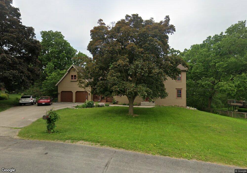
4920 Highwood Cir Middleton, WI 53562
Town of Middleton NeighborhoodEstimated Value: $820,000 - $1,137,000
--
Bed
--
Bath
--
Sq Ft
2.18
Acres
About This Home
This home is located at 4920 Highwood Cir, Middleton, WI 53562 and is currently estimated at $1,010,811. 4920 Highwood Cir is a home located in Dane County with nearby schools including Sunset Ridge Elementary School, Glacier Creek Middle School, and Middleton High School.
Ownership History
Date
Name
Owned For
Owner Type
Purchase Details
Closed on
May 15, 2008
Sold by
Marti Michael G and Marti Karen R
Bought by
Vannest Matthew L and Van Nest Andrea L
Current Estimated Value
Home Financials for this Owner
Home Financials are based on the most recent Mortgage that was taken out on this home.
Original Mortgage
$70,000
Outstanding Balance
$44,446
Interest Rate
5.93%
Mortgage Type
Purchase Money Mortgage
Estimated Equity
$966,365
Create a Home Valuation Report for This Property
The Home Valuation Report is an in-depth analysis detailing your home's value as well as a comparison with similar homes in the area
Home Values in the Area
Average Home Value in this Area
Purchase History
| Date | Buyer | Sale Price | Title Company |
|---|---|---|---|
| Vannest Matthew L | $570,000 | None Available |
Source: Public Records
Mortgage History
| Date | Status | Borrower | Loan Amount |
|---|---|---|---|
| Open | Vannest Matthew L | $70,000 | |
| Open | Vannest Matthew L | $385,000 |
Source: Public Records
Tax History Compared to Growth
Tax History
| Year | Tax Paid | Tax Assessment Tax Assessment Total Assessment is a certain percentage of the fair market value that is determined by local assessors to be the total taxable value of land and additions on the property. | Land | Improvement |
|---|---|---|---|---|
| 2024 | $10,276 | $644,300 | $205,000 | $439,300 |
| 2023 | $9,923 | $644,300 | $205,000 | $439,300 |
| 2021 | $9,664 | $644,300 | $205,000 | $439,300 |
| 2020 | $9,714 | $572,600 | $180,200 | $392,400 |
| 2019 | $9,089 | $505,100 | $150,200 | $354,900 |
| 2018 | $8,354 | $505,100 | $150,200 | $354,900 |
| 2017 | $8,669 | $505,100 | $150,200 | $354,900 |
| 2016 | $8,479 | $488,500 | $150,200 | $338,300 |
| 2015 | $8,826 | $475,700 | $150,200 | $325,500 |
| 2014 | $8,556 | $475,700 | $150,200 | $325,500 |
| 2013 | $7,945 | $475,700 | $150,200 | $325,500 |
Source: Public Records
Map
Nearby Homes
- 8007 Airport Rd
- 4817 Parmenter St
- Lot 14 Belle Farm
- 4029 Serenbe St
- Lot 7 Belle Farm
- Lot 9 Belle Farm
- Lot 6 Belle Farm
- 4043 Serenbe St
- Lot 4 Belle Farm
- Lot 5 Belle Farm
- Lot 31 Belle Farm
- Lot 24 Belle Farm
- Lot 29 Belle Farm
- Lot 28 Belle Farm
- Lot 27 Belle Farm
- Lot 39 Belle Farm
- Lot 25 Belle Farm
- Lot 41 Belle Farm
- Lot 42 Belle Farm
- 7418 Century Ave
- 4924 Highwood Cir
- 4916 Highwood Cir
- 4925 Highwood Cir
- 4928 Highwood Cir
- 4910 Highwood Cir
- 4903 Highwood Cir
- 4906 Highwood Cir
- Lot 0 Old Creek Rd
- L3 Nature's Cove
- 1721 & 173 Middleton St
- L9 Daybreak Ct
- L8 Daybreak Ct
- LOT 9 Daybreak Ct
- Lot 8 Daybreak Ct
- LOT 46 Sauk Point Estates
- LOT 45 Prairie Estates
- 77Ac Airport Rd
- 202Ac Airport Rd
- 2.8 Acres Mineral Point Rd
- L 11 Rocky Dell Estates