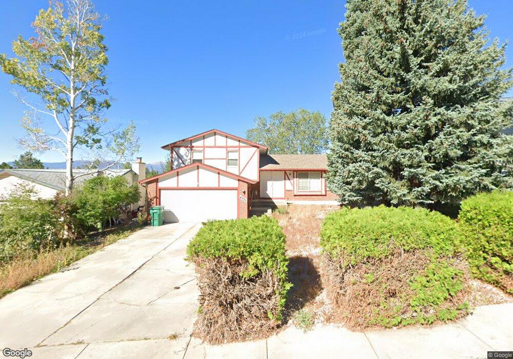
4920 Molly Pond Ct Colorado Springs, CO 80917
Old Farms NeighborhoodEstimated Value: $432,168 - $473,000
4
Beds
4
Baths
1,616
Sq Ft
$283/Sq Ft
Est. Value
About This Home
This home is located at 4920 Molly Pond Ct, Colorado Springs, CO 80917 and is currently estimated at $457,292, approximately $282 per square foot. 4920 Molly Pond Ct is a home located in El Paso County with nearby schools including Scott Elementary School, Jenkins Middle School, and Doherty High School.
Ownership History
Date
Name
Owned For
Owner Type
Purchase Details
Closed on
Jul 24, 2008
Sold by
Burnside Thongbai
Bought by
Smith Thongbai
Current Estimated Value
Home Financials for this Owner
Home Financials are based on the most recent Mortgage that was taken out on this home.
Original Mortgage
$57,914
Interest Rate
6.4%
Mortgage Type
Unknown
Purchase Details
Closed on
Sep 12, 1997
Sold by
Burnside James M
Bought by
Burnside Thongbai
Purchase Details
Closed on
Nov 1, 1983
Bought by
Smith Thongbai
Create a Home Valuation Report for This Property
The Home Valuation Report is an in-depth analysis detailing your home's value as well as a comparison with similar homes in the area
Home Values in the Area
Average Home Value in this Area
Purchase History
| Date | Buyer | Sale Price | Title Company |
|---|---|---|---|
| Smith Thongbai | -- | Unified Title Company | |
| Burnside Thongbai | -- | -- | |
| Smith Thongbai | -- | -- |
Source: Public Records
Mortgage History
| Date | Status | Borrower | Loan Amount |
|---|---|---|---|
| Closed | Smith Thongbai | $57,914 |
Source: Public Records
Tax History Compared to Growth
Tax History
| Year | Tax Paid | Tax Assessment Tax Assessment Total Assessment is a certain percentage of the fair market value that is determined by local assessors to be the total taxable value of land and additions on the property. | Land | Improvement |
|---|---|---|---|---|
| 2025 | $1,518 | $31,780 | -- | -- |
| 2024 | $1,403 | $31,720 | $5,490 | $26,230 |
| 2023 | $1,403 | $31,720 | $5,490 | $26,230 |
| 2022 | $1,319 | $23,570 | $4,170 | $19,400 |
| 2021 | $1,431 | $24,250 | $4,290 | $19,960 |
| 2020 | $1,425 | $20,990 | $3,720 | $17,270 |
| 2019 | $1,417 | $20,990 | $3,720 | $17,270 |
| 2018 | $1,319 | $17,970 | $3,240 | $14,730 |
| 2017 | $1,249 | $17,970 | $3,240 | $14,730 |
| 2016 | $970 | $16,740 | $2,710 | $14,030 |
| 2015 | $967 | $16,740 | $2,710 | $14,030 |
| 2014 | $942 | $15,650 | $2,710 | $12,940 |
Source: Public Records
Map
Nearby Homes
- 4958 Wood Brook Ct
- 4878 S Old Brook Cir
- 4842 S Old Brook Cir
- 4835 W Old Farm Cir
- 5119 Lewisia Point
- 4774 Bunchberry Ln
- 5125 Lewisia Point
- 4955 Chickweed Dr
- 5242 Windgate Ct
- 4966 Galileo Dr
- 5441 E Old Farm Cir
- 5235 Quasar Ct
- 5081 Willowbrook Rd
- 5210 Coneflower Ln
- 4504 Bell Flower Dr
- 4636 Winewood Village Dr
- 4652 Excalibur Ct
- 5002 Barnes Rd
- 5050 Copernicus Way
- 5117 Solar Ridge Dr
- 4930 Molly Pond Ct
- 4910 Molly Pond Ct
- 5050 W Old Farm Cir
- 4919 Wood Brook Ct
- 4927 Wood Brook Ct
- 4940 Molly Pond Ct
- 4935 Wood Brook Ct
- 4911 Wood Brook Ct
- 4925 Molly Pond Ct
- 5120 W Old Farm Cir
- 4943 Wood Brook Ct
- 4951 Wood Brook Ct
- 4950 Molly Pond Ct
- 5085 W Old Farm Cir
- 4935 Molly Pond Ct
- 5115 W Old Farm Cir
- 5065 W Old Farm Cir
- 5125 W Old Farm Cir
- 4959 Wood Brook Ct
- 5130 W Old Farm Cir