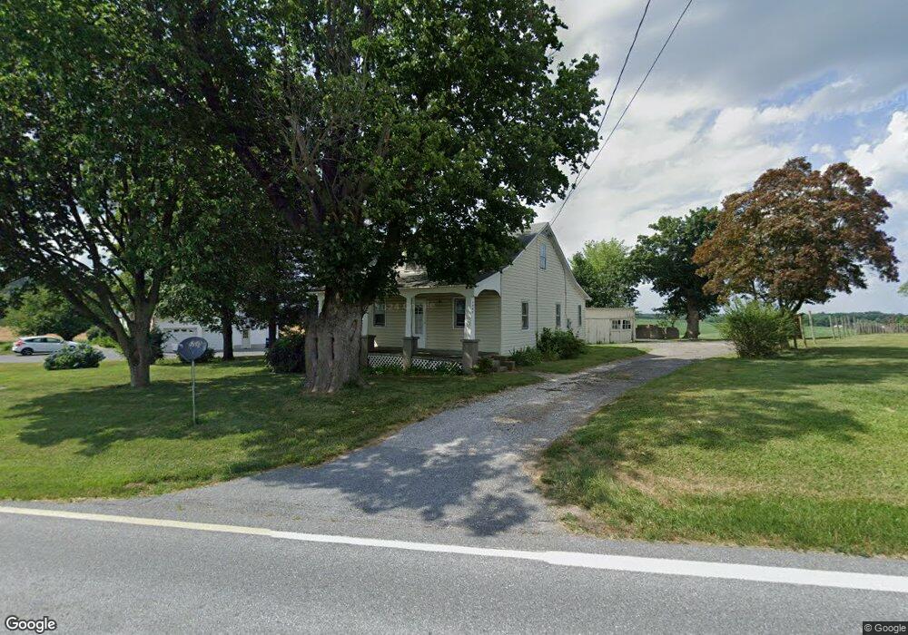
4922 Black Rock Rd Hampstead, MD 21074
Estimated Value: $221,796 - $460,000
--
Bed
1
Bath
1,134
Sq Ft
$285/Sq Ft
Est. Value
About This Home
This home is located at 4922 Black Rock Rd, Hampstead, MD 21074 and is currently estimated at $322,699, approximately $284 per square foot. 4922 Black Rock Rd is a home located in Baltimore County with nearby schools including Fifth District Elementary School, Hereford Middle School, and Hereford High School.
Ownership History
Date
Name
Owned For
Owner Type
Purchase Details
Closed on
Aug 5, 2015
Sold by
Armacost Richard S
Bought by
Armacost Zachary Scott and Armacost Kyle Lee
Current Estimated Value
Purchase Details
Closed on
Jul 16, 2013
Sold by
Cole Donald E and Cole Betty L
Bought by
Armacost Richard S
Purchase Details
Closed on
Nov 25, 1991
Sold by
Ruby Jesse S
Bought by
Cole Donald E and Cole Betty L
Create a Home Valuation Report for This Property
The Home Valuation Report is an in-depth analysis detailing your home's value as well as a comparison with similar homes in the area
Home Values in the Area
Average Home Value in this Area
Purchase History
| Date | Buyer | Sale Price | Title Company |
|---|---|---|---|
| Armacost Zachary Scott | -- | None Available | |
| Armacost Richard S | -- | None Available | |
| Cole Donald E | $60,000 | -- |
Source: Public Records
Tax History Compared to Growth
Tax History
| Year | Tax Paid | Tax Assessment Tax Assessment Total Assessment is a certain percentage of the fair market value that is determined by local assessors to be the total taxable value of land and additions on the property. | Land | Improvement |
|---|---|---|---|---|
| 2025 | $2,170 | $183,000 | $79,600 | $103,400 |
| 2024 | $2,170 | $175,667 | $0 | $0 |
| 2023 | $2,100 | $168,333 | $0 | $0 |
| 2022 | $1,994 | $161,000 | $67,900 | $93,100 |
| 2021 | $1,859 | $154,733 | $0 | $0 |
| 2020 | $1,859 | $148,467 | $0 | $0 |
| 2019 | $1,783 | $142,200 | $67,900 | $74,300 |
| 2018 | $1,720 | $136,967 | $0 | $0 |
| 2017 | $1,596 | $131,733 | $0 | $0 |
| 2016 | -- | $126,500 | $0 | $0 |
| 2015 | $1,726 | $126,500 | $0 | $0 |
| 2014 | $1,726 | $126,500 | $0 | $0 |
Source: Public Records
Map
Nearby Homes
- 1124 Cedarbrook Rd
- 4703 Barbed Ct
- 1208 Wynside Ln
- 1003 Scarlet Oak Ct Unit 1A
- 0 Trenton Mill Rd Unit MDBC2117946
- 613 Hanover Pike
- 4240 Crystal Ct Unit 3D
- 4230 Crystal Ct Unit 3C
- 4138 Hillcrest Ave
- 16535 Trenton Rd
- 920 N Houcksville Rd
- 16338 Trenton Rd
- 1330 N Main St
- 16357 Trenton Rd
- 4150 Sommerfield Dr
- 4100 Black Rock Rd
- 0 Hanover Pike Unit MDCR2024542
- 1151 Caton Rd
- 16742 Ridge Rd
- 4131 Shanelle Ct
- 4924 Black Rock Rd
- 4910 Black Rock Rd
- 4931 Black Rock Rd
- 4900 Black Rock Rd
- 4830 Black Rock Rd
- 4828 Black Rock Rd
- 4826 Black Rock Rd
- 4824 Black Rock Rd
- 4822 Black Rock Rd
- 5026 Black Rock Rd
- 4555 Lower Beckleysville Rd
- 5030 Black Rock Rd
- 5100 Black Rock Rd
- 16134 Hanover Pike
- 17420 Grace Rd
- 5025 Black Rock Rd
- 5111 Black Rock Rd
- 5109 Black Rock Rd Unit A
- 5109 Black Rock Rd
- 4701 Black Rock Rd