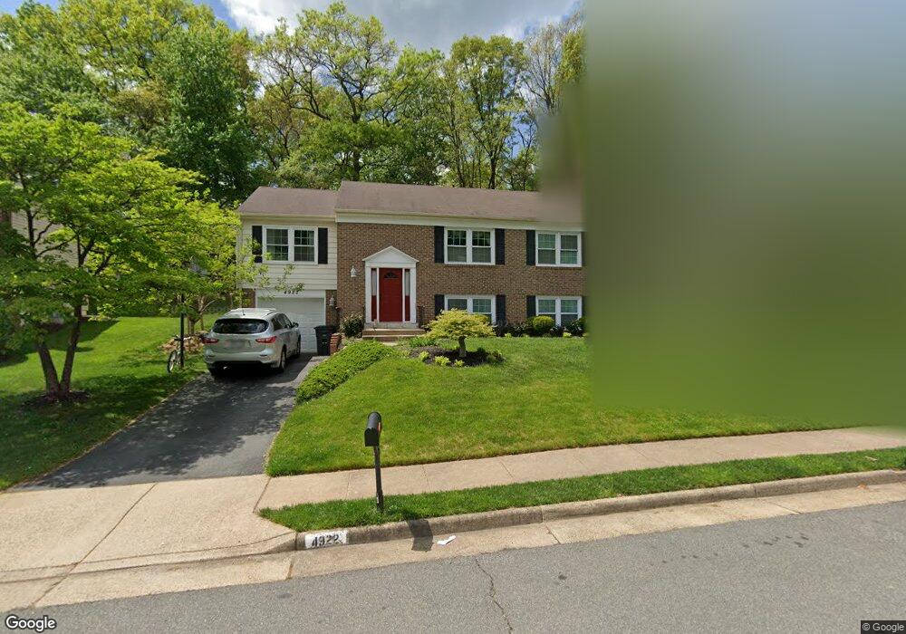
4922 King Solomon Dr Annandale, VA 22003
Estimated Value: $678,000 - $900,000
4
Beds
3
Baths
1,356
Sq Ft
$592/Sq Ft
Est. Value
About This Home
This home is located at 4922 King Solomon Dr, Annandale, VA 22003 and is currently estimated at $802,185, approximately $591 per square foot. 4922 King Solomon Dr is a home located in Fairfax County with nearby schools including Canterbury Woods Elementary School, Frost Middle School, and W. T. Woodson High School.
Ownership History
Date
Name
Owned For
Owner Type
Purchase Details
Closed on
Sep 3, 1996
Sold by
Yoder Kathy G
Bought by
Lee Kwang B
Current Estimated Value
Home Financials for this Owner
Home Financials are based on the most recent Mortgage that was taken out on this home.
Original Mortgage
$169,200
Outstanding Balance
$14,503
Interest Rate
8.18%
Estimated Equity
$787,682
Create a Home Valuation Report for This Property
The Home Valuation Report is an in-depth analysis detailing your home's value as well as a comparison with similar homes in the area
Home Values in the Area
Average Home Value in this Area
Purchase History
| Date | Buyer | Sale Price | Title Company |
|---|---|---|---|
| Lee Kwang B | $211,500 | -- |
Source: Public Records
Mortgage History
| Date | Status | Borrower | Loan Amount |
|---|---|---|---|
| Open | Lee Kwang B | $169,200 |
Source: Public Records
Tax History Compared to Growth
Tax History
| Year | Tax Paid | Tax Assessment Tax Assessment Total Assessment is a certain percentage of the fair market value that is determined by local assessors to be the total taxable value of land and additions on the property. | Land | Improvement |
|---|---|---|---|---|
| 2025 | $8,404 | $772,140 | $314,000 | $458,140 |
| 2024 | $8,404 | $725,440 | $299,000 | $426,440 |
| 2023 | $7,604 | $673,830 | $279,000 | $394,830 |
| 2022 | $7,385 | $645,820 | $259,000 | $386,820 |
| 2021 | $7,147 | $609,010 | $249,000 | $360,010 |
| 2020 | $6,937 | $586,160 | $240,000 | $346,160 |
| 2019 | $6,652 | $562,080 | $226,000 | $336,080 |
| 2018 | $5,748 | $499,810 | $205,000 | $294,810 |
| 2017 | $5,803 | $499,810 | $205,000 | $294,810 |
| 2016 | $5,597 | $483,120 | $205,000 | $278,120 |
| 2015 | $5,392 | $483,120 | $205,000 | $278,120 |
| 2014 | $5,194 | $466,420 | $199,000 | $267,420 |
Source: Public Records
Map
Nearby Homes
- 4903 King David Blvd
- 5009 King David Blvd
- 5055 Kenerson Dr
- 5090 Queens Wood Dr
- 5254 Queens Wood Dr
- 4721 Springbrook Dr
- 5037 Head Ct
- 4869 Nash Dr
- 5112 Linette Ln
- 4906 Mcfarland Dr
- 5307 Amber Ct
- 5103 Cicero Ct
- 8928 Cheltonham Place
- 4512 Sleaford Rd
- 8909 Victoria Rd
- 4314 Selkirk Dr
- 9513 Burdett Rd
- 4301 Braeburn Dr
- 4353 Starr Jordan Dr
- 4222 Braeburn Dr
- 4920 King Solomon Dr
- 4924 King Solomon Dr
- 4918 King Solomon Dr
- 4926 King Solomon Dr
- 4921 King Solomon Dr
- 4923 King Solomon Dr
- 4925 King Solomon Dr
- 5005 Kenerson Dr
- 5007 Kenerson Dr
- 4916 King Solomon Dr
- 4928 King Solomon Dr
- 5003 Kenerson Dr
- 4917 King Solomon Dr
- 5009 Kenerson Dr
- 9220 Alyssum Way
- 4918 Gloxinia Ct
- 5001 Kenerson Dr
- 5000 King Solomon Dr
- 5011 Kenerson Dr
- 4924 Gloxinia Ct