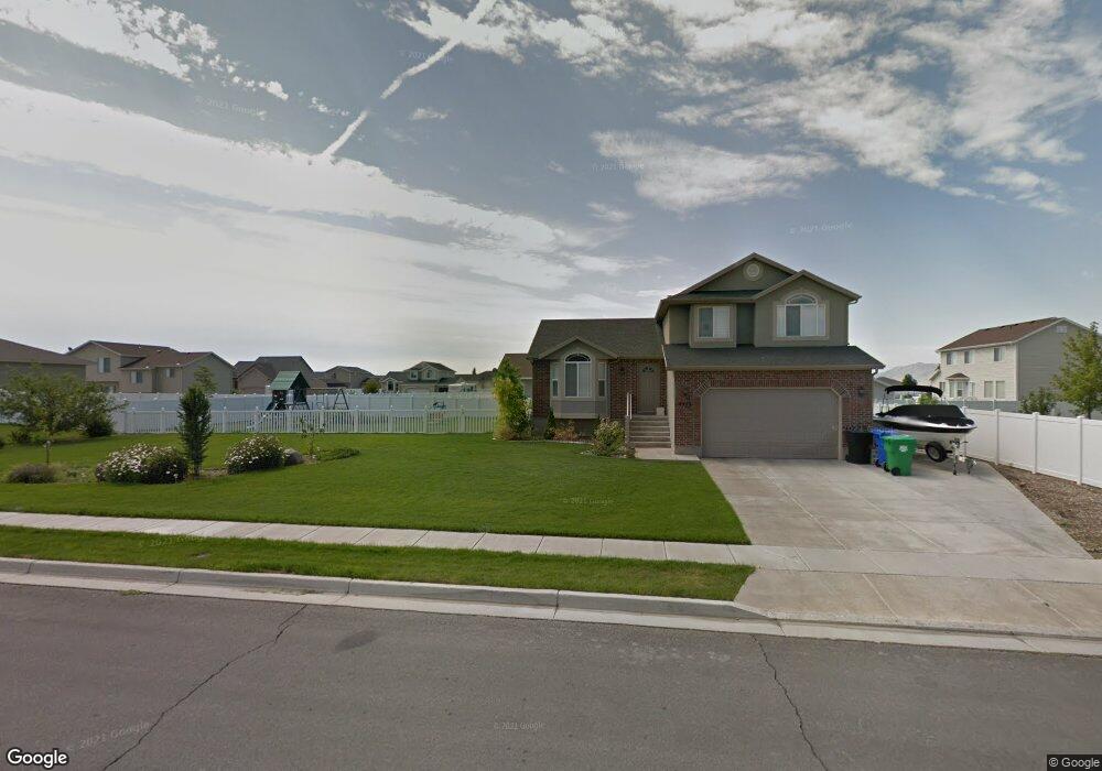
4923 W Mallard Dr West Point, UT 84015
Estimated Value: $538,000 - $561,000
3
Beds
3
Baths
2,196
Sq Ft
$249/Sq Ft
Est. Value
About This Home
This home is located at 4923 W Mallard Dr, West Point, UT 84015 and is currently estimated at $547,456, approximately $249 per square foot. 4923 W Mallard Dr is a home located in Davis County with nearby schools including West Point School, West Point Junior High School, and Syracuse High School.
Ownership History
Date
Name
Owned For
Owner Type
Purchase Details
Closed on
May 19, 2017
Sold by
Hill Stephen R and Hill Ikristy T
Bought by
Sterling Fiduciaries Llc
Current Estimated Value
Home Financials for this Owner
Home Financials are based on the most recent Mortgage that was taken out on this home.
Original Mortgage
$237,405
Outstanding Balance
$197,432
Interest Rate
4.1%
Mortgage Type
New Conventional
Estimated Equity
$350,024
Purchase Details
Closed on
May 17, 2017
Sold by
Yarosik Robert M and Yarosik Carol A
Bought by
Crook Matthew and Crook Leann
Home Financials for this Owner
Home Financials are based on the most recent Mortgage that was taken out on this home.
Original Mortgage
$237,405
Outstanding Balance
$197,432
Interest Rate
4.1%
Mortgage Type
New Conventional
Estimated Equity
$350,024
Purchase Details
Closed on
Jan 27, 2006
Sold by
Mike Schultz Construction Inc
Bought by
Yarosik Robert M and Yarosik Carol A
Home Financials for this Owner
Home Financials are based on the most recent Mortgage that was taken out on this home.
Original Mortgage
$40,888
Interest Rate
6.28%
Mortgage Type
Credit Line Revolving
Purchase Details
Closed on
Nov 9, 2004
Sold by
S M Carter Co
Bought by
Mike Schultz Construction Inc
Home Financials for this Owner
Home Financials are based on the most recent Mortgage that was taken out on this home.
Original Mortgage
$75,200
Interest Rate
5.77%
Mortgage Type
Purchase Money Mortgage
Purchase Details
Closed on
Oct 1, 2004
Sold by
Paice Farms Llc
Bought by
S M Carter Co
Home Financials for this Owner
Home Financials are based on the most recent Mortgage that was taken out on this home.
Original Mortgage
$75,200
Interest Rate
5.77%
Mortgage Type
Purchase Money Mortgage
Purchase Details
Closed on
Apr 16, 2003
Sold by
Mark Higley Construction Lc and Boothe Gordon
Bought by
Paice Farms Llc
Home Financials for this Owner
Home Financials are based on the most recent Mortgage that was taken out on this home.
Original Mortgage
$850,000
Interest Rate
6.22%
Mortgage Type
Seller Take Back
Create a Home Valuation Report for This Property
The Home Valuation Report is an in-depth analysis detailing your home's value as well as a comparison with similar homes in the area
Home Values in the Area
Average Home Value in this Area
Purchase History
| Date | Buyer | Sale Price | Title Company |
|---|---|---|---|
| Sterling Fiduciaries Llc | -- | -- | |
| Crook Matthew | -- | Mountain View Title | |
| Yarosik Robert M | -- | Heritage West Title Ins Agen | |
| Mike Schultz Construction Inc | -- | Security Title | |
| S M Carter Co | -- | Security Title Company | |
| Paice Farms Llc | -- | Heritage West Title Insuranc |
Source: Public Records
Mortgage History
| Date | Status | Borrower | Loan Amount |
|---|---|---|---|
| Open | Sterling Fiduciaries Llc | $237,405 | |
| Closed | Crook Matthew | $300,000 | |
| Previous Owner | Yarosik Robert M | $40,888 | |
| Previous Owner | Yarosik Robert M | $163,548 | |
| Previous Owner | S M Carter Co | $75,200 | |
| Previous Owner | Paice Farms Llc | $850,000 |
Source: Public Records
Tax History
| Year | Tax Paid | Tax Assessment Tax Assessment Total Assessment is a certain percentage of the fair market value that is determined by local assessors to be the total taxable value of land and additions on the property. | Land | Improvement |
|---|---|---|---|---|
| 2025 | $2,785 | $256,300 | $115,457 | $140,843 |
| 2024 | $2,821 | $260,700 | $103,932 | $156,768 |
| 2023 | $2,601 | $442,000 | $130,338 | $311,662 |
| 2022 | $2,802 | $260,701 | $68,019 | $192,682 |
| 2021 | $2,566 | $357,000 | $105,422 | $251,578 |
| 2020 | $2,256 | $309,000 | $88,719 | $220,281 |
| 2019 | $2,201 | $297,000 | $86,028 | $210,972 |
| 2018 | $2,024 | $269,000 | $85,690 | $183,310 |
| 2016 | $1,717 | $119,681 | $33,171 | $86,510 |
| 2015 | $1,719 | $113,576 | $33,171 | $80,405 |
| 2014 | $1,610 | $107,618 | $33,171 | $74,447 |
| 2013 | -- | $111,216 | $32,338 | $78,878 |
Source: Public Records
Map
Nearby Homes
- 113 N 4950 W
- 4857 Pintail Way
- 4669 W 75 N
- 4901 W 650 N
- 477 N 4500 W
- 4362 West St Unit 106
- 4358 West St Unit 105
- 120 N 4325 W
- 356 S 4300 W Unit 611
- 364 S 4300 W Unit 610
- 372 S 4300 W Unit 609
- 4260 W 350 S
- 388 S 4300 W Unit 607
- 396 S 4300 W
- 387 S 4250 W
- 1156 N 5150 W
- 696 S 4500 W
- 114 3830 W
- 96 3830 W
- 3833 W 50 S Unit 429
- 4924 W 175 N
- 220 N 4950 W
- 190 N 4950 W
- 4911 W Mallard Dr
- 4911 W Mallard Dr
- 4926 W 250 N
- 4912 W 175 N
- 4912 Morning Dove Dr
- 4912 Morning Dove Dr
- 4938 W 250 N
- 4914 W 250 N
- 4914 W Mallard Dr
- 4914 W Mallard Dr
- 4921 W 175 N
- 4921 Morning Dove Dr Unit 45
- 4921 Morning Dove Dr
- 221 N 4875 W
- 168 N 4950 W
- 4909 W 175 N
- 4925 W 300 N
Your Personal Tour Guide
Ask me questions while you tour the home.