Estimated Value: $203,000 - $297,000
5
Beds
2
Baths
2,171
Sq Ft
$118/Sq Ft
Est. Value
About This Home
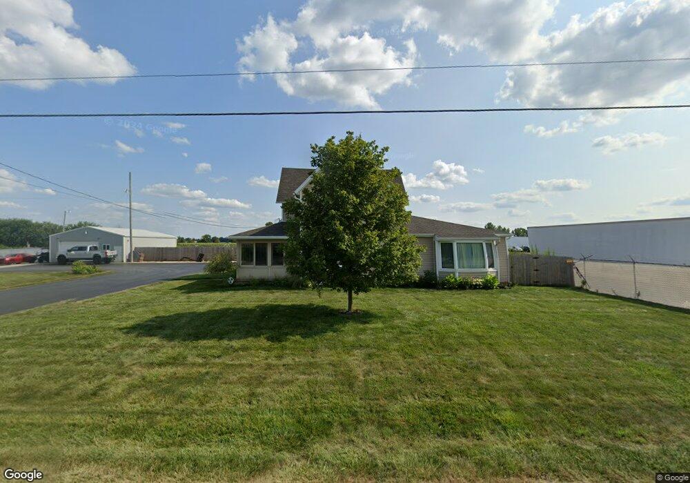
This home is located at 4925 Us Highway 20a, Delta, OH 43515 and is currently estimated at $255,946, approximately $117 per square foot. 4925 Us Highway 20a is a home located in Fulton County with nearby schools including Delta Elementary School, Pike-Delta-York Middle School, and Pike-Delta-York High School.
Ownership History
Date
Name
Owned For
Owner Type
Purchase Details
Closed on
Jun 26, 2017
Sold by
M & K Metal Processors Inc
Bought by
Ipi Delta East Llc
Current Estimated Value
Purchase Details
Closed on
Mar 7, 2005
Sold by
Lunning Phyllis A and Gunn Frances S
Bought by
M & K Metal Processors Inc
Purchase Details
Closed on
Jan 1, 1990
Bought by
Dalesandro Maria R
Create a Home Valuation Report for This Property
The Home Valuation Report is an in-depth analysis detailing your home's value as well as a comparison with similar homes in the area
Home Values in the Area
Average Home Value in this Area
Purchase History
| Date | Buyer | Sale Price | Title Company |
|---|---|---|---|
| Ipi Delta East Llc | $250,000 | None Available | |
| M & K Metal Processors Inc | $68,000 | -- | |
| Dalesandro Maria R | -- | -- |
Source: Public Records
Mortgage History
| Date | Status | Borrower | Loan Amount |
|---|---|---|---|
| Closed | Ipi Delta East Llc | $0 |
Source: Public Records
Tax History Compared to Growth
Tax History
| Year | Tax Paid | Tax Assessment Tax Assessment Total Assessment is a certain percentage of the fair market value that is determined by local assessors to be the total taxable value of land and additions on the property. | Land | Improvement |
|---|---|---|---|---|
| 2024 | $3,242 | $81,000 | $7,530 | $73,470 |
| 2023 | $3,242 | $81,000 | $7,530 | $73,470 |
| 2022 | $3,080 | $60,700 | $6,270 | $54,430 |
| 2021 | $3,134 | $60,700 | $6,270 | $54,430 |
| 2020 | $3,179 | $60,700 | $6,270 | $54,430 |
| 2019 | $2,918 | $56,140 | $6,160 | $49,980 |
| 2018 | $2,844 | $56,140 | $6,160 | $49,980 |
| 2017 | $2,824 | $56,140 | $6,160 | $49,980 |
| 2016 | $2,816 | $52,820 | $6,160 | $46,660 |
| 2015 | $2,690 | $52,820 | $6,160 | $46,660 |
| 2014 | $2,616 | $52,820 | $6,160 | $46,660 |
| 2013 | $2,672 | $53,730 | $6,790 | $46,940 |
Source: Public Records
Map
Nearby Homes
- 11 Meadow Lane Dr
- 929 Linwood Ave
- 6854 County Road 3
- 710 Maplewood St
- 703 Linwood Ave
- 701 Palmwood St
- 518 Providence St
- 600 Fernwood St
- 305 Mckinley St
- 3121 County Road Ef
- 421 Providence St
- 413 Fernwood St
- 500 Sandalwood Ln
- 308 Monroe St
- 434 Monroe St
- 452 Monroe St
- 7893 County Road 2
- 5390 County Road D
- 4265 County Road 3
- 2076 County Rd E
- 4925 U S 20a
- 5100 U S 20 Alternate
- 4672 Us Highway 20a
- 5181 Us Highway 20a
- 6725 County Road 5
- 4677 Us Highway 20a
- 5332 US Highway 20a
- 5270 Us Highway 20a
- 6600 County Road 5
- 5320 Us Highway 20a
- 6550 County Road 5
- 6520 County Road 5
- 5388 Us Highway 20a
- 5389 Us Highway 20a
- 5229 County Road 5
- 0 County Road 5
- 8455 County Road 5
- 4347 Us Highway 20a
- 0 Co Road 5-2 County Rd Unit 6044766
- 0 Co Road 5-2 County Rd Unit 6044765