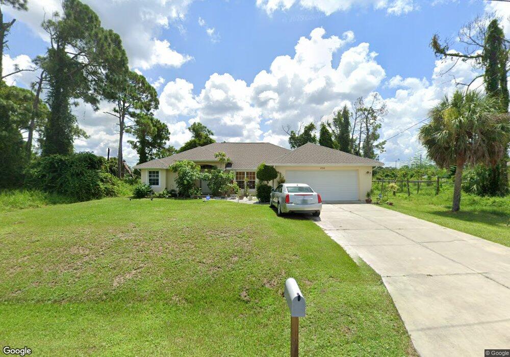
4926 Lovett Rd North Port, FL 34288
Estimated Value: $330,612 - $412,000
3
Beds
2
Baths
2,129
Sq Ft
$178/Sq Ft
Est. Value
About This Home
This home is located at 4926 Lovett Rd, North Port, FL 34288 and is currently estimated at $377,903, approximately $177 per square foot. 4926 Lovett Rd is a home located in Sarasota County with nearby schools including Atwater Elementary School, North Port High School, and Woodland Middle School.
Ownership History
Date
Name
Owned For
Owner Type
Purchase Details
Closed on
Nov 30, 2006
Sold by
Premier Homes Of South Florida Llc
Bought by
Lwin Tint and Aye Tin Ma
Current Estimated Value
Home Financials for this Owner
Home Financials are based on the most recent Mortgage that was taken out on this home.
Original Mortgage
$183,920
Outstanding Balance
$110,266
Interest Rate
6.36%
Mortgage Type
Purchase Money Mortgage
Estimated Equity
$267,637
Purchase Details
Closed on
Nov 6, 2003
Sold by
Saunders Stephen and Hamilton Catherine
Bought by
Premier Homes South Fl Corp
Create a Home Valuation Report for This Property
The Home Valuation Report is an in-depth analysis detailing your home's value as well as a comparison with similar homes in the area
Home Values in the Area
Average Home Value in this Area
Purchase History
| Date | Buyer | Sale Price | Title Company |
|---|---|---|---|
| Lwin Tint | $229,900 | Attorney | |
| Premier Homes South Fl Corp | $5,000 | -- |
Source: Public Records
Mortgage History
| Date | Status | Borrower | Loan Amount |
|---|---|---|---|
| Open | Lwin Tint | $183,920 |
Source: Public Records
Tax History Compared to Growth
Tax History
| Year | Tax Paid | Tax Assessment Tax Assessment Total Assessment is a certain percentage of the fair market value that is determined by local assessors to be the total taxable value of land and additions on the property. | Land | Improvement |
|---|---|---|---|---|
| 2024 | $2,040 | $137,630 | -- | -- |
| 2023 | $2,040 | $121,521 | $0 | $0 |
| 2022 | $2,182 | $130,082 | $0 | $0 |
| 2021 | $2,125 | $126,293 | $0 | $0 |
| 2020 | $2,100 | $124,549 | $0 | $0 |
| 2019 | $2,040 | $121,749 | $0 | $0 |
| 2018 | $1,889 | $119,479 | $0 | $0 |
| 2017 | $1,844 | $117,022 | $0 | $0 |
| 2016 | $1,834 | $169,700 | $5,800 | $163,900 |
| 2015 | $1,862 | $152,300 | $4,600 | $147,700 |
| 2014 | $1,826 | $111,246 | $0 | $0 |
Source: Public Records
Map
Nearby Homes
- 0 Pinson Dr
- 5122 Balmor Terrace
- 5153 Pinson Dr
- 1214 Rumson Ct
- Lot 24 -25 Balmor Terrace
- 5188 Balmor Terrace
- 0 Rumson Rd Unit MFRA4638802
- LOT 13 Rumson Ct
- 0 Balmor Terrace Unit MFRC7513411
- 5262 Weatherton St
- 5290 Weatherton St
- 0 Oakley Rd Unit MFRC7505026
- 0 Kenvil Dr Unit MFRC7505533
- 0 Kenvil Dr Unit MFRN6141208
- 4683 Oakley Rd
- 1212 Gillespie Ave
- LOT 7 Fernway Dr
- LOT 5 Fernway Dr
- LOT 2 Fernway Dr
- 5365 Ensley Terrace