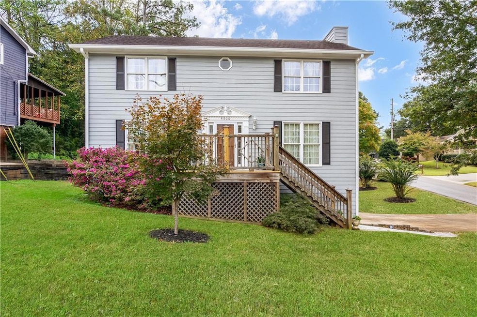
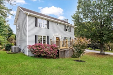
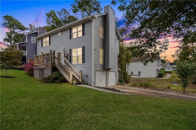
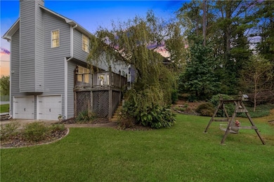
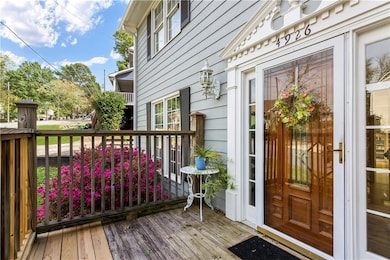
4926 Shallow Ridge Rd NE Kennesaw, GA 30144
Estimated payment $2,040/month
Highlights
- Deck
- Traditional Architecture
- Corner Lot
- McCleskey Middle School Rated A-
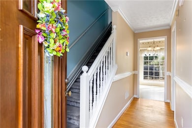
- Wood Flooring
- Community Pool
About This Home
Welcome to this spacious 3-bedroom, 2.5-bath home located in the sought-after Falcon Hills community. This beautiful residence offers a great layout with plenty of potential for those looking to add their own personal touch. Inside, you’ll find a comfortable main level featuring a bright kitchen with updated appliances. The family room centers around a cozy fireplace, perfect for relaxing evenings at home. Upstairs, all three bedrooms provide generous space, including a primary suite with an en-suite bath. Enjoy the gorgeous backyard with a beautiful patio overlooking peaceful views, ideal for morning coffee or weekend gatherings. The additional room in the basement can serve as an entertainment area, home office, or hobby space. The 2-car garage also provides a spacious storage area. There are endless possibilities at this beautiful home to make it your own.
Home Details
Home Type
- Single Family
Est. Annual Taxes
- $810
Year Built
- Built in 1990
Lot Details
- 6,983 Sq Ft Lot
- Corner Lot
- Back and Front Yard
HOA Fees
- $31 Monthly HOA Fees
Parking
- 2 Car Garage
- Driveway
Home Design
- Traditional Architecture
- Shingle Roof
Interior Spaces
- 1,762 Sq Ft Home
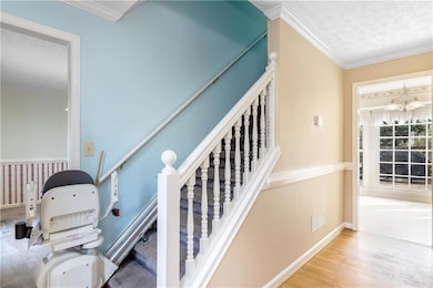
- 3-Story Property
- Electric Fireplace
- Family Room with Fireplace
- Formal Dining Room
- Finished Basement
- Stubbed For A Bathroom
- Fire and Smoke Detector
- Laundry in Garage
Kitchen
- Electric Oven
- Electric Cooktop
- Microwave
- Dishwasher
Flooring
- Wood
- Carpet
- Vinyl
Bedrooms and Bathrooms
- 3 Bedrooms
- Dual Vanity Sinks in Primary Bathroom
- Separate Shower in Primary Bathroom
Schools
- Blackwell - Cobb Elementary School
- Mccleskey Middle School
- Kell High School
Utilities
- Central Heating and Cooling System
- 110 Volts
- Cable TV Available
Additional Features
- Stair Lift
- Deck
Listing and Financial Details
- Assessor Parcel Number 16006600620
Community Details
Overview
- Falcon Hills Subdivision
Recreation
- Tennis Courts
- Community Playground
- Community Pool
Map
Home Values in the Area
Average Home Value in this Area
Tax History
| Year | Tax Paid | Tax Assessment Tax Assessment Total Assessment is a certain percentage of the fair market value that is determined by local assessors to be the total taxable value of land and additions on the property. | Land | Improvement |
|---|---|---|---|---|
| 2025 | $810 | $158,360 | $30,000 | $128,360 |
| 2024 | $814 | $158,360 | $30,000 | $128,360 |
| 2023 | $499 | $122,168 | $30,000 | $92,168 |
| 2022 | $651 | $104,092 | $18,000 | $86,092 |
| 2021 | $578 | $79,656 | $16,000 | $63,656 |
| 2020 | $561 | $73,804 | $14,000 | $59,804 |
| 2019 | $561 | $73,804 | $14,000 | $59,804 |
| 2018 | $561 | $73,804 | $14,000 | $59,804 |
| 2017 | $444 | $55,692 | $16,000 | $39,692 |
| 2016 | $445 | $55,692 | $16,000 | $39,692 |
| 2015 | $355 | $40,328 | $17,600 | $22,728 |
| 2014 | -- | $40,328 | $0 | $0 |
Property History
| Date | Event | Price | List to Sale | Price per Sq Ft |
|---|---|---|---|---|
| 10/24/2025 10/24/25 | For Sale | $370,000 | -- | $210 / Sq Ft |
Purchase History
| Date | Type | Sale Price | Title Company |
|---|---|---|---|
| Deed | $161,000 | -- | |
| Deed | $88,900 | -- | |
| Deed | $94,400 | -- |
Mortgage History
| Date | Status | Loan Amount | Loan Type |
|---|---|---|---|
| Closed | $35,420 | Stand Alone Refi Refinance Of Original Loan | |
| Closed | $0 | No Value Available |
Source: First Multiple Listing Service (FMLS)
MLS Number: 7670429
APN: 16-0066-0-062-0
![]() Listings identified with the FMLS IDX logo come from FMLS and are held by brokerage firms other than the owner of this website. The listing brokerage is identified in any listing details. Information is deemed reliable but is not guaranteed. If you believe any FMLS listing contains material that infringes your copyrighted work please visit www.fmls.com/dmca to review our DMCA policy and learn how to submit a takedown request. © 2025 First Multiple Listing Service, Inc.
Listings identified with the FMLS IDX logo come from FMLS and are held by brokerage firms other than the owner of this website. The listing brokerage is identified in any listing details. Information is deemed reliable but is not guaranteed. If you believe any FMLS listing contains material that infringes your copyrighted work please visit www.fmls.com/dmca to review our DMCA policy and learn how to submit a takedown request. © 2025 First Multiple Listing Service, Inc.
Disclaimer: Certain information contained herein is derived from information provided by parties other than Homes.com. All information provided is deemed reliable, but is not guaranteed to be accurate and should be independently verified.
- 1816 Yorkshire Dr
- 163 Castleair Ct NE
- 0 Lake Latimer Dr NE Unit 7564947
- 48 Lake Latimer Dr NE
- 46 Lake Latimer Dr NE
- 44 Lake Latimer Dr NE
- 0 Lake Latimer Dr NE Unit 10506857
- 2108 Yorkshire Ct
- 0 Watkins Glen Dr NE Unit 7564156
- 0 Watkins Glen Dr NE Unit 10506865
- 4978 Thornwood Cove NW
- 1502 Lake Koinonia Dr
- 4961 Thornwood Trace NW
- 4772 Stable Run Ct NE
- 221 Ellis Ln
- 414 Delancy Dr
- 209 Ellis Ln
- 4809 Shallow Farm Dr NE
- 333 Castleair Dr NE
- 95 Kestrel Ct NW Unit 1
- 4771 N Springs Rd NW
- 4620 Timrose Rd NW
- 900 View Dr
- 4621 Kings Crossing Dr NE
- 50 Downsby Ln
- 4678 N Springs Ln NW
- 434 Lanier Cir
- 338 Lanier Cir
- 215 Simpson Dr NE
- 326 Farm Place Ct NE
- 5141 Farm Place Dr NE
- 145 Townview Dr
- 639 Tigers Eye Terrace
- 4669 Blue Topaz Trail
- 5168 Legendary Ln
- 233 Bobbie Way
- 5246 Valley Tarn Unit 34
