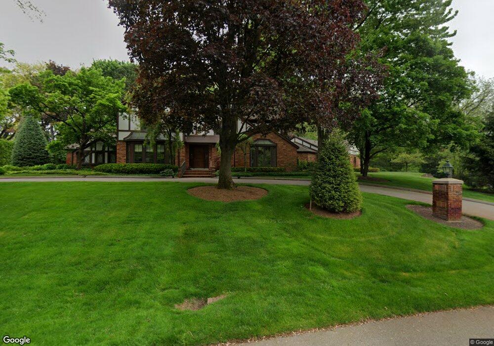
493 Dunston Rd Bloomfield Hills, MI 48304
Estimated Value: $2,716,961 - $3,187,000
5
Beds
7
Baths
7,458
Sq Ft
$400/Sq Ft
Est. Value
About This Home
This home is located at 493 Dunston Rd, Bloomfield Hills, MI 48304 and is currently estimated at $2,986,320, approximately $400 per square foot. 493 Dunston Rd is a home located in Oakland County with nearby schools including Quarton Elementary, Derby Middle School, and Ernest W. Seaholm High School.
Ownership History
Date
Name
Owned For
Owner Type
Purchase Details
Closed on
Jan 9, 2025
Sold by
Graham A Orley Revocable Trust and Orley Randall C
Bought by
Sally A Orley Revocable Trust and Orley
Current Estimated Value
Purchase Details
Closed on
Dec 31, 2007
Sold by
Orley Graham A and Orley Sally A
Bought by
Orley Graham A and Orley Sally A
Purchase Details
Closed on
Mar 18, 2004
Sold by
Orley Graham A
Bought by
Orley Graham A and Orley Sally A
Create a Home Valuation Report for This Property
The Home Valuation Report is an in-depth analysis detailing your home's value as well as a comparison with similar homes in the area
Home Values in the Area
Average Home Value in this Area
Purchase History
| Date | Buyer | Sale Price | Title Company |
|---|---|---|---|
| Sally A Orley Revocable Trust | -- | None Listed On Document | |
| Sally A Orley Revocable Trust | -- | None Listed On Document | |
| Orley Graham A | -- | None Available | |
| Orley Graham A | -- | -- |
Source: Public Records
Tax History Compared to Growth
Tax History
| Year | Tax Paid | Tax Assessment Tax Assessment Total Assessment is a certain percentage of the fair market value that is determined by local assessors to be the total taxable value of land and additions on the property. | Land | Improvement |
|---|---|---|---|---|
| 2024 | $21,490 | $977,320 | $0 | $0 |
| 2023 | $20,569 | $918,810 | $0 | $0 |
| 2022 | $22,213 | $907,980 | $0 | $0 |
| 2021 | $21,749 | $891,200 | $0 | $0 |
| 2020 | $19,405 | $843,310 | $0 | $0 |
| 2019 | $21,574 | $794,110 | $0 | $0 |
| 2018 | $21,357 | $778,510 | $0 | $0 |
| 2017 | $21,290 | $766,520 | $0 | $0 |
| 2016 | $21,307 | $738,380 | $0 | $0 |
| 2015 | -- | $702,600 | $0 | $0 |
| 2014 | -- | $599,390 | $0 | $0 |
| 2011 | -- | $514,940 | $0 | $0 |
Source: Public Records
Map
Nearby Homes
- 270 Martell Dr
- 375 Dunston Rd
- 596 Rudgate Rd
- 1019 N Cranbrook Rd
- 1260 Lyonhurst St
- 1348 Charrington Rd
- 1120 Lyonhurst St
- 956 Westwood Dr
- 2579 Amberly Rd
- 1287 Charrington Rd
- 692 Bennington Dr
- 1882 Melbourne St
- 1537 Ashford Ln
- 60 Kingsley Manor Dr
- 5825 Lahser Rd
- 3546 Bloomfield Club Dr
- 1056 Pilgrim Ave
- 33 Boulder Ln Unit 2
- 345 Kimberly St
- 1834 Fairview St
- 455 Doningham Ln
- 495 Dunston Rd
- 477 Dunston Rd
- 471 Dunston Rd
- 494 Dunston Rd
- 490 Dunston Rd
- 497 Dunston Rd
- 343 Doningham Ln
- 498 Dunston Rd
- 75 Quarton Ln
- 499 Dunston Rd
- 440 Dunston Rd
- 486 Dunston Ct
- 55 Quarton Ln
- 474 Dunston Rd
- 478 Dunston Rd
- 95 Quarton Ln
- 417 Dunston Rd
- 465 Haverhill Rd Unit Bldg-Unit
- 465 Haverhill Rd