
Seller's Agent in 2025
Rick Rano
RE/MAX
(614) 839-1633
4 in this area
299 Total Sales


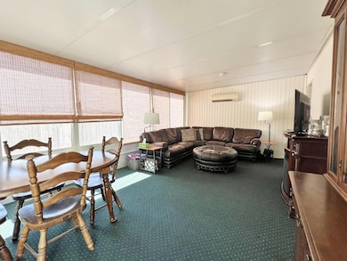
Opportunity Awaits! 3-Bedroom Ranch with Vaulted Living Room & Spacious 4-Season Room. This 3-bedroom, 1-bath ranch home offers a full basement and great potential for customization and updates. The Living Room features a vaulted ceiling and bay window (2015), creating a bright and open space. The Eat-In Kitchen includes a stainless steel refrigerator and smooth-top range, ready for your personal touch. A standout feature is the 20x13 Four-Season Room, heated and cooled by a Carrier Mini Split System, perfect for year-round enjoyment. The home also includes a 2-car attached garage and a full basement, offering ample storage and expansion possibilities. Comfort systems include an Atlas Butler Electric Heat Pump and A/C (2017) and a leased Sepco 115-gallon hot water tank. The concrete driveway (2022) adds curb appeal and durability. Outside, the large backyard with a mature shade tree, a cozy deck, and fire pit provides a great space for enjoying the great outdoors. While the home needs some TLC, it presents a great opportunity to build equity and make it your own. Centrally located near restaurants, grocery stores, shopping, and parks, this property combines convenience with potential. No flippers please, property priced at market value.
Last Agent to Sell the Property
RE/MAX Affiliates, Inc. License #2003001121 Listed on: 09/24/2025
| Date | Type | Sale Price | Title Company |
|---|---|---|---|
| Warranty Deed | $254,000 | Chicago Title | |
| Deed | $65,900 | -- | |
| Deed | -- | -- |
| Date | Status | Loan Amount | Loan Type |
|---|---|---|---|
| Open | $170,180 | New Conventional |
| Date | Event | Price | List to Sale | Price per Sq Ft |
|---|---|---|---|---|
| 10/31/2025 10/31/25 | Sold | $254,000 | +1.6% | $188 / Sq Ft |
| 10/30/2025 10/30/25 | Pending | -- | -- | -- |
| 09/24/2025 09/24/25 | For Sale | $250,000 | -- | $185 / Sq Ft |
| Year | Tax Paid | Tax Assessment Tax Assessment Total Assessment is a certain percentage of the fair market value that is determined by local assessors to be the total taxable value of land and additions on the property. | Land | Improvement |
|---|---|---|---|---|
| 2024 | $2,719 | $70,390 | $19,950 | $50,440 |
| 2023 | $2,712 | $70,390 | $19,950 | $50,440 |
| 2022 | $1,966 | $46,660 | $10,500 | $36,160 |
| 2021 | $1,970 | $46,660 | $10,500 | $36,160 |
| 2020 | $1,972 | $46,660 | $10,500 | $36,160 |
| 2019 | $1,769 | $37,910 | $8,400 | $29,510 |
| 2018 | $1,632 | $37,910 | $8,400 | $29,510 |
| 2017 | $1,710 | $37,910 | $8,400 | $29,510 |
| 2016 | $1,651 | $33,680 | $7,880 | $25,800 |
| 2015 | $1,499 | $33,680 | $7,880 | $25,800 |
| 2014 | $1,503 | $33,680 | $7,880 | $25,800 |
| 2013 | $794 | $35,455 | $8,295 | $27,160 |
Seller's Agent in 2025
Rick Rano
RE/MAX
(614) 839-1633
4 in this area
299 Total Sales
N
Buyer's Agent in 2025
Na'Tera Toles
Take A Look RealEstate Brokers
(614) 327-9706
1 in this area
12 Total Sales
Buyer Co-Listing Agent in 2025
Theresa Barron
Take A Look RealEstate Brokers
(614) 778-8503
1 in this area
86 Total Sales
Source: Columbus and Central Ohio Regional MLS
MLS Number: 225036172
APN: 010-145070
Disclaimer: Certain information contained herein is derived from information provided by parties other than Homes.com. All information provided is deemed reliable, but is not guaranteed to be accurate and should be independently verified.
![]() IDX information is provided exclusively for personal, non-commercial use, and may not be used for any purpose other than to identify prospective properties consumers may be interested in purchasing.
IDX information is provided exclusively for personal, non-commercial use, and may not be used for any purpose other than to identify prospective properties consumers may be interested in purchasing.
Information is deemed reliable but not guaranteed.