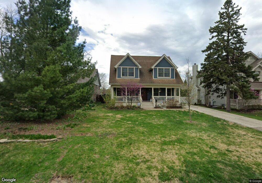
4930 Pershing Ave Downers Grove, IL 60515
Estimated Value: $542,000 - $689,325
Studio
--
Bath
1,973
Sq Ft
$318/Sq Ft
Est. Value
About This Home
This home is located at 4930 Pershing Ave, Downers Grove, IL 60515 and is currently estimated at $627,581, approximately $318 per square foot. 4930 Pershing Ave is a home located in DuPage County with nearby schools including Henry Puffer School, Herrick Middle School, and Downer Grove North High School.
Ownership History
Date
Name
Owned For
Owner Type
Purchase Details
Closed on
Sep 12, 1996
Sold by
Ushela George and Ushela George A
Bought by
Woods Michael J and Woods Jennifer L
Current Estimated Value
Home Financials for this Owner
Home Financials are based on the most recent Mortgage that was taken out on this home.
Original Mortgage
$137,000
Outstanding Balance
$11,484
Interest Rate
7.93%
Estimated Equity
$616,097
Create a Home Valuation Report for This Property
The Home Valuation Report is an in-depth analysis detailing your home's value as well as a comparison with similar homes in the area
Home Values in the Area
Average Home Value in this Area
Purchase History
| Date | Buyer | Sale Price | Title Company |
|---|---|---|---|
| Woods Michael J | $142,000 | First American Title |
Source: Public Records
Mortgage History
| Date | Status | Borrower | Loan Amount |
|---|---|---|---|
| Open | Woods Michael J | $137,000 |
Source: Public Records
Tax History
| Year | Tax Paid | Tax Assessment Tax Assessment Total Assessment is a certain percentage of the fair market value that is determined by local assessors to be the total taxable value of land and additions on the property. | Land | Improvement |
|---|---|---|---|---|
| 2024 | $10,674 | $194,629 | $60,548 | $134,081 |
| 2023 | $10,103 | $177,630 | $55,260 | $122,370 |
| 2022 | $10,101 | $177,630 | $55,260 | $122,370 |
| 2021 | $9,210 | $170,910 | $53,170 | $117,740 |
| 2020 | $9,061 | $167,830 | $52,210 | $115,620 |
| 2019 | $8,757 | $160,570 | $49,950 | $110,620 |
| 2018 | $8,419 | $152,490 | $47,440 | $105,050 |
| 2017 | $8,191 | $147,350 | $45,840 | $101,510 |
| 2016 | $8,081 | $142,020 | $44,180 | $97,840 |
| 2015 | $8,003 | $133,740 | $41,600 | $92,140 |
| 2014 | $7,936 | $128,930 | $40,100 | $88,830 |
| 2013 | $7,833 | $129,240 | $40,200 | $89,040 |
Source: Public Records
Map
Nearby Homes
- 4817 Belmont Rd
- 4947 Stonewall Ave
- 1953 Wisconsin Ave
- 4904 Rose Ave
- 1950 Elmore Ave
- 4640 Stonewall Ave
- 5237 Cornell Ave
- 4620 Stonewall Ave
- 4836 Francisco Ave
- 4908 Cross St
- 2160 Howard Ave
- 5513 Aspen Ave
- 4425 Wilson Ave
- 2419 Ogden Ave Unit 9
- 4407 Pershing Ave Unit 2S
- 2319 Chasewood Dr
- 4436 Lee Ave
- 1903 Maple Ave
- 5622 Belmont Rd
- 411 Provence Ct
- 4926 Pershing Ave
- 4934 Pershing Ave
- 4938 Pershing Ave
- 4922 Pershing Ave
- 2100 Warren Ave Unit 2100
- 2102 Warren Ave Unit 2102
- 2106 Warren Ave Unit 2106
- 4935 Pershing Ave
- 2110 Warren Ave Unit 2110
- 4939 Pershing Ave
- 2112 Warren Ave Unit 2112
- 4918 Pershing Ave
- 2104 Warren Ave Unit 2104
- 4923 Pershing Ave
- 2114 Warren Ave Unit 214
- 2108 Warren Ave Unit 2108
- 4919 Pershing Ave
- 4914 Pershing Ave
- 2118 Warren Ave Unit 2118
- 2119 Warren Ave
Your Personal Tour Guide
Ask me questions while you tour the home.