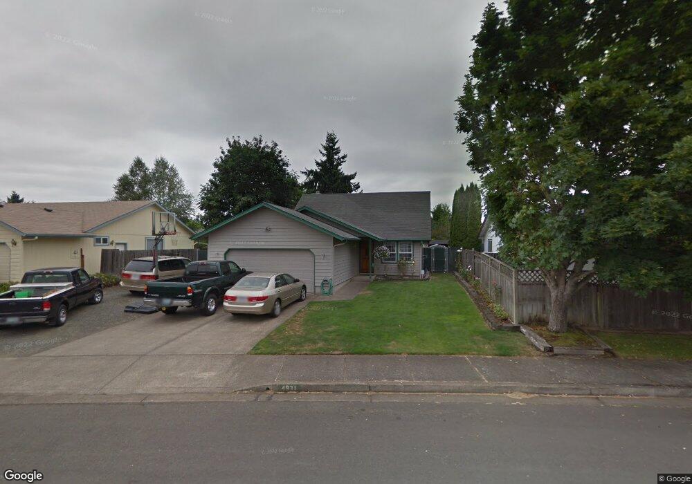
4931 Parsons Ave Eugene, OR 97402
Bethel NeighborhoodEstimated Value: $383,833 - $412,000
3
Beds
2
Baths
1,254
Sq Ft
$319/Sq Ft
Est. Value
About This Home
This home is located at 4931 Parsons Ave, Eugene, OR 97402 and is currently estimated at $399,958, approximately $318 per square foot. 4931 Parsons Ave is a home located in Lane County with nearby schools including Prairie Mountain School and Willamette High School.
Ownership History
Date
Name
Owned For
Owner Type
Purchase Details
Closed on
Sep 26, 2024
Sold by
Mortensen Greg T and Mortensen Tricia L
Bought by
Mortensen Family Revocable Trust and Mortensen
Current Estimated Value
Create a Home Valuation Report for This Property
The Home Valuation Report is an in-depth analysis detailing your home's value as well as a comparison with similar homes in the area
Home Values in the Area
Average Home Value in this Area
Purchase History
| Date | Buyer | Sale Price | Title Company |
|---|---|---|---|
| Mortensen Family Revocable Trust | -- | None Listed On Document | |
| Mortensen Family Revocable Trust | -- | None Listed On Document |
Source: Public Records
Tax History
| Year | Tax Paid | Tax Assessment Tax Assessment Total Assessment is a certain percentage of the fair market value that is determined by local assessors to be the total taxable value of land and additions on the property. | Land | Improvement |
|---|---|---|---|---|
| 2025 | $3,692 | $212,277 | -- | -- |
| 2024 | $3,599 | $206,095 | -- | -- |
| 2023 | $3,599 | $200,093 | $0 | $0 |
| 2022 | $3,351 | $194,266 | $0 | $0 |
| 2021 | $3,280 | $188,608 | $0 | $0 |
| 2020 | $3,184 | $183,115 | $0 | $0 |
| 2019 | $3,028 | $177,782 | $0 | $0 |
| 2018 | $2,943 | $167,577 | $0 | $0 |
| 2017 | $2,813 | $167,577 | $0 | $0 |
| 2016 | $2,741 | $162,696 | $0 | $0 |
| 2015 | $2,687 | $157,957 | $0 | $0 |
| 2014 | $2,646 | $153,356 | $0 | $0 |
Source: Public Records
Map
Nearby Homes
- 4985 Cone Ave
- 4900 Royal Ave Unit 105
- 4900 Royal Ave Unit SP13
- 536 Raber Rd
- 654 Saint Charles St
- 647 Oakwood Dr
- 5260 Forest Ln
- 639 Oakwood Dr
- 648 Oakwood Dr
- 671 Saint Charles St
- 683 Saint Charles St
- 658 Saint Charles St
- 5254 Forest Ln
- 664 Saint Charles St
- 670 Saint Charles St
- 715 St Charles St
- 723 St Charles St
- 735 St Charles St
- 5275 Forest Ln
- 749 St Charles St
- 4933 Parsons Ave
- 4929 Parsons Ave
- 4932 Cone Ave
- 4927 Parsons Ave
- 4930 Cone Ave
- 4935 Parsons Ave
- 4947 Parsons Ave
- 4934 Cone Ave
- 4925 Parsons Ave
- 4949 Parsons Ave
- 4945 Parsons Ave
- 4937 Parsons Ave
- 4928 Cone Ave
- 4943 Parsons Ave
- 4930 Parsons Ave
- 4928 Parsons Ave
- 4940 Parsons Ave
- 4923 Parsons Ave
- 4940 Cone Ave
- 4953 Parsons Ave
Your Personal Tour Guide
Ask me questions while you tour the home.