Estimated Value: $65,000 - $91,910
--
Bed
--
Bath
908
Sq Ft
$86/Sq Ft
Est. Value
About This Home
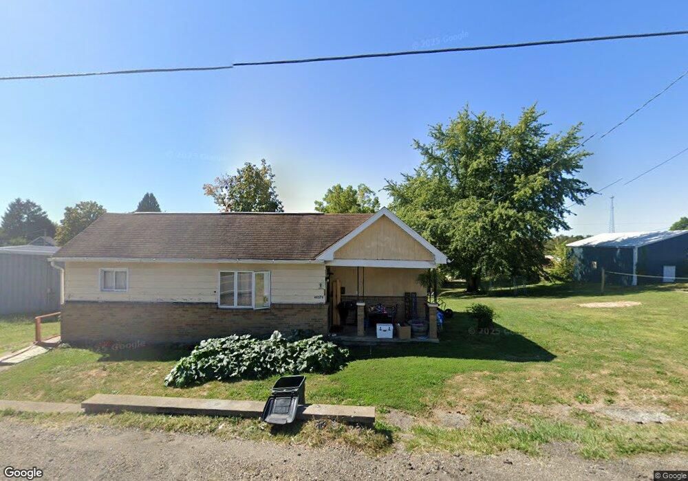
This home is located at 49379 U S Route 250 Rd, Adena, OH 43901 and is currently estimated at $78,228, approximately $86 per square foot. 49379 U S Route 250 Rd is a home with nearby schools including Buckeye Local High School.
Ownership History
Date
Name
Owned For
Owner Type
Purchase Details
Closed on
Oct 17, 2018
Sold by
Stemkowski Stanley J and Duill Bonnie L
Bought by
Duill Daniel
Current Estimated Value
Home Financials for this Owner
Home Financials are based on the most recent Mortgage that was taken out on this home.
Original Mortgage
$15,600
Outstanding Balance
$5,593
Interest Rate
4.6%
Mortgage Type
Commercial
Estimated Equity
$72,635
Purchase Details
Closed on
Nov 2, 1992
Purchase Details
Closed on
Dec 24, 1991
Create a Home Valuation Report for This Property
The Home Valuation Report is an in-depth analysis detailing your home's value as well as a comparison with similar homes in the area
Home Values in the Area
Average Home Value in this Area
Purchase History
| Date | Buyer | Sale Price | Title Company |
|---|---|---|---|
| Duill Daniel | $19,500 | None Available | |
| -- | -- | -- | |
| -- | -- | -- |
Source: Public Records
Mortgage History
| Date | Status | Borrower | Loan Amount |
|---|---|---|---|
| Open | Duill Daniel | $15,600 |
Source: Public Records
Tax History Compared to Growth
Tax History
| Year | Tax Paid | Tax Assessment Tax Assessment Total Assessment is a certain percentage of the fair market value that is determined by local assessors to be the total taxable value of land and additions on the property. | Land | Improvement |
|---|---|---|---|---|
| 2024 | $784 | $20,200 | $4,160 | $16,040 |
| 2023 | $743 | $20,200 | $4,160 | $16,040 |
| 2022 | $265 | $15,790 | $3,470 | $12,320 |
| 2021 | $263 | $15,790 | $3,470 | $12,320 |
| 2020 | $262 | $15,790 | $3,470 | $12,320 |
| 2019 | $204 | $14,090 | $3,090 | $11,000 |
| 2018 | $206 | $14,090 | $3,090 | $11,000 |
| 2017 | $201 | $14,090 | $3,090 | $11,000 |
| 2016 | $190 | $13,720 | $2,870 | $10,850 |
| 2015 | $521 | $13,720 | $2,870 | $10,850 |
| 2014 | $162 | $13,150 | $2,610 | $10,540 |
| 2013 | $162 | $13,150 | $2,610 | $10,540 |
Source: Public Records
Map
Nearby Homes
- 303 County Road 71
- 1749 Us 250
- 1281 Township Road 129
- 572 W Main St
- 113 Roby St
- 101 Lyons St
- 332 Township Road 153
- 425 Blairmont Rd
- 103 Horeshoe Alley
- 75601 16th Rd
- 0 Terra Ridge Ln
- 49770 Fairpoint Maynard Rd
- 49991 Purseglove Rd
- 49659 Water St
- 543 Union St
- 148 Oak Dr
- 0 North St Unit 5148451
- 0 Ohio 647
- 73881 Colerain Mount Pleasant Rd
- 48837 Hillcrest Dr
- 49358 Main St
- 49377 Main St
- 49377 Harrisville Rd
- 49515 Cherry St
- 49394 U S Route 250
- 49400 E Main St
- 49517 Cherry St
- 49398 Cherry St
- 49513 Cherry St
- 49511 Green St
- 49479 Green St
- 49481 Green St
- 49371 U S Route 250 Rd
- 49402 U S Route 250
- 49509 Green St
- 49385 Wheeling Rd
- 49485 Green St
- 49392 Main St
- 49404 U S Route 250 Rd
- 49390 E Main St