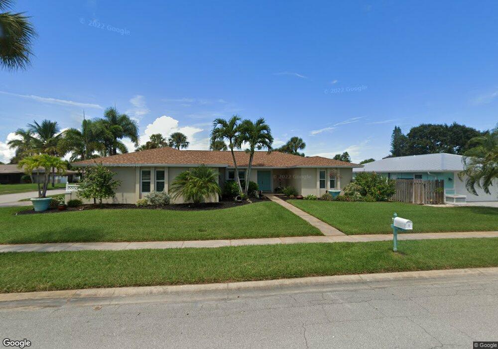
495 E Amherst Cir Satellite Beach, FL 32937
Estimated Value: $630,132 - $710,000
3
Beds
2
Baths
2,212
Sq Ft
$299/Sq Ft
Est. Value
About This Home
This home is located at 495 E Amherst Cir, Satellite Beach, FL 32937 and is currently estimated at $661,533, approximately $299 per square foot. 495 E Amherst Cir is a home located in Brevard County with nearby schools including Surfside Elementary School, Satellite Senior High School, and DeLaura Middle School.
Ownership History
Date
Name
Owned For
Owner Type
Purchase Details
Closed on
Sep 15, 2009
Sold by
Burnette Shirley Faye and Sigmon Shirley B
Bought by
Burnette Shirley Faye and Ronan Melissa
Current Estimated Value
Create a Home Valuation Report for This Property
The Home Valuation Report is an in-depth analysis detailing your home's value as well as a comparison with similar homes in the area
Home Values in the Area
Average Home Value in this Area
Purchase History
| Date | Buyer | Sale Price | Title Company |
|---|---|---|---|
| Burnette Shirley Faye | -- | Attorney |
Source: Public Records
Tax History
| Year | Tax Paid | Tax Assessment Tax Assessment Total Assessment is a certain percentage of the fair market value that is determined by local assessors to be the total taxable value of land and additions on the property. | Land | Improvement |
|---|---|---|---|---|
| 2025 | $2,989 | $196,330 | -- | -- |
| 2024 | $2,940 | $190,800 | -- | -- |
| 2023 | $2,940 | $185,250 | $0 | $0 |
| 2022 | $2,754 | $179,860 | $0 | $0 |
| 2021 | $2,836 | $174,630 | $0 | $0 |
| 2020 | $2,826 | $172,220 | $0 | $0 |
| 2019 | $2,806 | $168,350 | $0 | $0 |
| 2018 | $2,807 | $165,220 | $0 | $0 |
| 2017 | $2,632 | $161,830 | $0 | $0 |
| 2016 | $2,639 | $158,510 | $85,000 | $73,510 |
| 2015 | $2,703 | $157,410 | $75,000 | $82,410 |
| 2014 | $2,706 | $156,170 | $70,000 | $86,170 |
Source: Public Records
Map
Nearby Homes
- 509 W Amherst Cir
- 435 Desoto Pkwy
- 405 Hawthorne Ct
- 445 Saint Johns Dr
- 458 Saint Johns Dr
- 358 Desoto Pkwy
- 380 Cherry Ct
- 400 Maria Dr
- 647 Desoto Ln
- 550 Temple St
- 524 Mcguire Blvd
- 485 Temple St
- 413 Trinidad Dr
- 115 Island View Dr
- 368 Ocean Spray Ave
- 366 Ocean Spray Ave
- 240 Greenway Ave
- 360 Cassia Blvd
- 484 Greenway Ave
- 165 Island View Dr
- 485 E Amherst Cir
- 439 Winchester Rd
- 435 Winchester Rd
- 599 W Amherst Cir
- 490 E Amherst Cir
- 475 E Amherst Cir
- 445 Winchester Rd
- 480 E Amherst Cir
- 429 Winchester Rd
- 598 W Amherst Cir
- 589 W Amherst Cir
- 465 E Amherst Cir
- 470 E Amherst Cir
- 449 Winchester Rd
- 400 E Amherst Cir
- 425 Winchester Rd
- 588 W Amherst Cir
- 406 E Amherst Cir
- 440 Winchester Rd
- 438 Winchester Rd
Your Personal Tour Guide
Ask me questions while you tour the home.