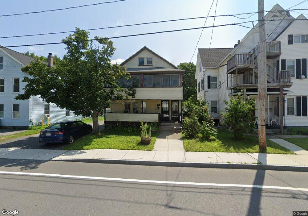
495 High St Unit 497 Clinton, MA 01510
Estimated Value: $449,112 - $669,000
6
Beds
2
Baths
2,436
Sq Ft
$234/Sq Ft
Est. Value
About This Home
This home is located at 495 High St Unit 497, Clinton, MA 01510 and is currently estimated at $570,528, approximately $234 per square foot. 495 High St Unit 497 is a home located in Worcester County with nearby schools including Clinton Elementary School, Clinton Senior High School, and Clinton Middle School.
Ownership History
Date
Name
Owned For
Owner Type
Purchase Details
Closed on
Jun 15, 1983
Bought by
Fintzel Vito
Current Estimated Value
Create a Home Valuation Report for This Property
The Home Valuation Report is an in-depth analysis detailing your home's value as well as a comparison with similar homes in the area
Home Values in the Area
Average Home Value in this Area
Purchase History
| Date | Buyer | Sale Price | Title Company |
|---|---|---|---|
| Fintzel Vito | $53,000 | -- |
Source: Public Records
Mortgage History
| Date | Status | Borrower | Loan Amount |
|---|---|---|---|
| Open | Fintzel Vito | $17,000 | |
| Open | Fintzel Vito | $63,000 | |
| Closed | Fintzel Vito | $15,000 |
Source: Public Records
Tax History Compared to Growth
Tax History
| Year | Tax Paid | Tax Assessment Tax Assessment Total Assessment is a certain percentage of the fair market value that is determined by local assessors to be the total taxable value of land and additions on the property. | Land | Improvement |
|---|---|---|---|---|
| 2025 | $5,590 | $420,300 | $80,000 | $340,300 |
| 2024 | $5,206 | $396,200 | $80,000 | $316,200 |
| 2023 | $4,908 | $367,100 | $72,800 | $294,300 |
| 2022 | $4,882 | $327,400 | $66,100 | $261,300 |
| 2021 | $4,369 | $274,100 | $63,000 | $211,100 |
| 2020 | $4,150 | $267,900 | $63,000 | $204,900 |
| 2019 | $3,876 | $243,300 | $61,100 | $182,200 |
| 2018 | $3,654 | $215,200 | $68,800 | $146,400 |
| 2017 | $3,356 | $189,900 | $57,300 | $132,600 |
| 2016 | $3,280 | $189,900 | $57,300 | $132,600 |
| 2015 | $2,987 | $179,300 | $55,700 | $123,600 |
| 2014 | $2,896 | $179,300 | $55,700 | $123,600 |
Source: Public Records
Map
Nearby Homes
- 119 Clark St
- 57 Clark St
- 6 Worcester St
- 55 Sterling St Unit 306
- 55 Sterling St Unit 314
- 116-118 Lawrence St
- 89 1/2 Walnut St
- 24 Rigby St
- 8 John F. Kennedy Ave
- 248 Greeley St
- 516 Ridgefield Cir Unit C
- 12 Woodruff Rd
- 51 Rigby St
- 38 Norman St
- 403 Main St
- 200 Ridgefield Cir Unit C
- 19 Magnolia Ave
- 525 Water St
- 1105 Ridgefield Cir Unit B
- 346 Oak St
- 495 High St Unit 2
- 495497 High St
- 491 High St Unit 3
- 491 High St Unit 2
- 499 High St
- 499 High St Unit 2
- 500 High St
- 492 High St Unit 494
- 492 High St Unit 2
- 492 High St Unit EXTENSIO
- 232 East St
- 483 High St
- 509 High St
- 509 High St Unit 2
- 214 East St
- 202 East St
- 202 East St Unit 2
- 479 High St
- 479 High St Unit 2
- 479 High Jstreet Unit 2