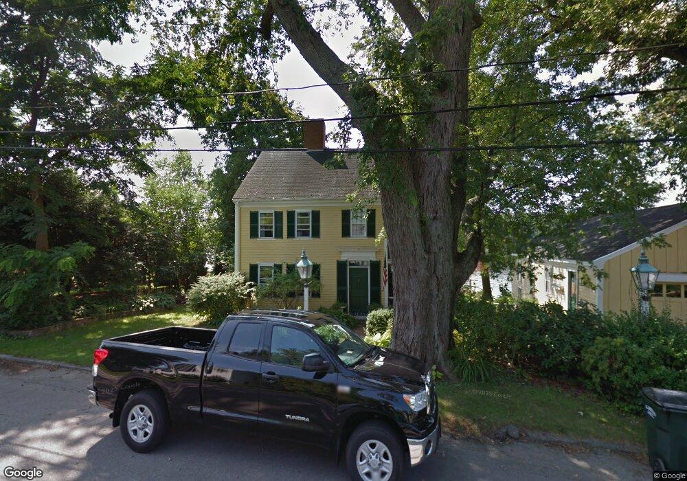
495 Main St Unit none Amesbury, MA 01913
Estimated Value: $1,446,111 - $1,928,000
2
Beds
2
Baths
2,040
Sq Ft
$793/Sq Ft
Est. Value
About This Home
This home is located at 495 Main St Unit none, Amesbury, MA 01913 and is currently estimated at $1,617,028, approximately $792 per square foot. 495 Main St Unit none is a home located in Essex County with nearby schools including Amesbury High School and River Valley Charter School.
Ownership History
Date
Name
Owned For
Owner Type
Purchase Details
Closed on
Jun 18, 2018
Sold by
Cullen Charles R
Bought by
Charles R Cullen T
Current Estimated Value
Purchase Details
Closed on
Aug 30, 2013
Sold by
Benting Jane T and Benting Allen
Bought by
Cullen Charles R
Home Financials for this Owner
Home Financials are based on the most recent Mortgage that was taken out on this home.
Original Mortgage
$500,000
Interest Rate
3%
Mortgage Type
Adjustable Rate Mortgage/ARM
Purchase Details
Closed on
Aug 28, 2008
Sold by
Benting Jane T
Bought by
Benting Jane T
Home Financials for this Owner
Home Financials are based on the most recent Mortgage that was taken out on this home.
Original Mortgage
$375,000
Interest Rate
6.29%
Purchase Details
Closed on
Apr 5, 2004
Sold by
Benting Jane T Ex and Jarvis Jane T Ex
Bought by
Benting Jane T
Create a Home Valuation Report for This Property
The Home Valuation Report is an in-depth analysis detailing your home's value as well as a comparison with similar homes in the area
Home Values in the Area
Average Home Value in this Area
Purchase History
| Date | Buyer | Sale Price | Title Company |
|---|---|---|---|
| Charles R Cullen T | -- | -- | |
| Cullen Charles R | $750,000 | -- | |
| Benting Jane T | -- | -- | |
| Benting Jane T | -- | -- |
Source: Public Records
Mortgage History
| Date | Status | Borrower | Loan Amount |
|---|---|---|---|
| Previous Owner | Benting Jane T | $500,000 | |
| Previous Owner | Benting Jane T | $250,000 | |
| Previous Owner | Benting Jane T | $375,000 | |
| Previous Owner | Benting Jane T | $375,000 |
Source: Public Records
Tax History Compared to Growth
Tax History
| Year | Tax Paid | Tax Assessment Tax Assessment Total Assessment is a certain percentage of the fair market value that is determined by local assessors to be the total taxable value of land and additions on the property. | Land | Improvement |
|---|---|---|---|---|
| 2025 | $19,549 | $1,277,700 | $809,700 | $468,000 |
| 2024 | $17,723 | $1,133,200 | $700,100 | $433,100 |
| 2023 | $16,543 | $1,012,400 | $578,500 | $433,900 |
| 2022 | $14,962 | $845,800 | $486,000 | $359,800 |
| 2021 | $15,916 | $872,100 | $486,000 | $386,100 |
| 2020 | $14,727 | $857,200 | $486,000 | $371,200 |
| 2019 | $13,834 | $753,100 | $419,000 | $334,100 |
| 2018 | $13,439 | $707,700 | $399,200 | $308,500 |
| 2017 | $12,179 | $610,500 | $346,700 | $263,800 |
| 2016 | $11,160 | $550,300 | $346,700 | $203,600 |
| 2015 | $11,071 | $539,000 | $346,700 | $192,300 |
| 2014 | $10,644 | $507,600 | $336,200 | $171,400 |
Source: Public Records
Map
Nearby Homes
- 18 Hawkswood Estates
- 486 Main St
- 473 Main St
- 435 Main St
- 2 Birchwood Ct Unit 101
- 25 Clarks Rd Unit 307
- 434 Main St
- 394 Main St
- 356 Main St
- 30 Dorothy e Lucey Dr
- 8 Brown Ave
- 47 Macy St
- 35 Merrimac St
- 510 Merrimac St Unit 512
- 45 Macy St Unit 302C
- 60 Merrimac St Unit 907
- 60 Merrimac St Unit 604
- 60 Merrimac St Unit 508
- 6 Boyd Dr
- 191 Elm St