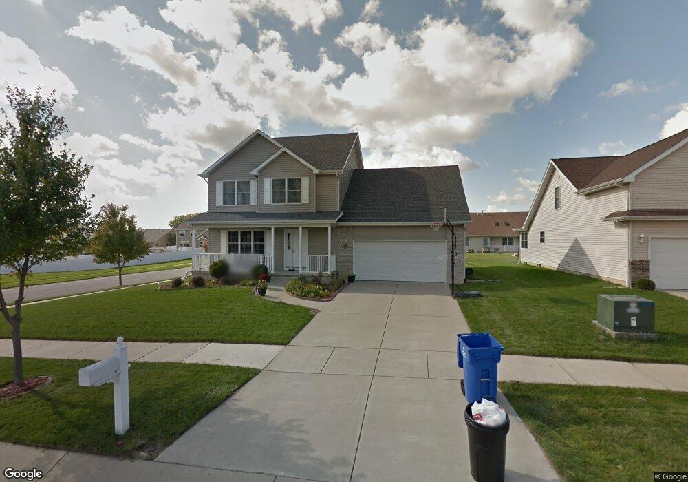
495 Quentin Ln Crown Point, IN 46307
Estimated Value: $415,000 - $513,000
3
Beds
3
Baths
2,527
Sq Ft
$176/Sq Ft
Est. Value
About This Home
This home is located at 495 Quentin Ln, Crown Point, IN 46307 and is currently estimated at $445,923, approximately $176 per square foot. 495 Quentin Ln is a home located in Lake County with nearby schools including Solon Robinson Elementary School, Colonel John Wheeler Middle School, and Crown Point High School.
Ownership History
Date
Name
Owned For
Owner Type
Purchase Details
Closed on
Nov 8, 2005
Sold by
F & H Properties Ii Inc
Bought by
Payne Justin T and Payne Theresa M
Current Estimated Value
Home Financials for this Owner
Home Financials are based on the most recent Mortgage that was taken out on this home.
Original Mortgage
$179,000
Outstanding Balance
$99,034
Interest Rate
6.2%
Mortgage Type
Fannie Mae Freddie Mac
Estimated Equity
$346,889
Create a Home Valuation Report for This Property
The Home Valuation Report is an in-depth analysis detailing your home's value as well as a comparison with similar homes in the area
Home Values in the Area
Average Home Value in this Area
Purchase History
| Date | Buyer | Sale Price | Title Company |
|---|---|---|---|
| Payne Justin T | -- | Ticor | |
| Stojova Vaska | -- | Ticor |
Source: Public Records
Mortgage History
| Date | Status | Borrower | Loan Amount |
|---|---|---|---|
| Open | Payne Justin T | $179,000 |
Source: Public Records
Tax History Compared to Growth
Tax History
| Year | Tax Paid | Tax Assessment Tax Assessment Total Assessment is a certain percentage of the fair market value that is determined by local assessors to be the total taxable value of land and additions on the property. | Land | Improvement |
|---|---|---|---|---|
| 2024 | $8,800 | $349,200 | $58,900 | $290,300 |
| 2023 | $3,326 | $320,200 | $58,900 | $261,300 |
| 2022 | $3,326 | $298,600 | $58,900 | $239,700 |
| 2021 | $3,216 | $288,900 | $39,300 | $249,600 |
| 2020 | $3,079 | $276,900 | $39,300 | $237,600 |
| 2019 | $3,080 | $273,000 | $39,300 | $233,700 |
| 2018 | $3,595 | $263,800 | $39,300 | $224,500 |
| 2017 | $3,577 | $260,200 | $39,300 | $220,900 |
| 2016 | $3,419 | $247,300 | $39,300 | $208,000 |
| 2014 | $3,217 | $248,800 | $39,300 | $209,500 |
| 2013 | $3,189 | $244,700 | $39,300 | $205,400 |
Source: Public Records
Map
Nearby Homes
- 4525 W 113th Ave
- 1593 Edith Way
- 1639 Fir Ave
- 1816 Elderberry Ct
- 11664 Broadway
- 508 W 117th Place
- 1746 Chestnut Dr
- 11442 Maryland Dr
- 206 U S 231
- 1710 Beech Dr
- 11514 Georgia Place
- 11732 Virginia Ct
- 10935-11005 Delaware Pkwy
- 970 E 114th Place
- 922 E 115th Place
- 11522 Vermont St
- 936 Seneca Dr
- 1270 E Greenview Place
- 1285 Greenview Place
- 1078 E 114th Ave
- 479 Quentin Ln
- 496 S Madison St
- 463 Quentin Ln
- 480 S Madison St
- 1805 Chessington Cir
- 496 Quentin Ln
- 464 S Madison St
- 484 Quentin Ln
- 447 Quentin Ln
- 500 S Madison St
- 470 Quentin Ln
- 448 S Madison St
- 1807 Chessington Cir
- 456 Quentin Ln
- 431 Quentin Ln
- 432 S Madison St
- 506 S Madison St
- 442 Quentin Ln
- 495 Krinbill Ln
- 485 Krinbill Ln