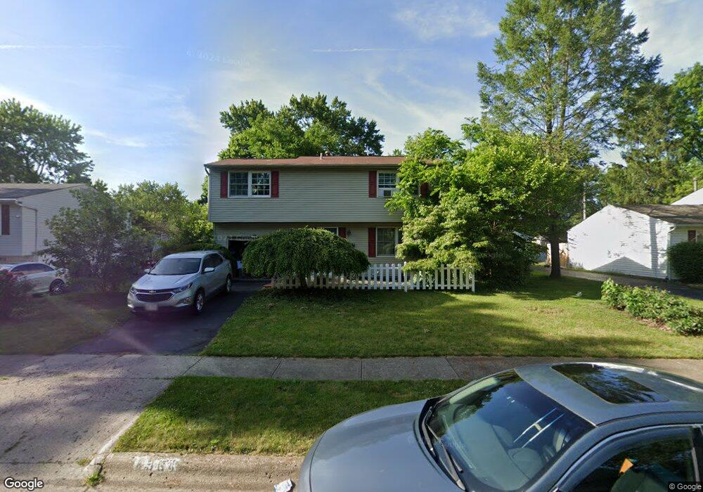
4964 Brewster Dr Columbus, OH 43232
East Columbus-White Ash NeighborhoodEstimated Value: $168,000 - $234,000
4
Beds
2
Baths
1,392
Sq Ft
$151/Sq Ft
Est. Value
About This Home
This home is located at 4964 Brewster Dr, Columbus, OH 43232 and is currently estimated at $210,200, approximately $151 per square foot. 4964 Brewster Dr is a home located in Franklin County with nearby schools including Groveport Madison High School, Eastland Preparatory Academy, and Capital City Career Prep High School.
Ownership History
Date
Name
Owned For
Owner Type
Purchase Details
Closed on
Oct 28, 2020
Sold by
Delong Annette and Delong Carol A
Bought by
Farkas Llc
Current Estimated Value
Purchase Details
Closed on
Aug 20, 1999
Sold by
Delong Jack E and Delong Anna K
Bought by
Delong Annette
Home Financials for this Owner
Home Financials are based on the most recent Mortgage that was taken out on this home.
Original Mortgage
$72,000
Interest Rate
7.61%
Purchase Details
Closed on
Aug 27, 1974
Bought by
Delong Jack E
Create a Home Valuation Report for This Property
The Home Valuation Report is an in-depth analysis detailing your home's value as well as a comparison with similar homes in the area
Home Values in the Area
Average Home Value in this Area
Purchase History
| Date | Buyer | Sale Price | Title Company |
|---|---|---|---|
| Farkas Llc | $110,000 | World Class Title | |
| Delong Annette | $100,000 | Foundation Title Agency Inc | |
| Delong Jack E | -- | -- |
Source: Public Records
Mortgage History
| Date | Status | Borrower | Loan Amount |
|---|---|---|---|
| Previous Owner | Delong Annette | $72,000 |
Source: Public Records
Tax History Compared to Growth
Tax History
| Year | Tax Paid | Tax Assessment Tax Assessment Total Assessment is a certain percentage of the fair market value that is determined by local assessors to be the total taxable value of land and additions on the property. | Land | Improvement |
|---|---|---|---|---|
| 2024 | $3,601 | $56,010 | $14,460 | $41,550 |
| 2023 | $3,570 | $73,045 | $14,455 | $58,590 |
| 2022 | $2,340 | $38,090 | $6,830 | $31,260 |
| 2021 | $2,348 | $38,090 | $6,830 | $31,260 |
| 2020 | $1,773 | $38,090 | $6,830 | $31,260 |
| 2019 | $1,598 | $32,030 | $5,710 | $26,320 |
| 2018 | $1,547 | $32,030 | $5,710 | $26,320 |
| 2017 | $1,611 | $32,030 | $5,710 | $26,320 |
| 2016 | $1,473 | $28,070 | $4,270 | $23,800 |
| 2015 | $1,486 | $28,070 | $4,270 | $23,800 |
| 2014 | $1,398 | $28,070 | $4,270 | $23,800 |
| 2013 | $691 | $31,185 | $4,725 | $26,460 |
Source: Public Records
Map
Nearby Homes
- 4940 Brewster Dr
- 5004 Bentler Dr
- 3721 Aurelia Dr
- 5044 Albany Dr
- 5096 Fullerton Dr
- 3900 Noe Bixby Rd
- 5106 Harbor Blvd
- 5174 Fullerton Dr
- 5145 Fullerton Dr
- 3567 Wymore Place
- 3496 Cadell Rd
- 3739 Atkinson Rd
- 4655 Glengate Dr
- 3856 Crestfield Dr Unit 3856
- 3493 Tremaine Rd
- 3773 Clearwater Dr
- 3773 Tylor Dr
- 5254 Sedalia Dr
- 4496 Reinbeau Dr
- 4468 Reinbeau Dr
- 4970 Brewster Dr
- 4956 Brewster Dr
- 4972 Brewster Dr
- 4951 Bentler Dr
- 4943 Bentler Dr
- 4984 Brewster Dr
- 4948 Brewster Dr
- 4959 Bentler Dr
- 4963 Brewster Dr
- 4971 Bentler Dr
- 4933 Bentler Dr
- 4971 Brewster Dr
- 4955 Brewster Dr
- 4992 Brewster Dr
- 4983 Brewster Dr
- 4949 Brewster Dr
- 4977 Bentler Dr
- 3699 Alpena Rd
- 4991 Brewster Dr
- 5000 Brewster Dr