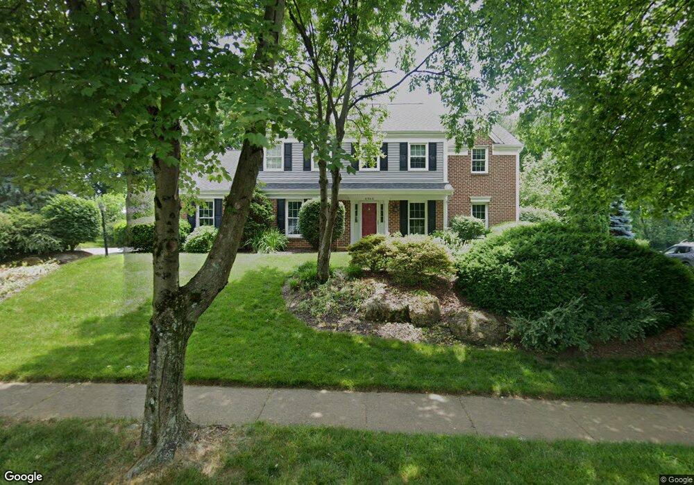
4964 Bridlepath Dr Macungie, PA 18062
Estimated Value: $545,363 - $699,000
4
Beds
3
Baths
2,563
Sq Ft
$236/Sq Ft
Est. Value
About This Home
This home is located at 4964 Bridlepath Dr, Macungie, PA 18062 and is currently estimated at $603,841, approximately $235 per square foot. 4964 Bridlepath Dr is a home located in Lehigh County with nearby schools including Wescosville Elementary School, Lower Macungie Middle School, and Emmaus High School.
Ownership History
Date
Name
Owned For
Owner Type
Purchase Details
Closed on
Aug 24, 1999
Sold by
Murphy Robert X and Murphy Mary Margaret
Bought by
Ettinger Scott L and Ettinger Catherine M
Current Estimated Value
Purchase Details
Closed on
Mar 11, 1993
Sold by
Murphy Robert X and Murphy Rosemary E
Bought by
Murphy Robert X
Purchase Details
Closed on
Oct 25, 1989
Sold by
Smith Andrew T and Smith Shelley M
Bought by
Murphy Robert X and Murphy Rosemary E
Purchase Details
Closed on
Aug 13, 1982
Sold by
Wanner Daniel B and Wanner Virginia B
Bought by
Smith Andrew T and Smith Shelley M
Purchase Details
Closed on
Feb 18, 1982
Bought by
Wanner Daniel B and Wanner Virginia B
Create a Home Valuation Report for This Property
The Home Valuation Report is an in-depth analysis detailing your home's value as well as a comparison with similar homes in the area
Home Values in the Area
Average Home Value in this Area
Purchase History
| Date | Buyer | Sale Price | Title Company |
|---|---|---|---|
| Ettinger Scott L | $220,000 | -- | |
| Murphy Robert X | -- | -- | |
| Murphy Robert X | $250,000 | -- | |
| Smith Andrew T | $138,500 | -- | |
| Wanner Daniel B | $29,500 | -- |
Source: Public Records
Tax History Compared to Growth
Tax History
| Year | Tax Paid | Tax Assessment Tax Assessment Total Assessment is a certain percentage of the fair market value that is determined by local assessors to be the total taxable value of land and additions on the property. | Land | Improvement |
|---|---|---|---|---|
| 2025 | $6,885 | $269,700 | $42,300 | $227,400 |
| 2024 | $6,662 | $269,700 | $42,300 | $227,400 |
| 2023 | $6,529 | $269,700 | $42,300 | $227,400 |
| 2022 | $6,374 | $269,700 | $227,400 | $42,300 |
| 2021 | $6,239 | $269,700 | $42,300 | $227,400 |
| 2020 | $6,179 | $269,700 | $42,300 | $227,400 |
| 2019 | $6,074 | $269,700 | $42,300 | $227,400 |
| 2018 | $5,994 | $269,700 | $42,300 | $227,400 |
| 2017 | $5,889 | $269,700 | $42,300 | $227,400 |
| 2016 | -- | $269,700 | $42,300 | $227,400 |
| 2015 | -- | $269,700 | $42,300 | $227,400 |
| 2014 | -- | $269,700 | $42,300 | $227,400 |
Source: Public Records
Map
Nearby Homes
- 5175 Meadowview Dr
- 4762 Steeplechase Dr Unit 13C
- 2173 Brookside Rd
- 1675 Hamlet Dr
- 5133 Meadow Ln
- 5280 Townsquare Dr
- Henley Plan at Mountainview Estates
- Penny Plan at Mountainview Estates
- 2041 Gregory Dr
- 2153 Isabel Ln
- 2096 Gregory Dr
- 2117 Isabel Ln
- 2518 Stanford Cir
- 2560 Gracie Lone
- 2570 Millbrook Dr
- 1991 Autumn Ridge Rd
- 1385 Brookside Rd
- 2056 Autumn Ridge Rd
- 2691 Terrwood Dr W Unit 176
- 1270 Minesite Rd
- 4950 Bridlepath Dr
- 4978 Bridlepath Dr
- 2045 Dougherty Cir
- 1985 Fallow Ct
- 4957 Bridlepath Dr
- 4971 Bridlepath Dr
- 4938 Bridlepath Dr
- 4943 Bridlepath Dr
- 2050 Dougherty Cir
- 4981 Bridlepath Dr
- 4926 Bridlepath Dr
- 4929 Bridlepath Dr
- 2025 Dougherty Cir
- 5010 Bridlepath Dr
- 1980 Emerald Isle Cir
- 1975 Fallow Ct
- 5015 Bridlepath Dr
- 1980 Fallow Ct
- 2060 Dougherty Cir
- 4915 Bridlepath Dr