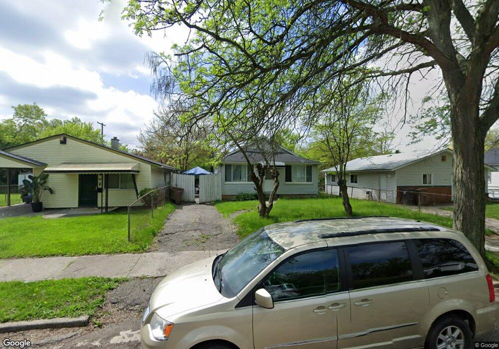
497 Ditmar Ave Pontiac, MI 48341
Estimated Value: $71,000 - $117,000
2
Beds
1
Bath
988
Sq Ft
$100/Sq Ft
Est. Value
About This Home
This home is located at 497 Ditmar Ave, Pontiac, MI 48341 and is currently estimated at $98,601, approximately $99 per square foot. 497 Ditmar Ave is a home located in Oakland County with nearby schools including Walt Whitman Elementary School, Pontiac Middle School, and Pontiac High School.
Ownership History
Date
Name
Owned For
Owner Type
Purchase Details
Closed on
Jan 30, 2025
Sold by
Muro Jose Antonio Garcia
Bought by
Arellano Alan Gaeta
Current Estimated Value
Purchase Details
Closed on
May 7, 2020
Sold by
Martinez Alma Lizethe Prieto
Bought by
Muro Jose Antonio Garcia
Purchase Details
Closed on
Dec 17, 2010
Sold by
Alobaid Wesam Salah Ahmed
Bought by
Prieto Lendy Gizel Muro and Prieto Alma Lizethe Prieto
Purchase Details
Closed on
May 8, 2007
Sold by
Page Lurline
Bought by
Hsbc Bank Usa Na and Ownit Mortgage Loan Trust Mortgage Loan
Purchase Details
Closed on
Aug 16, 1996
Sold by
Page Hortense
Bought by
Page Lurline
Create a Home Valuation Report for This Property
The Home Valuation Report is an in-depth analysis detailing your home's value as well as a comparison with similar homes in the area
Home Values in the Area
Average Home Value in this Area
Purchase History
| Date | Buyer | Sale Price | Title Company |
|---|---|---|---|
| Arellano Alan Gaeta | -- | None Listed On Document | |
| Arellano Alan Gaeta | -- | None Listed On Document | |
| Muro Jose Antonio Garcia | -- | None Available | |
| Prieto Lendy Gizel Muro | $9,000 | None Available | |
| Hsbc Bank Usa Na | $82,286 | None Available | |
| Page Lurline | $1,500 | -- |
Source: Public Records
Tax History Compared to Growth
Tax History
| Year | Tax Paid | Tax Assessment Tax Assessment Total Assessment is a certain percentage of the fair market value that is determined by local assessors to be the total taxable value of land and additions on the property. | Land | Improvement |
|---|---|---|---|---|
| 2024 | $666 | $23,810 | $0 | $0 |
| 2023 | $635 | $21,310 | $0 | $0 |
| 2022 | $679 | $18,120 | $0 | $0 |
| 2021 | $710 | $15,920 | $0 | $0 |
| 2020 | $506 | $14,130 | $0 | $0 |
| 2019 | $554 | $12,090 | $0 | $0 |
| 2018 | $524 | $10,270 | $0 | $0 |
| 2017 | $506 | $9,980 | $0 | $0 |
| 2016 | $534 | $9,480 | $0 | $0 |
| 2015 | -- | $9,560 | $0 | $0 |
| 2014 | -- | $8,440 | $0 | $0 |
| 2011 | -- | $15,350 | $0 | $0 |
Source: Public Records
Map
Nearby Homes
- 483 Pearsall Ave
- 470 Fildew Ave
- 559 Arthur Ave
- 533 California Ave
- 587 California Ave
- 0000 Franklin Rd
- 485 Colorado Ave
- 466 Colorado Ave
- 567 Highland Ave
- 472 Wyoming Ave
- 605 Nebraska Ave
- 371 Nebraska Ave
- 534 Nevada Ave
- 499 Bloomfield Ave
- 598 Montana Ave
- 273 Dellwood Ave
- 305 South Blvd W
- 151 South Blvd W
- 200 Crystal Lake Dr
- 200 Astorwood St