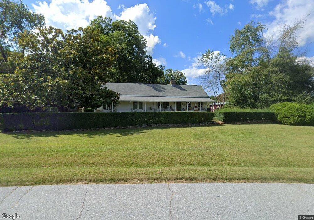
497 Old Blairsville Rd Cleveland, GA 30528
Estimated Value: $302,000 - $384,000
3
Beds
2
Baths
2,092
Sq Ft
$158/Sq Ft
Est. Value
About This Home
This home is located at 497 Old Blairsville Rd, Cleveland, GA 30528 and is currently estimated at $331,221, approximately $158 per square foot. 497 Old Blairsville Rd is a home located in White County with nearby schools including White County 9th Grade Academy, Tesnatee Gap Elementary (Old White County Intermediate), and Jack P. Nix Elementary School.
Ownership History
Date
Name
Owned For
Owner Type
Purchase Details
Closed on
Apr 19, 2019
Sold by
Rewis Martha Jacqueline
Bought by
Dever Wanda R and Dever Edward P
Current Estimated Value
Purchase Details
Closed on
Apr 20, 2010
Sold by
Rewis Martha Jacqueline
Bought by
Rewis Martha Jacqueline
Create a Home Valuation Report for This Property
The Home Valuation Report is an in-depth analysis detailing your home's value as well as a comparison with similar homes in the area
Home Values in the Area
Average Home Value in this Area
Purchase History
| Date | Buyer | Sale Price | Title Company |
|---|---|---|---|
| Dever Wanda R | -- | -- | |
| Rewis Martha Jacqueline | -- | -- |
Source: Public Records
Tax History Compared to Growth
Tax History
| Year | Tax Paid | Tax Assessment Tax Assessment Total Assessment is a certain percentage of the fair market value that is determined by local assessors to be the total taxable value of land and additions on the property. | Land | Improvement |
|---|---|---|---|---|
| 2025 | -- | $64,344 | $14,544 | $49,800 |
| 2024 | -- | $64,344 | $14,544 | $49,800 |
| 2023 | $0 | $58,204 | $10,908 | $47,296 |
| 2022 | $0 | $44,356 | $10,304 | $34,052 |
| 2021 | $0 | $37,028 | $8,636 | $28,392 |
| 2020 | $437 | $35,700 | $8,128 | $27,572 |
| 2019 | $437 | $35,700 | $8,128 | $27,572 |
| 2018 | $437 | $35,700 | $8,128 | $27,572 |
| 2017 | $376 | $35,064 | $8,128 | $26,936 |
| 2016 | $376 | $35,064 | $8,128 | $26,936 |
| 2015 | $359 | $87,660 | $8,128 | $26,936 |
| 2014 | $580 | $71,640 | $0 | $0 |
Source: Public Records
Map
Nearby Homes
- 213 Jackson Heights
- 201 Jackson Heights Unit 7
- 189 Jackson Heights
- 189 Jackson Heights Unit 5
- 183 Jackson Heights Unit 4
- 183 Jackson Heights
- 177 Jackson Heights
- 171 Jackson Heights Unit 2
- 171 Jackson Heights
- 165 Jackson Heights Unit 1
- 231 Doug Allison Heights
- 0 Helen Hwy Unit 10640779
- 53 Jackson Cir
- 62 North Ave
- LOT 5 Stacey Dr
- 0 W Kytle St Unit 10623685
- 93 Colonial Dr
- 302 Cantrell Rd
- 0 Appalachian Pkwy Unit 22327486
- 1 E Jarrard St
- 439 Old Blairsville Rd
- 499 Old Blairsville Rd
- 67 Kinnimer St
- 0 Skywater Point Unit 194 8343730
- 0 Old 75 Westmoreland Unit 8308432
- 0 Old 75 Westmoreland Unit 8284921
- 0 Claude Sims Shepherd Unit 3052567
- 0 Highway 75 Helen Hwy Unit 3093328
- 0 Asbury Landing Unit 2912486
- 0 Twin Ridge Acres Unit 3184858
- 0 Asbury Landing Unit 7026329
- 0 Off Duncan Bridge Unit 3 7150745
- 0 Asbury Landing Unit 40 7158442
- 0 Asbury Landing Unit 39 7158424
- 0 Asbury Landing Unit 36 7158397
- 0 Old Hwy 75 S Unit 7252971
- 0 Asbury Landing Unit 40 7343652
- 0 Asbury Landing Unit 40 7432555
- 0 Asbury Landing Unit 39 7433790
- 49 Mountainside Dr Unit L