A
Seller's Agent in 2024
Aniela Wasmanski
LIV Sotheby's I.R.
(970) 409-8476
20 in this area
146 Total Sales


Estimated Value: $371,000 - $446,359
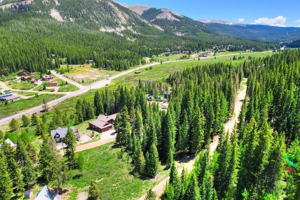
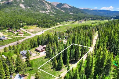
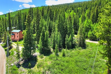
Exceptional land opportunity that blends a breathtaking natural mountain landscape with endless possibilities. This .53-acre parcel offers an incredibly limited chance to build your dream mountain home or invest in the future right in the heart of Blue River. Architectural plans for a 4 BD / 3.5 BA mountain modern residence with 2,300SF of finished living space are included with the purchase. Town sewer, electric and natural gas are available to connect at the road. As a Town of Blue River resident you have access to recreational use of the Goose Pasture Tarn and the ability to short-term rent any future home that is constructed. Experience all that Breckenridge has to offer with a quick 10-minute drive to Main Street!
Last Agent to Sell the Property
LIV Sotheby's I.R. Brokerage Phone: 970-409-8476 License #FA100068214 Listed on: 02/20/2024

We collect this data history from publicly available records. To have your information removed, we recommend requesting removal directly through your county’s website.
We collect this data history from publicly available records. To have your information removed, we recommend requesting removal directly through your county’s website.
| Date | Buyer | Sale Price | Title Company |
|---|---|---|---|
| $405,000 | Land Title | ||
| $350,000 | None Listed On Document | ||
| $162,500 | Stewart Title |
We collect this data history from publicly available records. To have your information removed, we recommend requesting removal directly through your county’s website.
| Date | Status | Borrower | Loan Amount |
|---|---|---|---|
| Previous Owner | $130,000 |
We collect this data history from publicly available records. To have your information removed, we recommend requesting removal directly through your county’s website.
| Date | Event | Price | List to Sale | Price per Sq Ft |
|---|---|---|---|---|
| 06/25/2024 06/25/24 | Sold | $405,000 | -18.8% | -- |
| 05/23/2024 05/23/24 | Pending | -- | -- | -- |
| 04/23/2024 04/23/24 | Price Changed | $499,000 | -3.1% | -- |
| 02/20/2024 02/20/24 | For Sale | $515,000 | -- | -- |
We collect this data history from publicly available records. To have your information removed, we recommend requesting removal directly through your county’s website.
| Year | Tax Paid | Tax Assessment Tax Assessment Total Assessment is a certain percentage of the fair market value that is determined by local assessors to be the total taxable value of land and additions on the property. | Land | Improvement |
|---|---|---|---|---|
| 2024 | $5,283 | $94,540 | $94,540 | -- |
| 2023 | $5,283 | $90,954 | $0 | $0 |
| 2022 | $2,595 | $40,020 | $0 | $0 |
| 2021 | $2,574 | $40,020 | $0 | $0 |
| 2020 | $2,210 | $34,127 | $0 | $0 |
| 2019 | $2,185 | $34,127 | $0 | $0 |
| 2018 | $2,487 | $37,862 | $0 | $0 |
| 2017 | $2,314 | $37,862 | $0 | $0 |
| 2016 | $1,542 | $24,914 | $0 | $0 |
| 2015 | $1,502 | $24,914 | $0 | $0 |
| 2014 | $1,665 | $27,319 | $0 | $0 |
| 2013 | -- | $27,319 | $0 | $0 |
A
Seller's Agent in 2024
Aniela Wasmanski
LIV Sotheby's I.R.
(970) 409-8476
20 in this area
146 Total Sales
Buyer's Agent in 2024
Luke Peffrath
Paffrath & Thomas R.E.S.C
(970) 485-2045
10 in this area
65 Total Sales
Source: Summit MLS
MLS Number: S1046668
APN: 100481
Disclaimer: Certain information contained herein is derived from information provided by parties other than Homes.com. All information provided is deemed reliable, but is not guaranteed to be accurate and should be independently verified.
![]() Copyright © 2026 SAR MLS. The information displayed herein was derived from sources believed to be accurate, but has not been verified by SAR MLS. Buyers are cautioned to verify all information to their own satisfaction. This information is exclusively for viewers’ personal, non-commercial use. Any republication or reproduction of the information herein without the express permission of the SAR MLS is strictly prohibited.
Copyright © 2026 SAR MLS. The information displayed herein was derived from sources believed to be accurate, but has not been verified by SAR MLS. Buyers are cautioned to verify all information to their own satisfaction. This information is exclusively for viewers’ personal, non-commercial use. Any republication or reproduction of the information herein without the express permission of the SAR MLS is strictly prohibited.
Ask me questions while you tour the home.